An estuary is a partially enclosed coastal body of brackish water with one or more rivers or streams flowing into it, and with a free connection to the open sea. Estuaries form a transition zone between river environments and maritime environments and are an example of an ecotone. Estuaries are subject both to marine influences such as tides, waves, and the influx of saline water, and to fluvial influences such as flows of freshwater and sediment. The mixing of seawater and freshwater provides high levels of nutrients both in the water column and in sediment, making estuaries among the most productive natural habitats in the world.

The National Estuarine Research Reserve System is a network of 30 protected areas established by partnerships between the National Oceanic and Atmospheric Administration (NOAA) and coastal states. The reserves represent different biogeographic regions of the United States. The National Estuarine Research Reserve System protects more than 1.3 million acres of coastal and estuarine habitats for long-term research, water-quality monitoring, education, and coastal stewardship.

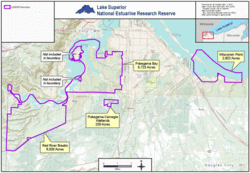
The Saint Louis River is a river in the U.S. states of Minnesota and Wisconsin that flows into Lake Superior. The largest U.S. river to flow into the lake, it is 192 miles (309 km) in length and starts 13 miles (21 km) east of Hoyt Lakes, Minnesota. The river's watershed covers 3,634 square miles (9,410 km2). Near the Twin Ports of Duluth, Minnesota and Superior, Wisconsin, the river becomes a freshwater estuary.

The Apalachicola River is a river, approximately 160 miles (260 km) long, in the state of Florida. The river's large watershed, known as the Apalachicola, Chattahoochee and Flint (ACF) River Basin, drains an area of approximately 19,500 square miles (50,500 km2) into the Gulf of Mexico. The distance to its farthest head waters in northeast Georgia is approximately 500 miles (800 km). Its name comes from Apalachicola Province, an association of Native American towns located on what is now the Chattahoochee River. The Spanish included what is now called the Chattahoochee River as part of one river, calling all of it from its origins in the southern Appalachian foothills down to the Gulf of Mexico the Apalachicola.

Coos Bay is an estuary where the Coos River enters the Pacific Ocean, the estuary is approximately 12 miles long and up to two miles wide. It is the largest estuary completely within Oregon state lines. The Coos Bay watershed covers an area of about 600 square miles and is located in northern Coos County, Oregon, in the United States. The Coos River, which begins in the Oregon Coast Range, enters the bay from the east. From Coos River, the bay forms a sharp loop northward before arching back to the south and out to the Pacific Ocean. Haynes Inlet enters the top of this loop. South Slough branches off from the bay directly before its entrance into the Pacific Ocean. The bay was formed when sea levels rose over 20,000 years ago at the end of the Last Glacial Maximum, flooding the mouth of the Coos River. Coos Bay is Oregon's most important coastal industrial center and international shipping port, with close ties to San Francisco, the Columbia River, Puget Sound and other major ports of the Pacific rim.
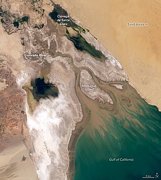
The Colorado River Delta is the region where the Colorado River flows into the Gulf of California in eastern Mexicali Municipality in the north of the state of Baja California in northwesternmost Mexico. The delta is part of a larger geologic region called the Salton Trough. Historically, the interaction of the river's flow and the ocean's tide created a dynamic environment, supporting freshwater, brackish, and saltwater species. Within the delta region, the river split into multiple braided channels and formed a complex estuary and terrestrial ecosystems. The use of water upstream and the accompanying reduction of freshwater flow has resulted in the loss of most of the wetlands of the area, as well as drastic changes to the aquatic ecosystems. However, a scheme is currently in place which aims to rejuvenate the wetlands by releasing a pulse of water down the river delta.

Humboldt Lagoons State Park is a California State Park on the Redwood Coast, in Humboldt County, California. It is located along U.S. Route 101 between Trinidad and Orick. The park protects three lagoons with estuaries and wetlands.

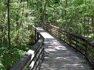
The Jug Bay Wetlands Sanctuary is located along the tidal Patuxent River in southern Maryland, United States. It was established in 1985 and is operated by the Anne Arundel County Department of Recreation and Parks. It includes more than 1,700 acres (6.9 km2) of tidal freshwater wetlands, forests, meadows and fields. The wetlands, with large stands of aquatic plants including wild rice, are home to many birds, fish, reptiles, amphibians, and mammals. Miles of trails and boardwalks traverse a variety of habitats and provide glimpses into the rich history of the region. Notably, archaeologists have uncovered evidence of a large Native American settlement at Jug Bay which spanned 2 miles along the Patuxent, with the oldest arrowhead-like artifact dated between 8,000 to 8,900 years old.
The Chesapeake Bay National Estuarine Research Reserve is an estuary reserve in Maryland.
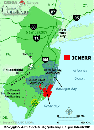
The Jacques Cousteau National Estuarine Research Reserve, located in southeastern New Jersey, encompasses over 110,000 acres (450 km2) of terrestrial, wetland and aquatic habitats within the Mullica River-Great Bay Ecosystem.

Great Bay is located in southern New Jersey's Atlantic Coastal Plain in Ocean and Atlantic Counties, about ten miles (16 km) north of Atlantic City and 87 mi (140 km) south of New York City. The Mullica River flows into the bay, and together they form the Mullica River - Great Bay estuary habitat. The bay is connected to the Atlantic Ocean via the Little Egg Inlet. Great Bay is considered one of the least-disturbed marine wetlands habitats in the northeastern United States.

Elkhorn Slough is a 7-mile-long (11 km) tidal slough and estuary on Monterey Bay in Monterey County, California. It is California's second largest estuary and the United States' first estuarine sanctuary. The community of Moss Landing and the Moss Landing Power Plant are located at the mouth of the slough on the bay.
The Delaware National Estuarine Research Reserve consists of two unique components, one on Blackbird Creek and the other on the St. Jones River. Freshwater wetlands, ponds and forest lands dominate the Blackbird Creek component. The St. Jones component is dominated by salt marsh and open water habitats of the Delaware Bay.
The Great Bay National Estuarine Research Reserve encompasses a diversity of land and water areas around Great Bay, an estuary in southeastern New Hampshire. Protected lands cover 10,235 acres (4,142 ha), including approximately 7,300 acres (3,000 ha) of open water and wetlands that include salt marshes, rocky shores, bluffs, woodlands, open fields, and riverine systems and tidal waters.
The Weeks Bay National Estuarine Research Reserve is a field laboratory and research facility along Weeks Bay estuary, about 6,000 acres (2,400 ha) in size. It receives freshwater from the Magnolia and Fish Rivers, and drains a 198 square miles (510 km2) watershed into the portion of Mobile Bay via a narrow opening. This sub-estuary of Mobile Bay averages just 4.8 ft deep and is fringed with marsh and swamp. The reserve lands also include upland and bottomland hardwood forests, freshwater marsh, submerged aquatic vegetation and unique bog habitats. Weeks Bay is a critical nursery for shrimp, bay anchovy, blue crab and multitudes of other fish, crustaceans and shellfish that support robust commercial fisheries providing $450 million/year for Alabama.

The Tijuana River Estuary is an intertidal coastal wetland at the mouth of the Tijuana River in San Diego County, California, in the United States bordering Tijuana, Baja California, Mexico. It is the location of the Tijuana River National Estuarine Research Reserve, Tijuana Slough National Wildlife Refuge, Border Field State Park, and Tijuana River Valley Regional Park. The estuary is a shallow water habitat. Often termed an intermittent estuary since its volume is subject to the discharge controlled by the seasons of the year, the volume of the estuary fluctuates and at times there is dry land, or flooded areas. It was designated a National Natural Landmark in 1973.

The Hunter Estuary Wetlands comprise a group of associated wetlands at and near the mouth of the Hunter River in the city of Newcastle, New South Wales, Australia. The wetlands are part of Hunter Wetlands National Park. 30 km2 of the wetlands have been recognised as being of international importance by designation under the Ramsar Convention. It was listed on 21 February 1984 as Ramsar site 287. A larger area of the wetlands has been identified by BirdLife International as an Important Bird Area (IBA). The wetlands are recognised as the most important area in New South Wales for waders, or shorebirds.

Moulting Lagoon Important Bird Area is a composite wetland site in eastern Tasmania, Australia. It comprises two adjacent and hydrologically continuous wetlands – Moulting Lagoon and the Apsley Marshes – at the head of Great Oyster Bay, near the base of the Freycinet Peninsula, between the towns of Swansea and Bicheno. Both components of the site are listed separately under the Ramsar Convention as wetlands of international significance. Moulting Lagoon is so named because it is a traditional moulting place for black swans. It is an important site for waterbirds.

The U.S. state of Texas has a series of estuaries along its coast on the Gulf of Mexico, most of them bounded by the Texas barrier islands. Estuaries are coastal bodies of water in which freshwater from rivers mixes with saltwater from the sea. Twenty-one drainage basins terminate along the Texas coastline, forming a chain of seven major and five minor estuaries: listed from southwest to northeast, these are the Rio Grande Estuary, Laguna Madre, the Nueces Estuary, the Mission–Aransas Estuary, the Guadalupe Estuary, the Colorado–Lavaca Estuary, East Matagorda Bay, the San Bernard River and Cedar Lakes Estuary, the Brazos River Estuary, Christmas Bay, the Trinity–San Jacinto Estuary, and the Sabine–Neches Estuary. Each estuary is named for its one or two chief contributing rivers, excepting Laguna Madre, East Matagorda Bay, and Christmas Bay, which have no major river sources. The estuaries are also sometimes referred to by the names of their respective primary or central water bodies, though each also includes smaller secondary bays, inlets, or other marginal water bodies.