The National Estuarine Research Reserve System is a network of 30 protected areas established by partnerships between the National Oceanic and Atmospheric Administration (NOAA) and coastal states. The reserves represent different biogeographic regions of the United States. The National Estuarine Research Reserve System protects more than 1.3 million acres of coastal and estuarine habitats for long-term research, water-quality monitoring, education, and coastal stewardship.

The Elkhorn Slough National Estuarine Research Reserve is a nature reserve that is located at 1700 Elkhorn Road in Watsonville, California. The reserve encompasses the central shore of Monterey Bay and is approximately 100 miles (160 km) south of San Francisco, California. The Elkhorn Slough is established as a part of the National Oceanic and Atmospheric Administration and is being managed as the Elkhorn Slough Ecological Reserve through the California Department of Fish and Wildlife.
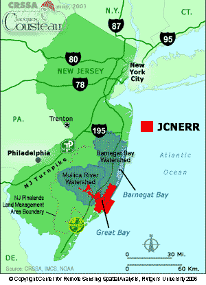
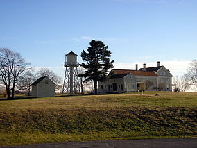
The Jacques Cousteau National Estuarine Research Reserve, located in southeastern New Jersey, encompasses over 110,000 acres (450 km2) of terrestrial, wetland and aquatic habitats within the Mullica River-Great Bay Ecosystem.
Rookery Bay National Estuarine Research Reserve protects 110,000 acres of coastal lands and waters at the northern end of the Ten Thousand Islands on the gulf coast of Florida, Rookery Bay National Estuarine Research Reserve represents one of the few remaining undisturbed mangrove estuaries in North America.

In 1999, the Guana Tolomato Matanzas National Estuarine Research Reserve was designated in St. Johns and Flagler counties, Florida as a part of the National Oceanic and Atmospheric Administration (NOAA) National Estuarine Research Reserve (NERR) system. The GTM Research Reserve represents the east Florida sub-region of the Carolinian bioregion. It is one of 30 NERRs in 23 states and one territory. GTM is one of three NERRs in Florida and is administered on behalf of the state by the Florida Department of Environmental Protection's Florida Coastal Office as part of a network that includes forty-one aquatic preserves, three NERRs, a National Marine Sanctuary, the Coral Reef Conservation Program and the Florida Oceans and Coastal Council. Additional interests are held in the research and management of the GTM and connected preserved or conserved lands including:

The Rachel Carson National Wildlife Refuge is a 9,125-acre (37 km2) National Wildlife Refuge made up of several parcels of land along 50 miles (80 km) of Maine's southern coast. Created in 1966, it is named for environmentalist and author Rachel Carson, whose book Silent Spring raised public awareness of the effects of DDT on migratory songbirds, and of other environmental issues.

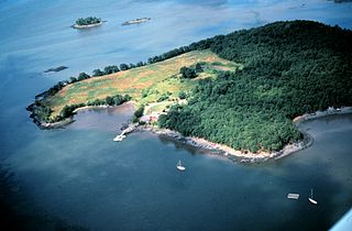
Elkhorn Slough is a 7-mile-long (11 km) tidal slough and estuary on Monterey Bay in Monterey County, California. It is California's second largest estuary and the United States' first estuarine sanctuary. The community of Moss Landing and the Moss Landing Power Plant are located at the mouth of the slough on the bay.
Moro Cojo Estuary State Marine Reserve (SMR) is a marine protected area established to protect the wildlife and habitats in Moro Cojo Slough. Moro Cojo Slough is located inland from Monterey Bay on the central coast of California, directly south of the more widely known Elkhorn Slough. The area covers 0.46 square miles (1.2 km2). The SMR protects all marine life within its boundaries. Fishing and take of all living marine resources is prohibited.

The Grand Bay National Estuarine Research Reserve is one of the most biologically productive estuarine ecosystems in the Gulf of Mexico region, supporting several rare or endangered plant and animal species, numerous important marine fishery resources, diverse habitat types and archaeological sites, in the U.S. State of Mississippi.

The Ashepoo Combahee Edisto Basin National Estuarine Research Reserve is a 140,000-acre (570 km2) reserve area located in the ACE Basin, one of the largest undeveloped estuaries on the Atlantic coast of the United States. It is named for the Ashepoo, Combahee and Edisto Rivers, which flow past cypress swamps, historic plantation houses, old rice fields and tidal marshes to meet at South Carolina's biologically rich St. Helena Sound.
The Delaware National Estuarine Research Reserve consists of two unique components, one on Blackbird Creek and the other on the St. Jones River. Freshwater wetlands, ponds and forest lands dominate the Blackbird Creek component. The St. Jones component is dominated by salt marsh and open water habitats of the Delaware Bay.
The Great Bay National Estuarine Research Reserve encompasses a diversity of land and water areas around Great Bay, an estuary in southeastern New Hampshire. Protected lands cover 10,235 acres (4,142 ha), including approximately 7,300 acres (3,000 ha) of open water and wetlands that include salt marshes, rocky shores, bluffs, woodlands, open fields, and riverine systems and tidal waters.

The Mashpee National Wildlife Refuge is a National Wildlife Refuge in the state of Massachusetts. Established in 1995, it is administered by the Eastern Massachusetts National Wildlife Complex. The refuge includes a surface area of 537.12 acres (2.1736 km2) managed by U.S. Fish and Wildlife Service. The refuge encompasses a total of 5,971 acres (24.16 km2), as established by the United States Congress.

Grand Bay National Wildlife Refuge was established in 1992 under the Emergency Wetlands Resources Act of 1986 to protect one of the largest expanses of undisturbed pine savanna habitats in the Gulf Coastal Plain region. The refuge is located near Grand Bay, Alabama in Mobile County, Alabama and Jackson County, Mississippi, and when complete will encompass over 32,000 acres (130 km2). The refuge is part of the National Wildlife Refuge system. The Refuge Complex Manager also administers the Mississippi Sandhill Crane National Wildlife Refuge and Bon Secour National Wildlife Refuge. Access to refuge lands is limited, but is available mostly on the Mississippi side and by boat.

Tijuana Slough National Wildlife Refuge is located in the most southwestern corner of the contiguous United States. As a National Wildlife Refuge, it is administered by the U.S. Fish and Wildlife Service. It was established in 1980.
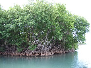
Mangrove ecosystems represent natural capital capable of producing a wide range of goods and services for coastal environments and communities and society as a whole. Some of these outputs, such as timber, are freely exchanged in formal markets. Value is determined in these markets through exchange and quantified in terms of price. Mangroves are important for aquatic life and home for many species of fish.
Moss Landing Wildlife Area is a California State wildlife preserve on the shore of Elkhorn Slough.
The San Diego National Wildlife Refuge Complex is a series of wildlife refuges established by the United States National Wildlife Service beginning in 1972. The complex incorporates five refuges in San Diego County and Orange County in California.

The North Norfolk Coast Site of Special Scientific Interest (SSSI) is an area of European importance for wildlife in Norfolk, England. It comprises 7,700 ha (19,027 acres) of the county's north coast from just west of Holme-next-the-Sea to Kelling, and is additionally protected through Natura 2000, Special Protection Area (SPA) listings; it is also part of the Norfolk Coast Area of Outstanding Natural Beauty (AONB). The North Norfolk Coast is also designated as a wetland of international importance on the Ramsar list and most of it is a Biosphere Reserve.

Hurst Castle and Lymington River Estuary is a 1,077.3-hectare (2,662-acre) biological and geological Site of Special Scientific Interest near Lymington in Hampshire. It is a Nature Conservation Review site and two areas are Geological Conservation Review sites. Three areas are local nature reserves, Boldre Foreshore, Sturt Pond and Lymington and Keyhaven Marshes; the latter site is managed by the Hampshire and Isle of Wight Wildlife Trust. Part of it is North Solent National Nature Reserve. It is part of Solent and Southampton Water Ramsar site and Special Protection Area. Parts of it are in Solent Maritime and Solent and Isle of Wight Lagoons Special Areas of Conservation.