Lakeland North, Washington

Last updated
Lakeland North, Washington
King County Washington Incorporated and Unincorporated areas Lakeland North Highlighted.svg
Location of Lakeland North, Washington
Coordinates: 47°20′13″N122°16′54″W / 47.33694°N 122.28167°W / 47.33694; -122.28167
Country United States
State Washington
County King
Area
  Total3.36 sq mi (8.69 km2)
  Land3.25 sq mi (8.41 km2)
  Water0.11 sq mi (0.28 km2)
Elevation
420 ft (130 m)
Population
 (2020)
  Total13,663
  Density4,100/sq mi (1,600/km2)
Time zone UTC-8 (Pacific (PST))
  Summer (DST) UTC-7 (PDT)
FIPS code 53-37420 [1]
GNIS feature ID2408558 [2]

Lakeland North is a census-designated place (CDP) in King County, Washington, United States. The population was 13,663 at the 2020 census. [3] Part of the community was annexed into neighboring Auburn in 2008.

Contents

Geography

Lakeland North is located in southwestern King County at 47°19′58″N122°16′37″W / 47.33278°N 122.27694°W / 47.33278; -122.27694 (47.332822, -122.276997). [4] It is bordered to the east by Auburn, to the south and west by Federal Way, and to the north by Kent. Interstate 5 runs along the west edge of the community, with access from Exit 143 (South 320th Street) at the southwest corner of the CDP and from Exit 147 (South 272nd Street) at the northwest corner. I-5 leads north 21 miles (34 km) to downtown Seattle and south 11 miles (18 km) to Tacoma.

According to the United States Census Bureau, the Lakeland North CDP has a total area of 3.4 square miles (8.7 km2), of which 3.2 square miles (8.4 km2) are land and 0.1 square miles (0.3 km2), or 3.24%, are water. [5] Lake Dolloff is in the southern part of the community, and Star Lake is in the north.

Demographics

Historical population
CensusPop.Note
1980 11,648
1990 14,40223.6%
2000 15,0854.7%
2010 12,942−14.2%
2020 13,6635.6%
source: [6]

At the 2000 census there were 15,085 people, 4,978 households, and 4,101 families in the CDP. The population density was 2,841.4 people per square mile (1,096.9/km2). There were 5,067 housing units at an average density of 954.4/sq mi (368.4/km2). The racial makup was 82.45% White, 3.41% African American, 1.07% Native American, 6.95% Asian, 0.50% Pacific Islander, 1.62% from other races, and 4.00% from two or more races. Hispanic or Latino of any race were 3.56%. [1]

Of the 4,978 households 43.3% had children under the age of 18 living with them, 68.8% were married couples living together, 8.8% had a female householder with no husband present, and 17.6% were non-families. 12.0% of households were one person and 2.9% were one person aged 65 or older. The average household size was 3.03 and the average family size was 3.29.

The age distribution was 30.0% under the age of 18, 7.0% from 18 to 24, 31.6% from 25 to 44, 24.5% from 45 to 64, and 6.8% 65 or older. The median age was 36 years. For every 100 females there were 98.5 males. For every 100 females age 18 and over, there were 97.3 males.

The median household income was $62,292 and the median family income was $64,158. Males had a median income of $45,199 versus $31,753 for females. The per capita income was $23,776. About 3.4% of families and 5.1% of the population were below the poverty line, including 5.7% of those under age 18 and 4.2% of those age 65 or over.

Related Research Articles

<span class="mw-page-title-main">Istachatta, Florida</span> Census-designated place in Florida, United States

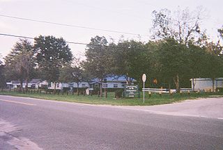
Istachatta is an unincorporated community and census-designated place (CDP) in Hernando County, Florida, United States. The population was 116 at the 2010 census, up from 65 at the 2000 census. The name "Istachatta" is derived from a Seminole word meaning "man snake".

<span class="mw-page-title-main">Palm Springs North, Florida</span> Census-designated place in Florida

Palm Springs North is an unincorporated community and census-designated place (CDP) in Miami-Dade County, Florida, United States. It is part of the Miami metropolitan area of South Florida. The population was 5,030 at the 2020 census.

<span class="mw-page-title-main">Lakeland Highlands, Florida</span> Census-designated place in Florida, United States

Lakeland Highlands is an unincorporated community and census-designated place (CDP) in Polk County, Florida, United States. The population was 11,056 at the 2010 census. It is part of the Lakeland–Winter Haven Metropolitan Statistical Area. It is an affluent residential community located south of the Lakeland city limits, and north of the Mulberry city limits. Lakeland Highlands neighbors Medulla, and together the two communities make up much of what is known as South Lakeland (unincorporated).

<span class="mw-page-title-main">White City, St. Lucie County, Florida</span> CDP in Florida, United States

White City is a census-designated place (CDP) in St. Lucie County, Florida, United States. The population was 3,719 at the 2010 census. It is part of the Port St. Lucie Metropolitan Statistical Area.

<span class="mw-page-title-main">Dayton, Montana</span> Census-designated place in Montana, United States

Dayton is an unincorporated community and census-designated place (CDP) in Lake County, Montana, United States. The population was 84 at the 2010 census.

<span class="mw-page-title-main">University Park, New Mexico</span> Census-designated place in New Mexico, United States

University Park is a census-designated place (CDP) in Doña Ana County, New Mexico, United States. The population was 4,192 at the 2010 census. It is part of the Las Cruces Metropolitan Statistical Area.

<span class="mw-page-title-main">Cottage Lake, Washington</span> Census-designated place in Washington, United States

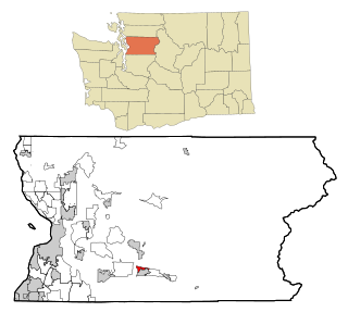
Cottage Lake is a census-designated place (CDP) in King County, Washington, United States. The population was 22,494 at the 2010 census. The lake itself falls within the 98072 ZIP code, while the developments east of the lake fall under the 98077 ZIP code.

<span class="mw-page-title-main">East Hill-Meridian, Washington</span> Former CDP in Washington, United States

East Hill-Meridian is a former census-designated place (CDP) in King County, Washington. The population was 29,878 at the time of the 2010 census. The majority of the census area is now within the limits of Kent and Renton.

<span class="mw-page-title-main">Lake Morton-Berrydale, Washington</span> Census-designated place in Washington, United States

Lake Morton-Berrydale is a census-designated place (CDP) in King County, Washington, United States. The population was 10,474 at the 2020 census.

<span class="mw-page-title-main">Lakeland South, Washington</span> Census-designated place in Washington, United States

Lakeland South is a census-designated place (CDP) in King County, Washington, United States. The population was 13,169 at the 2020 census.

<span class="mw-page-title-main">Mirrormont, Washington</span> Census-designated place in Washington, United States

Mirrormont is a census-designated place (CDP) in King County, Washington, United States, south of Issaquah. The population was 3,858 at the 2020 census. Within the last decade, the area has seen a shift in development as larger homes have been constructed in Cedar Grove, the Highlands at Tiger Mountain and Mirrormont.

<span class="mw-page-title-main">Union Hill-Novelty Hill, Washington</span> Census-designated place in Washington, United States

Union Hill-Novelty Hill is a census-designated place (CDP) in King County, Washington, United States. The area was first recognized by the Census Bureau in the 2000 census. The population was 22,683 at the 2020 census.

<span class="mw-page-title-main">Parkwood, Washington</span> CDP in Washington, United States

Parkwood is a census-designated place (CDP) in Kitsap County, Washington, United States. The population was 7,126 at the 2010 census.

<span class="mw-page-title-main">Prairie Ridge, Washington</span> CDP in Washington, United States

Prairie Ridge is a census-designated place (CDP) in Pierce County, Washington, United States. The population was 12,288 at the 2020 census.

<span class="mw-page-title-main">High Bridge, Washington</span> CDP in Washington, United States

High Bridge is a census-designated place (CDP) in Snohomish County, Washington, United States. The population was 3,140 at the 2020 census, up from 2,994 at the 2010 census. High Bridge includes the Echo Lake community and the former Echo Lake CDP, which was superseded by the larger High Bridge CDP in 2010.

<span class="mw-page-title-main">North Sultan, Washington</span> CDP in Washington, United States

North Sultan is a census-designated place (CDP) in Snohomish County, Washington, United States. The population was 256 at the 2020 census.

<span class="mw-page-title-main">Lake Stickney, Washington</span> CDP in Washington, United States

Lake Stickney is a census-designated place (CDP) in Snohomish County, Washington, United States. The population was 15,413 at the 2020 census. The CDP was known as Paine Field-Lake Stickney prior to 2010. The new Lake Stickney CDP no longer contains the Paine Field airport.

<span class="mw-page-title-main">Picnic Point-North Lynnwood, Washington</span> Former CDP in Washington, United States

Picnic Point-North Lynnwood is a former census-designated place (CDP) in Snohomish County, Washington, United States. The population was 22,953 at the 2000 census. For the 2010 census, the CDP was separated into Picnic Point and North Lynnwood, with a small part going to the new Meadowdale CDP.

Clearview Acres is a census-designated place (CDP) in Sweetwater County, Wyoming, United States. The population was 795 at the 2010 census.

<span class="mw-page-title-main">Bangor Base, Washington</span> Census-designated place in Washington, United States

Bangor Base is a census-designated place (CDP) in Kitsap County, Washington, within U.S. Naval Base Kitsap on the Kitsap Peninsula. Its population was 6,054 at the 2010 census.

References

  1. 1 2 "U.S. Census website". United States Census Bureau . Retrieved 2008-01-31.
  2. "Lakeland North Census Designated Place". Geographic Names Information System . United States Geological Survey, United States Department of the Interior.
  3. "Census Bureau Profile: Lakeland North CDP, Washington". United States Census Bureau. Retrieved May 7, 2024.
  4. "US Gazetteer files: 2010, 2000, and 1990". United States Census Bureau. 2011-02-12. Retrieved 2011-04-23.
  5. "Geographic Identifiers: 2010 Census Summary File 1 (G001), Lakeland North CDP, Washington". American FactFinder. U.S. Census Bureau. Archived from the original on February 13, 2020. Retrieved June 19, 2019.
  6. "CENSUS OF POPULATION AND HOUSING (1790-2000)". U.S. Census Bureau . Retrieved 2010-08-08.