Yarrow Point, Washington

Last updated

Yarrow Point, Washington
Yarrow Point Town Hall.jpg
Yarrow Point Town Hall
King County Washington Incorporated and Unincorporated areas Yarrow Point Highlighted.svg
Location of Yarrow Point, Washington
Coordinates: 47°38′39″N122°13′0″W / 47.64417°N 122.21667°W / 47.64417; -122.21667
Country United States
State Washington
County King
Government
  MayorKaty Harris [1]
Area
[2]
  Total0.80 sq mi (2.08 km2)
  Land0.37 sq mi (0.95 km2)
  Water0.44 sq mi (1.14 km2)
Elevation
125 ft (38 m)
Population
 (2020) [3]
  Total1,134
  Density3,139.34/sq mi (1,211.34/km2)
Time zone UTC-8 (Pacific (PST))
  Summer (DST) UTC-7 (PDT)
ZIP code
98004
Area code 425
FIPS code 53-80150
GNIS feature ID1510418 [4]
Website ci.yarrow-point.wa.us

Yarrow Point is a town in King County, Washington, United States. The population was 1,134 at the 2020 census.

Contents

Based on per capita income, one of the more reliable measures of affluence, Yarrow Point ranks fifth of 522 areas in the state of Washington to be ranked.

History

Before the arrival of settlers the Duwamish set up two longhouses along Yarrow Bay, although most of the tribe lived in the area occupied by the present day cities of Renton and Seattle. [5] The town was named by newspaper publisher Leigh S. J. Hunt, who lived there from 1886 to 1895, after the Yarrow flower. [6] Yarrow Point was officially incorporated on June 15, 1959.

Geography

Yarrow Point occupies a peninsula near the eastern edge of Lake Washington, lying between the lake's Cozy Cove and Yarrow Bay and nearly all of it north of Washington State Route 520. It is bordered by Hunts Point on the west, Clyde Hill on the south, and by Kirkland on the east.

According to the United States Census Bureau, the town has a total area of 0.36 square miles (0.93 km2). [7]

Politics

Presidential Elections Results [8]
Year Republican Democratic Third Parties
2020 26.29% 20970.69%5623.02% 24
2016 29.83% 20758.93%40911.24% 78

On the national level, Yarrow Point previously leaned toward the Republican Party. In 2004, Republican George W. Bush received 52 percent of the vote here, defeating Democrat John Kerry, who received around 47 percent. However, in the 2016 presidential election, of the 694 residents who voted, 58.93% voted for Hillary Clinton and 29.83% for Donald Trump. [9] The town moved further into the Democratic column in the 2020 presidential election, as 70.69% of those who voted voted for Joe Biden, while 26.29% voted for Donald Trump. [ citation needed ]

Demographics

Historical population
CensusPop.Note
1960 766
1970 1,10143.7%
1980 1,064−3.4%
1990 962−9.6%
2000 1,0084.8%
2010 1,001−0.7%
2020 1,13413.3%
2021 (est.)1,117 [10] −1.5%
U.S. Decennial Census [11]

2010 census

As of the 2010 census, [12] there were 1,001 people, 374 households, and 299 families living in the town. The population density was 2,780.6 inhabitants per square mile (1,073.6/km2). There were 407 housing units at an average density of 1,130.6 per square mile (436.5/km2). The racial makeup of the town was 86.4% White, 0.1% African American, 0.2% Native American, 8.8% Asian, 0.7% from other races, and 3.8% from two or more races. Hispanic or Latino of any race were 1.6% of the population.

There were 374 households, of which 39.8% had children under the age of 18 living with them, 72.5% were married couples living together, 5.6% had a female householder with no husband present, 1.9% had a male householder with no wife present, and 20.1% were non-families. 17.4% of all households were made up of individuals, and 10.4% had someone living alone who was 65 years of age or older. The average household size was 2.68 and the average family size was 3.04.

The median age in the town was 46.8 years. 27.7% of residents were under the age of 18; 3.6% were between the ages of 18 and 24; 15.7% were from 25 to 44; 33.5% were from 45 to 64; and 19.6% were 65 years of age or older. The gender makeup of the town was 49.6% male and 50.4% female.

2000 census

As of the 2000 census, there were 1,008 people, 379 households, and 308 families living in the town. The population density was 2,720.3 people per square mile (1,051.9/km2). There were 393 housing units at an average density of 1,060.6 per square mile (410.1/km2). The racial makeup of the town was 93.65% White, 0.79% African American, 3.17% Asian, 0.69% from other races, and 1.69% from two or more races. Hispanic or Latino of any race were 1.98% of the population.

There were 379 households, out of which 34.6% had children under the age of 18 living with them, 78.4% were married couples living together, 1.6% had a female householder with no husband present, and 18.5% were non-families. 15.3% of all households were made up of individuals, and 7.7% had someone living alone who was 65 years of age or older. The average household size was 2.66 and the average family size was 2.96.

In the town, the population was spread out, with 25.9% under the age of 18, 3.7% from 18 to 24, 20.9% from 25 to 44, 30.9% from 45 to 64, and 18.7% who were 65 years of age or older. The median age was 45 years. For every 100 females, there were 102.0 males. For every 100 females age 18 and over, there were 95.5 males.

The median income for a household in the town was $117,940, and the median income for a family was $126,075. Males had a median income of $100,000 versus $52,500 for females. The per capita income for the town was $72,135. About 1.6% of families and 3.4% of the population were below the poverty line, including 6.4% of those under age 18 and none of those age 65 or over.

Education

The city is in the Bellevue School District. [13]

Residents are zoned to: Clyde Hill Elementary School, [14] Chinook Middle School, [15] and Bellevue High School. [16]

Notable people

Related Research Articles

<span class="mw-page-title-main">Walla Walla County, Washington</span> County in Washington, United States

Walla Walla County is a county located in the U.S. state of Washington. As of the 2020 census, its population was 62,584. The county seat and largest city is Walla Walla. The county was formed on April 25, 1854 and is named after the Walla Walla tribe of Native Americans.

<span class="mw-page-title-main">Providence County, Rhode Island</span> County in Rhode Island, United States

Providence County is the most populous county in the U.S. state of Rhode Island. As of the 2020 census, the county's population was 660,741, or 60.2% of the state's population. Providence County contains the city of Providence, the state capital of Rhode Island and the county's most populous city, with an estimated 190,934 residents in 2020. Providence County is included in the Providence-Warwick, RI-MA Metropolitan Statistical Area, which in turn constitutes a portion of the greater Boston-Worcester-Providence, MA-RI-NH-CT Combined Statistical Area. As of 2010, the center of population in Rhode Island is located in Providence County, in the city of Cranston.

<span class="mw-page-title-main">Penobscot County, Maine</span> County in Maine, United States

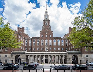
Penobscot County is a county in the U.S. state of Maine, named for the Penobscot people in Wabanakik. As of the 2020 census, the population was 152,199, making it the third-most-populous county in Maine. Its county seat is Bangor. The county was established on February 15, 1816, from part of Hancock County when the area was still part of Massachusetts. Penobscot County is home to the University of Maine.

<span class="mw-page-title-main">Bellevue, Idaho</span> City in Idaho, United States

Bellevue is a city in Blaine County in the central part of the U.S. state of Idaho. The population was 2,287 at the 2010 census, up from 1,876 in 2000.

<span class="mw-page-title-main">Bellevue, Iowa</span> City in Iowa, United States

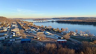
Bellevue is a city in eastern Jackson County, Iowa, United States. The city lies along the Mississippi River and next to Bellevue State Park. In 2020 its population was 2,363; up from a count of 2,191 at the 2010 Census, making it the second-largest and only growing city in Jackson County.

<span class="mw-page-title-main">La Motte, Iowa</span> City in Iowa, United States

La Motte is a small city in northern Jackson County, Iowa, United States. The population was 237 at the time of the 2020 census.

<span class="mw-page-title-main">Springbrook, Iowa</span> City in Iowa, United States

Springbrook is a small city in central Jackson County, Iowa, United States. The population was 143 at the time of the 2020 census.

<span class="mw-page-title-main">St. Donatus, Iowa</span> City in Iowa, United States

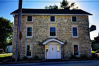
St. Donatus is a city in Jackson County, Iowa, United States. The population was 120 at the time of the 2020 census. St. Donatus is known for its status as a Luxembourger village, with historic architecture and views along U.S. Route 52. It is the home of a historic Catholic church, which is dedicated to Saint Donatus of Muenstereifel, the town's namesake. It was formerly named Tete Des Morts, which is the name of a creek that flows through the village.

<span class="mw-page-title-main">Bellevue, Michigan</span> Village in Michigan, United States

Bellevue is a village in Eaton County in the U.S. state of Michigan. The population was 1,282 at the 2010 census. The village is located within Bellevue Township.

<span class="mw-page-title-main">Bellevue, Nebraska</span> City in Sarpy County, Nebraska, United States

Bellevue is a suburban city in Sarpy County, Nebraska, United States. It is part of the Omaha–Council Bluffs metropolitan area, and had a population of 64,176 as of the 2020 census, making it the 3rd most populous city in Nebraska, behind Omaha and Lincoln, and the second largest city in the U.S. named "Bellevue," behind Bellevue, Washington.

<span class="mw-page-title-main">Mattawa, Washington</span> City in Washington, United States

Mattawa is an incorporated city in Grant County, Washington, United States. The population was 3,335 at the 2020 census.

<span class="mw-page-title-main">Beaux Arts Village, Washington</span> Town in Washington, United States

Beaux Arts is a town located in the Eastside region of King County, Washington, United States. It is the smallest municipality in the county, with a population of 317 as of the 2020 census and a land area of 0.1 sq mi.

<span class="mw-page-title-main">Clyde Hill, Washington</span> City in Washington, United States

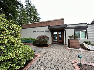
Clyde Hill is a city located in King County, Washington. It is part of the Eastside region, located to the east of Seattle, and is bordered by the cities and towns of Bellevue, Kirkland, Medina, Yarrow Point and Hunts Point. The population was 3,126 at the 2020 census.

<span class="mw-page-title-main">Eastgate, Bellevue</span> Neighborhood in King, Washington, United States

Eastgate is a neighborhood of Bellevue, Washington, United States. The population was 4,958 at the 2010 census. It was annexed by Bellevue in 2012.

<span class="mw-page-title-main">Hunts Point, Washington</span> Town in Washington, United States

Hunts Point is a town in the Eastside, a region of King County, Washington, United States, and part of the Seattle metropolitan area. The town is on a small peninsula surrounded by Lake Washington, and is near the suburbs of Medina, Clyde Hill, Yarrow Point, and Kirkland, as well as the city of Bellevue. As of the 2020 census, the town had a total population of 457.

<span class="mw-page-title-main">Medina, Washington</span> City in Washington, United States

Medina is a city in the Eastside region of King County, Washington, United States. The mostly residential city is on a peninsula in Lake Washington, on the opposite shore from Seattle, bordered by Clyde Hill and Hunts Point to the east and water on all other sides. The city's population was 2,915 at the 2020 census. Bill Gates and Jeff Bezos, along with a number of billionaires and executives for tech companies, have homes in Medina.

<span class="mw-page-title-main">Newcastle, Washington</span> City in Washington, United States

Newcastle is an Eastside city in King County, Washington, United States. The population was 13,017 at the 2020 census.

<span class="mw-page-title-main">Steilacoom, Washington</span> Town in Washington, United States

Steilacoom is a town in Pierce County, Washington, United States. The population was 6,727 at the 2020 census. Steilacoom incorporated in 1854 and became the first incorporated town in what is now the state of Washington. It has also become a bedroom community for service members stationed at Joint Base Lewis–McChord, aka McChord AFB and Fort Lewis.

<span class="mw-page-title-main">Bellevue, Wisconsin</span> Village in Wisconsin, United States

Bellevue is a village in Brown County, Wisconsin. It was a town until incorporating as a village on February 14, 2003. The population was 15,935 at the time of the 2020 census. Bellevue is part of the Green Bay metropolitan area. Bellevue sits around 4.34 miles (6.99 km) east from central Green Bay.

<span class="mw-page-title-main">Bellevue, Ohio</span> City in Ohio, United States

Bellevue is a city in Erie, Huron, Seneca, and Sandusky counties in the U.S. state of Ohio, located 61 miles southwest of Cleveland and 45 miles southeast of Toledo. The population was 8,249 at the 2020 census. The National Arbor Day Foundation has designated Bellevue as a Tree City USA.

References

  1. "Town Mayor and Council". Town of Yarrow Point. Retrieved March 26, 2022.
  2. "2019 U.S. Gazetteer Files". United States Census Bureau. Retrieved August 7, 2020.
  3. "Census Bureau profile: Yarrow Point, Washington". United States Census Bureau. May 2023. Retrieved March 13, 2024.
  4. "Yarrow Point". Geographic Names Information System . United States Geological Survey, United States Department of the Interior.
  5. Neiwert, David (2005). Strawberry Days . Palgrave Macmillan. p.  28. ISBN   978-1403967923.
  6. Hitchman, Robert (1985). Place Names of Washington. Washington State Historical Society. p. 339. ISBN   0-917048-57-1.
  7. "US Gazetteer files 2010". United States Census Bureau . Retrieved December 19, 2012.
  8. King County Elections
  9. "2016 General - Election Results by precinct (Complete eCanvass dataset) | King County | Open Data".
  10. "City and Town Population Totals: 2020-2021". United States Census Bureau. August 11, 2022. Retrieved August 11, 2022.
  11. United States Census Bureau. "Census of Population and Housing" . Retrieved July 31, 2013.
  12. "U.S. Census website". United States Census Bureau . Retrieved December 19, 2012.
  13. U.S. Census Bureau Geography Division (December 21, 2020). 2020 Census – School District Reference Map: King County, WA (PDF) (Map). 1:80,000. U.S. Census Bureau. p. 2. Retrieved August 3, 2022.
  14. "Bellevue School District Elementary School Attendance Area (2019)" (PDF). Bellevue School District . Retrieved August 3, 2022.
  15. "Bellevue School District Middle School Attendance Area (2019)" (PDF). Bellevue School District . Retrieved August 3, 2022.
  16. "Bellevue School District High School Attendance Area (2019)" (PDF). Bellevue School District . Retrieved August 3, 2022.
  17. Casey McNerthney (November 16, 2016). "Presidents of the United States of America - band behind 'Lump' and 'Peaches' - announces retirement". KIRO-TV.