Related Research Articles

Le Sueur County is a county located in the south central portion of the U.S. state of Minnesota. As of the 2020 census, the population was 28,674. Its county seat is Le Center.
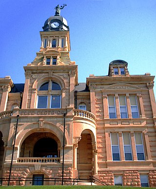
Blue Earth County is a county in the State of Minnesota. As of the 2020 census, the population was 69,112. Its county seat is Mankato. The county is named for the Blue Earth River and for the deposits of blue-green clay once evident along the banks of the Blue Earth River.

Conoy Township is a township in northwestern Lancaster County, Pennsylvania, United States. At the 2020 census, the population was 3,373.
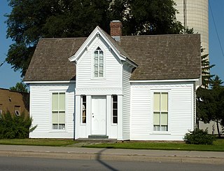
Le Center is a city in Le Sueur County, Minnesota, United States. The population was 2,517 at the 2020 census. It is the county seat of Le Sueur County. The Le Sueur County Courthouse and Jail are listed on the National Register of Historic Places.

Anthony Township is a township in Montour County, Pennsylvania, United States.
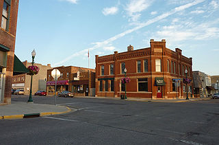
Le Sueur is a city in Le Sueur County in the U.S. state of Minnesota, between Mankato and the Twin Cities. It lies along the Minnesota River and U.S. Highway 169. Le Sueur was named in honor of the French explorer Pierre-Charles Le Sueur. The population was 4,213 at the 2020 census.

Charles Alexandre Lesueur was a French naturalist, artist, and explorer. He was a prolific natural-history collector, gathering many type specimens in Australia, Southeast Asia, and North America, and was also responsible for describing numerous species, including the spiny softshell turtle, smooth softshell turtle, and common map turtle. Both Mount Lesueur and Lesueur National Park in Western Australia are named in his honor.
Youngs Corner is an unincorporated community in Brookville Township, Franklin County, Indiana, United States.
Amador Valley is a valley in eastern Alameda County, California and is the location of the cities of Dublin and Pleasanton. Part of Tri-Valley, the valley is bounded by the foothills of the Diablo Range on the north and south, Pleasanton Ridge to the west, and Livermore Valley to the east.
Jerusalem Corners is a hamlet in the town of Evans in Erie County, New York, United States.
Sunny Side is an unincorporated community in Buckingham and Cumberland counties, in the U.S. state of Virginia. Sunny Side was a stop on the Farmville and Powhatan Railroad from 1884 to 1905 and then on the Tidewater and Western Railroad from 1905 to 1917. It is on the new Virginia State Route 13 between Powhatan, Virginia and Cumberland, Virginia from 1918 to today.
Allenslevel is an unincorporated community in Buckingham County, in the U.S. state of Virginia.
Andersonville is an unincorporated community in Buckingham County, in the U.S. state of Virginia.
Curdsville is an unincorporated community in Buckingham County, in the U.S. state of Virginia.
Mount Vinco is an unincorporated community in Buckingham County, in the U.S. state of Virginia.
Nuckols is an unincorporated community in Buckingham County, in the U.S. state of Virginia.
Rosney is an unincorporated community in Buckingham County, in the U.S. state of Virginia.
Jeffry Cliff Petroglyphs (15HA114) are prehistoric petroglyphs created by Native Americans, that lived in the western region of what is now the U.S. state of Kentucky. They are located on and around Jeffry Cliff in Hancock County, although the address is restricted. The petroglyphs cover a roughly 9-acre (0.036 km2) area and are open to public access. These petroglyphs were designated a National Historical Site by the National Park Service on September 8, 1989, and were subsequently assigned the reference number 89001191. The petroglyphs appear to be created for several purposes that include art, religion, and engineering.
Oakton is an unincorporated community in Barton County, in the U.S. state of Missouri.
References
Municipalities and communities of Buckingham County, Virginia, United States | ||
|---|---|---|
| Town |  | |
| CDPs | ||
| Unincorporated communities |
| |
| Footnotes | ‡This populated place also has portions in an adjacent county or counties | |
37°40′59″N78°21′15″W / 37.68306°N 78.35417°W
| | This Buckingham County, Virginia state location article is a stub. You can help Wikipedia by expanding it. |