
Buildings, sites, districts, and objects in Virginia listed on the National Register of Historic Places:
Union Corner is an unincorporated community in Berkeley County, West Virginia, United States.
Owens is a small unincorporated crossroads community at the intersection of Dahlgren Road, Windsor Drive, and Owens Drive in King George County, Virginia, United States. State Routes 206 and 218 meet at this intersection, with 206 going east towards U.S. Route 301 and Dahlgren, 218 going south towards US 301 and Colonial Beach and 206 and 218 joined together going west towards Arnolds Corner and Fredericksburg. The eastern part of the community is within the Dahlgren census-designated place.

Jefferson Rock is a rock formation on the Appalachian Trail in Harpers Ferry, West Virginia. It consists of several large masses of Harpers shale, piled one upon the other, that overlook the Shenandoah River just prior to its confluence with the Potomac River. It was added to the National Register of Historic Places as a contributing property of the Harpers Ferry National Historical Park on October 15, 1966.
This is a list of the National Register of Historic Places listings in Augusta County, Virginia.

This is a list of the National Register of Historic Places listings in Botetourt County, Virginia.

This is a list of the National Register of Historic Places listings in Fluvanna County, Virginia.
Wakefield Corner is an unincorporated community in Westmoreland County, in the U. S. state of Virginia.
This is a list of the National Register of Historic Places listings in Fredericksburg, Virginia.

This is a list of the National Register of Historic Places listings in Madison County, Virginia.
This is a list of the National Register of Historic Places listings in Newport News, Virginia.

This is a list of the National Register of Historic Places listings in Lee County, Virginia.

Hunts Corners is an unincorporated community in southeastern Lyme Township, Huron County, Ohio, United States. It lies at the intersection of State Route 547 and Sand Hill Road, southeast of Bellevue and southwest of the city of Norwalk, the county seat of Huron County. Its elevation is 768 feet (234 m), and it is located at 41°13′39″N82°45′27″W.
Farnham is an unincorporated community in Richmond County, in the U.S. state of Virginia.
Simons Corner is an unincorporated community in Richmond County, in the U.S. state of Virginia.
Oak Corner is an unincorporated community in Caroline County, in the U.S. state of Virginia.

Atkins Park is an intown neighborhood of Atlanta, Georgia, nestled against the southeast corner of the neighborhood of Virginia-Highland, west of Briarcliff Avenue and north of Ponce de Leon Avenue ("Ponce"). It consists of just three streets - St. Louis Place, St. Charles Place, and St. Augustine Place - as well as an internal sidewalk known as Malcolm's Way that bisects them from St. Charles to St. Louis. It was originally designed to give quicker access to the streetcar stop at Ponce.
This is a list of the National Register of Historic Places listings in Braxton County, West Virginia.
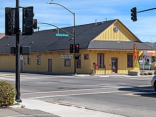
The Virginia & Truckee (V&T) Railroad Depot of Carson City, Nevada is a historic railroad station that is listed on the U.S. National Register of Historic Places (NRHP). It is significant for its association with the economically important role of the V&T railroad historically in Carson City following discovery of the Comstock Lode mine in 1859. To a lesser degree, according to its NRHP nomination, the depot building is also significant architecturally "as a well-preserved example of a wood-frame passenger depot procured from a railroad company pattern book within the V&T's former sphere of operation."
The National Register Information System (NRIS) is a database of properties that have been listed on the United States National Register of Historic Places. The database includes more than 84,000 entries of historic sites that are currently listed on the National Register, that were previously listed and later removed, or that are pending listing. The database includes approximately 45 pieces of data for each listed property. Accuracy of the NRIS database may be imperfect. For example, a 2004 paper addressed accuracy of spatial location data for part of the NRIS content.


