Saint Croix is an island in the Caribbean Sea, and a county and constituent district of the United States Virgin Islands (USVI), an unincorporated territory of the United States.

Exuma is a district of The Bahamas, consisting of over 365 islands, also called cays.
Jardines de la Reina is an archipelago in the southern part of Cuba, in the provinces of Camagüey and Ciego de Ávila.

Havensight on Saint Thomas in the U.S. Virgin Islands is a community and the busiest cruise ship port in the world. It is located in the Southside census subdistrict (CSD), 1.5 miles from the territorial capital of Charlotte Amalie. Havensight is mostly known for its deepwater port West Indian Company Dock, but is also known for its aerial tramway to Paradise Point on Flag Hill, the Havensight Mall, and many available ocean- and boat trips. The community is home a variety of companies offering boat trips, submarine rides, scuba diving, jet skiing, snorkeling, and more. There are also boat trips available to Red Hook in East End, Saint John, and Water Island.

Hol Chan Marine Reserve is a marine reserve close to Ambergris Caye and Caye Caulker, off the coast of Belize. It covers approximately 18 km² (4,448 acres) of coral reefs, seagrass beds, and mangrove forest. Hol Chan is Mayan for "little channel".

The Florida Reef is the only living coral barrier reef in the continental United States. It lies a few miles seaward of the Florida Keys, is about 4 miles wide and extends 270 km (170 mi) from Fowey Rocks just east of Soldier Key to just south of the Marquesas Keys. The barrier reef tract forms a great arc, concentric with the Florida Keys, with the northern end, in Biscayne National Park, oriented north-south and the western end, south of the Marquesas Keys, oriented east-west. The rest of the reef outside Biscayne National Park lies within John Pennekamp Coral Reef State Park and the Florida Keys National Marine Sanctuary. Isolated coral patch reefs occur northward from Biscayne National Park as far north as Stuart, in Martin County. Coral reefs are also found in Dry Tortugas National Park west of the Marquesas Keys. There are more than 6,000 individual reefs in the system. The reefs are 5,000 to 7,000 years old, having developed since sea levels rose following the Wisconsinan glaciation.

The Maldives, officially the Republic of Maldives, is a small archipelagic state in South Asia. It lies in the Indian Ocean southwest of Sri Lanka and India, about 700 kilometres (430 mi) from the Asian continent's mainland. The chain of 26 atolls stretches across the Equator from Ihavandhippolhu Atoll in the north to Addu Atoll in the south. The land area is roughly 298 square kilometres. Malé is the capital.

Bunaken National Park is a marine park in the north of Sulawesi island, Indonesia. The park is located near the centre of the Coral Triangle, providing habitat to 390 species of coral as well as many fish, mollusc, reptile and marine mammal species. The park is representative of Indonesian tropical water ecosystems, consisting of seagrass plain, coral reef, and coastal ecosystems.

The Prickly Pear Cays, sometimes spelt as Prickley Pear Cays, are a small pair of uninhabited islands about six miles from Road Bay, Anguilla, in the Leeward Islands of the Caribbean. They are divided by a narrow boat channel between Prickly Pear East and Prickly Pear West. Prickly Pear Cays were classified as 'wildlands' by the "Eastern Caribbean Natural Area Management Programme" (ECNAMP). In addition, Prickly Pear Cays are one of six marine protected areas of Anguilla.
Chub Cay is an island in the Berry Islands chain of the Bahamas. It has a population of 46.

The fauna of the United States Virgin Islands consists of 144 species of birds, 22 species of mammals, 302 species of fish and 7 species of amphibians. The wildlife of the U.S.V.I. includes numerous endemic species of tropical birds, fish, and land reptiles as well as sea mammals. The only endemic land mammals are six species of native bats: the greater bulldog bat, Antillean fruit-eating bat, red fruit bat, Brazilian free-tailed bat, velvety free-tailed bat and the Jamaican fruit bat. Some of the nonnative land mammals roaming the islands are the white-tailed deer, small Asian mongoose, goats, feral donkeys, rats, mice, sheep, hogs, dogs and cats.
Saba Island is a rocky Caribbean island in the United States Virgin Islands, situated three miles south of Cyril E. King Airport on St. Thomas and 2.6 miles west of Water Island. It is a steep, 200 feet high island with a sandy beach on the northern side. Turtledove Cay is connected by a shallow sandbar. Saba Island has salt ponds on both the eastern and western sides, which is popular bird observation posts, and has numerous rocky cliffs with sea birds on its southern shores. Besides for bird observation, the island is visited by scuba divers and snorkelers. In addition to coral reefs, the waters here are home to numerous ship wrecks, such as the Witshoal II, Witconcrete II, Grainton, and Witservice IV.
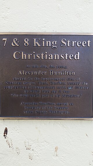
Protestant Cay is a four-acre triangular islet in the Christiansted Harbor, 200 yards north of Christiansted. The island is home to a resort, the Hotel on the Cay, which is home to a protected sand beach, small shop and beach bar. It also has the closest beach to Downtown Christiansted. With one of the ferries, which run from 7 a.m. to 12 a.m., every ten minutes, it will only take about two minutes to get there. The ride is free of charge after 4 p.m., and for guests of the Hotel on the Cay. To get on the ferry, passengers have to stand near the boardwalk in front of the King Christian Hotel and wave to the boat captain on duty.

Cas Cay is a fifty-acre (200,000-square-metre) undeveloped island, situated a mile south of Red Hook on the eastern side of Saint Thomas in the United States Virgin Islands. It is under the protection of the Department of Natural Resources. Ferries here depart from Compass Point Marina, right east of Nadir.

Steven Cay is a small scrub-covered and rocky Caribbean island, about 28 feet high and situated 0.5 miles west of Cruz Bay on Saint John in the United States Virgin Islands. It is a popular destination for snorkelers and scuba divers,.

Whistling Cay is a 19-acre (7.7 ha) islet, situated 300 yards (270 m) west of Mary Point on Saint John in the United States Virgin Islands. It is covered with trees and high cliffs in the north, where it reaches a 130-foot (40 m) elevation. A gravel beach is located on the southeast side of the island. It is separated from Saint John by the Fungi Passage, which has a depth of 21 feet (6.4 m).
Cinnamon Cay is a cay in the United States Virgin Islands, situated approximately 0.7 miles east of Trunk Cay in the Cinnamon Bay, and 100 yards from the shore at Cinnamon Bay Beach on Saint John island. It has a height of 32 feet. The islet is uninhabited, but regularly visited by scuba-divers, snorkelers and kayakers. Cinnamon Bay Watersports offers kayaks and snorkeling equipment for travelers to the cay. Cinnamon Cay is mostly covered with grass and cactus, and is located within the Virgin Islands National Park.

East End is an administrative subdistrict of the island of St. Thomas in the United States Virgin Islands. The largest community is Red Hook, while smaller communities include Benner, Nazareth, Nadir, Frydendal, and Smith Bay. The subdistrict includes the offshore islands of Great Saint James, Little Saint James, Bovoni Cay, Patricia Cay, Cas Cay, Rotto Cay, Thatch Cay, Shark Island, and Dog Island.
Staniel Cay is an island located in The Exuma Cays, a district of The Bahamas.

Lighthouse Reef is an atoll in the Caribbean Sea, the easternmost part of the Belize Barrier Reef and one of its three atolls, the other two being Turneffe Atoll and Glover's Reef. Lighthouse Reef is located about 80 kilometres (50 mi) southeast of Belize City. The atoll is of oblong shape, approximately 35 kilometres (22 mi) long from north to south, and about 8 kilometres (5.0 mi) wide. It forms a shallow sandy lagoon with an area of 120 square kilometres (46 sq mi) and a depth between 2 and 6 metres deep.


