Lind, Washington

Last updated

Lind
Lind, Washington
East 2nd Avenue in downtown Lind, WA.jpg
East 2nd Avenue in Lind
Adams County Washington Incorporated and Unincorporated areas Lind Highlighted.svg
Location of Lind, Washington
Coordinates: 46°58′21″N118°36′59″W / 46.97250°N 118.61639°W / 46.97250; -118.61639
Country United States
State Washington
County Adams
Area
[1]
  Total1.10 sq mi (2.86 km2)
  Land1.10 sq mi (2.86 km2)
  Water0.00 sq mi (0.00 km2)
Elevation
1,368 ft (417 m)
Population
 (2020) [2]
  Total535
  Density509.50/sq mi (196.81/km2)
Time zone UTC-8 (Pacific (PST))
  Summer (DST) UTC-7 (PDT)
ZIP code
99341
Area code 509
FIPS code 53-39510
GNIS feature ID1512391 [3]
Website lindwa.com

Lind is a town in Adams County, Washington, United States. The population was 535 at the 2020 census, a 5.1% decrease over the preceding census.

Contents

History

Lind was first settled in 1888 on a relatively barren area along the Northern Pacific Railway's main line by the Neilson Brothers, James and Dugal. The site had previously been selected in 1881 for a station (an old boxcar) and section house and was named Lind by the railroad although the exact origin of that name has been lost. [4] In the autumn of 1888 the Neilson Brothers built the first Lind residence and two years later they built and stocked a store and resumed postal service which until then had been processed in Ritzville and tossed off in town by passing trains. James Neilson became the first postmaster. The first school opened in 1889 with six students in attendance. The Neilson Brothers platted the town site on June 7, 1890, which consisted of only four square blocks. The Panic of 1893 would stave off any further development of the town site until the turn of the century. [5]

By 1899 the panic was starting to wear off and the local wheat crop, of high quality, was growing in demand. Lind began to expand in size. A new post office and saloon were built and a lumber yard was started and by the end of the year, the population was nearing 100. By the end of 1901, several brick buildings were being constructed for a bank and other stores and hundreds of temporary dwellings were constructed by settlers. A new school and three churches were built. Between 1898 and 1903, Lind grew immensely to a population of about 600 and saw the opening of many more stores, restaurants, a second bank, real estate offices and a newspaper, The Lind Leader. Lind was incorporated on January 26, 1902. Dugal Neilson was elected mayor while his brother James was elected treasurer. [5]

The Milwaukee Road would later lay its tracks through the south side of town, which is now the John Wayne Pioneer Trail.

When the Neilson brothers platted the town site of Lind, they named all of the north to south streets to eventually spell out their surname. The town only grew large enough to spell "Neilso".

The local Jr./Sr. High School has changed mascots many times some of which are Lind Bulldogs, Lind-Kahlotus Blue Devils, Lind-Ritzville Broncos, and the current Lind-Ritzville-Sprague Broncos which is classified as a 2B school according to the WIAA. Old time rival the Rearden Indians has been kept, but due to the great success with the local football program, it has been the very challenging Colfax Bulldogs. Also, due to state funding, the local high school will move to the nearby town of Ritzville, WA. The middle school remains at Lind as same with Ritzville. [4]

On August 4, 2022, the entire town was ordered to evacuate due to an approaching wildfire, which destroyed 10 homes. [6] Local highways were also shut down while firefighters moved into the area to control the wildfire. [7]

Lind, Washington panorama (1906).jpg
Lind, 1906

Geography

Lind is located near the geographical center of Adams County. It is situated within the shallow Lind Coulee, which forms part of the border between a rich agricultural region and the Channeled Scablands and just east of where the Paha and McElroy Coulees branch off to the north. Lind is located 5 miles west of Highway 395 where it intersects with Lind - Ralston and Lind - Kahlotus road, officially known as SR 21, in an area known as East Lind on maps, located at the base of the Paha Coulee. from the east, SR 21 passes through the center of town by becoming East 2nd Avenue then turning left on to North I Street then right onto North 1st Street. As the highway turns north, Lind - Hatton and Lind - Warden Roads branch off to the west.

According to the United States Census Bureau, the town has a total area of 1.07 square miles (2.77 km2), all of it land. [8]

Climate

According to the Köppen Climate Classification system, Lind has a semi-arid climate, abbreviated "BSk" on climate maps. [9]

Climate data for Lind, Washington (1991–2020 normals, extremes 1931–present)
MonthJanFebMarAprMayJunJulAugSepOctNovDecYear
Record high °F (°C)62
(17)
67
(19)
76
(24)
92
(33)
100
(38)
114
(46)
111
(44)
113
(45)
102
(39)
91
(33)
72
(22)
62
(17)
114
(46)
Mean daily maximum °F (°C)37.8
(3.2)
44.3
(6.8)
54.0
(12.2)
62.5
(16.9)
72.4
(22.4)
79.2
(26.2)
89.2
(31.8)
88.2
(31.2)
78.6
(25.9)
62.9
(17.2)
46.6
(8.1)
36.7
(2.6)
62.7
(17.1)
Daily mean °F (°C)32.1
(0.1)
36.6
(2.6)
43.5
(6.4)
49.7
(9.8)
57.8
(14.3)
64.0
(17.8)
71.9
(22.2)
71.2
(21.8)
62.7
(17.1)
50.3
(10.2)
38.8
(3.8)
31.3
(−0.4)
50.8
(10.4)
Mean daily minimum °F (°C)26.5
(−3.1)
28.9
(−1.7)
33.0
(0.6)
36.9
(2.7)
43.1
(6.2)
48.7
(9.3)
54.6
(12.6)
54.2
(12.3)
46.8
(8.2)
37.7
(3.2)
31.0
(−0.6)
25.8
(−3.4)
38.9
(3.8)
Record low °F (°C)−26
(−32)
−22
(−30)
1
(−17)
11
(−12)
20
(−7)
29
(−2)
32
(0)
32
(0)
22
(−6)
4
(−16)
−16
(−27)
−20
(−29)
−26
(−32)
Average precipitation inches (mm)1.29
(33)
0.88
(22)
1.05
(27)
0.83
(21)
0.86
(22)
0.69
(18)
0.34
(8.6)
0.24
(6.1)
0.34
(8.6)
0.92
(23)
1.29
(33)
1.40
(36)
10.13
(257)
Average snowfall inches (cm)6.5
(17)
2.0
(5.1)
0.7
(1.8)
0.1
(0.25)
0.0
(0.0)
0.0
(0.0)
0.0
(0.0)
0.0
(0.0)
0.0
(0.0)
0.0
(0.0)
1.1
(2.8)
4.2
(11)
14.6
(37)
Average precipitation days (≥ 0.01 in)11.08.08.16.86.54.92.12.02.96.711.111.181.2
Average snowy days (≥ 0.1 in)3.31.80.60.10.00.00.00.00.00.01.04.010.8
Source: NOAA [10] [11]

Demographics

Historical population
CensusPop.Note
1910 831
1920 724−12.9%
1930 7300.8%
1940 679−7.0%
1950 79617.2%
1960 697−12.4%
1970 622−10.8%
1980 567−8.8%
1990 472−16.8%
2000 58223.3%
2010 564−3.1%
2020 535−5.1%
U.S. Decennial Census [12] [13]

2020 census

As of the census [14] of 2020 there were 535 people, 182 households, and 108 families residing in the town. The population density was 478.9 inhabitants per square mile (184.9/km2). The racial makeup of the town was 86.6% White, 0.8% Native American, and 12.6% from two or more races.

There were 182 households, of which 31.3% had children under the age of 18 living with them, 37.9% were married couples living together, 21.4% had a male householder with no spouse present, and 40.7% were non-families. 26.9% of all households were made up of individuals, and 12.1% had someone living alone who was 65 years of age or older. The average household size was 2.8 and the average family size was 3.12.

The median age in the town was 32.4 years. 24.8% of residents were under the age of 18; 11.6% were between the ages of 18 and 24; 21.2% were from 25 to 44; 30.6% were from 45 to 64; and 11.8% were 65 years of age or older. The gender makeup of the town was 47.9% male and 52.1% female.

2010 census

As of the 2010 census, [15] there were 564 people, 234 households, and 151 families residing in the town. The population density was 527.1 inhabitants per square mile (203.5/km2). There were 276 housing units at an average density of 257.9 per square mile (99.6/km2). The racial makeup of the town was 87.9% White, 1.6% African American, 1.4% Asian, 6.4% from other races, and 2.7% from two or more races. Hispanic or Latino of any race were 11.2% of the population.

There were 234 households, of which 28.2% had children under the age of 18 living with them, 46.6% were married couples living together, 13.2% had a female householder with no husband present, 4.7% had a male householder with no wife present, and 35.5% were non-families. 29.1% of all households were made up of individuals, and 13.7% had someone living alone who was 65 years of age or older. The average household size was 2.41 and the average family size was 2.98.

The median age in the town was 43.1 years. 24.1% of residents were under the age of 18; 9.6% were between the ages of 18 and 24; 18.6% were from 25 to 44; 29.5% were from 45 to 64; and 18.1% were 65 years of age or older. The gender makeup of the town was 51.2% male and 48.8% female.

2000 census

As of the 2000 census, there were 582 people, 230 households, and 161 families residing in the town. The population density was 566.3 people per square mile (218.2/km2). There were 307 housing units at an average density of 298.7 per square mile (115.1/km2). The racial makeup of the town was 90.89% White, 0.52% Native American, 0.17% Asian, 7.22% from other races, and 1.20% from two or more races. Hispanic or Latino of any race were 11.86% of the population.

There were 230 households, out of which 33.9% had children under the age of 18 living with them, 57.0% were married couples living together, 8.7% had a female householder with no husband present, and 29.6% were non-families. 27.0% of all households were made up of individuals, and 13.9% had someone living alone who was 65 years of age or older. The average household size was 2.53 and the average family size was 3.05.

In the town, the age distribution of the population shows 29.6% under the age of 18, 4.5% from 18 to 24, 26.3% from 25 to 44, 22.7% from 45 to 64, and 17.0% who were 65 years of age or older. The median age was 38 years. For every 100 females, there were 100.0 males. For every 100 females age 18 and over, there were 91.6 males.

The median income for a household in the town was $40,147, and the median income for a family was $40,938. Males had a median income of $33,625 versus $18,000 for females. The per capita income for the town was $16,948. About 8.2% of families and 11.5% of the population were below the poverty line, including 18.3% of those under age 18 and 4.1% of those age 65 or over.

Arts and culture

Lind is the home of a combine demolition derby that is held annually in June. It has received much publicity over the past couple years when it was featured in Playboy's 50th Year Anniversary Special Edition issue, Discovery Channel, the movie "Always", Hamish and Andy (Australia), ESPN, KHQ's "The Derby", and also in Stranger Than Fiction: True Stories by Chuck Palahniuk. It has also been featured on CMT. Lind also is surrounded by fields of wheat. About half are owned by Russian-German Mennonite and Hutterites farmers.

Related Research Articles

<span class="mw-page-title-main">Adams County, Washington</span> County in Washington, United States

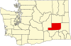
Adams County is a county in the U.S. state of Washington. As of the 2020 census, the population was 20,613. The county seat is at Ritzville, and its largest city is Othello. The county was formed out of Whitman County in November 1883 and is named after John Adams, the second President of the United States.

<span class="mw-page-title-main">St. Agatha, Maine</span> Town in the state of Maine, United States

St. Agatha is a town in Aroostook County, Maine, United States. The population was 730 at the 2020 census.

Talmadge is a town in Washington County, Maine, United States. The town was named after landowner Benjamin Tallmadge. The population was 70 at the 2020 census.

<span class="mw-page-title-main">Morton, Minnesota</span> City in Minnesota, United States

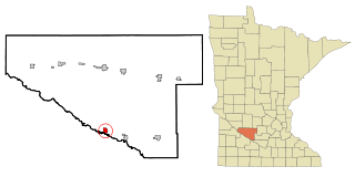
Morton is a city in Renville County, Minnesota, United States. This city is ninety-five miles southwest of Minneapolis. It is the administrative headquarters of the Lower Sioux Indian Reservation. The population was 411 at the 2010 census.

<span class="mw-page-title-main">Hatton, Washington</span> Town in Washington, United States

Hatton is a small incorporated town in Adams County, Washington, United States. The population was 79 at the 2020 census.

<span class="mw-page-title-main">Ritzville, Washington</span> City in Washington, United States

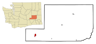
Ritzville is a city in Adams County, Washington, United States. The population was 1,767 at the 2020 census. It is the county seat of Adams County. The city is part of the Othello, WA Micropolitan Area, which comprises all of Adams County, and is part of the larger Moses Lake-Othello, WA Combined Statistical Area.

<span class="mw-page-title-main">Washtucna, Washington</span> Town in Washington, United States

Washtucna is a town in Adams County, Washington, United States. The population was 211 at the 2020 census, a 1% increase over the previous census. The town was named for a lake 12 miles from the town in Franklin County which was in turn named after a Palouse Native American chief.

<span class="mw-page-title-main">Connell, Washington</span> City in Washington, United States

Connell is a city in Franklin County, Washington, United States. The population was 5,441 at the 2020 census.

<span class="mw-page-title-main">Mesa, Washington</span> City in Washington, United States

Mesa is a city in Franklin County, Washington, United States. The population was 489 at the 2010 census. The Washington State Office of Financial Management's 2018 estimate placed the population at 513.

<span class="mw-page-title-main">Banks Lake South, Washington</span> Census-designated place in Washington, United States

Banks Lake South is a census-designated place (CDP) in Grant County, Washington, United States. The population was 174 at the 2010 census.

<span class="mw-page-title-main">Coulee City, Washington</span> Town in Washington, United States

Coulee City is a town in Grant County, Washington. The population was 549 at the 2020 census.

<span class="mw-page-title-main">Electric City, Washington</span> City in Washington, United States

Electric City is a city in Grant County, Washington. The population was 956 at the time of the 2020 census. The community was named for its proximity to the power source at Grand Coulee Dam.

<span class="mw-page-title-main">Grand Coulee, Washington</span> City in Washington, United States

Grand Coulee is a city in Grant County, Washington, United States. The population was 972 at the 2020 census.

<span class="mw-page-title-main">Hartline, Washington</span> Town in Washington, United States

Hartline is a town in Grant County, Washington, United States. The population was 180 at the 2020 census. The high school for the Almira-Coulee/Hartline school district was located here, but moved to Coulee City, Washington in 2008. The name "Hartline" is an Americanized spelling of the German last name "Hartlein" and is an uncommon last name.

<span class="mw-page-title-main">Reardan, Washington</span> Town in Washington, United States

Reardan is a town in Lincoln County, Washington, United States. The population was 637 at the 2020 census.

<span class="mw-page-title-main">Marcus, Washington</span> Town in Washington, United States

Marcus is a town in Stevens County, Washington, United States. The population was 117 at the 2000 census and 183 at the 2010 census, a 56.4% increase over the 2000 census.

<span class="mw-page-title-main">Rhodell, West Virginia</span> Unincorporated community in West Virginia, United States

Rhodell is an unincorporated community in Raleigh County, West Virginia, United States. The population was 173 at the 2010 census.

<span class="mw-page-title-main">Coulee Dam, Washington</span> Town in Washington, United States

Coulee Dam is a town in Douglas, Grant, and Okanogan counties in the state of Washington. The Douglas County portion of Coulee Dam is part of the Wenatchee–East Wenatchee Metropolitan Statistical Area. The population was 1,211 as of the 2020 census.

Grantsburg is a town in Burnett County in the U.S. state of Wisconsin. The population was 1,136 at the 2010 census. The village of Grantsburg is located within the town. The unincorporated communities of Branstad and Lind are located in the town.

<span class="mw-page-title-main">East Millinocket, Maine</span> Town in the state of Maine, United States

East Millinocket is a town in Penobscot County, Maine, United States. The population was 1,572 at the 2020 census.

References

  1. "2019 U.S. Gazetteer Files". United States Census Bureau. Retrieved August 7, 2020.
  2. "2020 United States Census". United States Census Bureau. Retrieved August 6, 2022.
  3. "US Board on Geographic Names". United States Geological Survey. October 25, 2007. Retrieved January 31, 2008.
  4. 1 2 Phillips, James W. Washington State Place Names. 8th ed. Seattle: University of Washington Press, 1971. One local story has it that the town was named after Jenny Lind, the Swedish Nightingale, who came through the town on the train, but Jenny finished her American tour in 1852 and went to London that year, long before the train line was built, and died in 1887. Print.
  5. 1 2 An Illustrated History of The Big Bend Country, Embracing Lincoln, Douglas, Adams and Franklin Counties. Spokane, Washington: Western Historical Publishing Company, 1904. Print.
  6. Utter, Joe (August 4, 2022). "State mobilization approved for 2,000-acre Lind fire". iFiberOne News. Retrieved August 4, 2022.
  7. "Washington town told to leave due to wildfire, homes lost". The Seattle Times. Associated Press. August 4, 2022. Retrieved August 4, 2022.
  8. "US Gazetteer files 2010". United States Census Bureau. Archived from the original on July 2, 2012. Retrieved December 19, 2012.
  9. Climate Summary for Lind, Washington
  10. "NOWData - NOAA Online Weather Data". National Oceanic and Atmospheric Administration. Retrieved December 12, 2023.
  11. "Summary of Monthly Normals 1991-2020". National Oceanic and Atmospheric Administration. Retrieved December 12, 2023.
  12. United States Census Bureau. "Census of Population and Housing" . Retrieved October 3, 2013.
  13. United States Census Bureau. "Lind town, Washington" . Retrieved July 23, 2022.
  14. "U.S. Census Bureau Tables". United States Census Bureau . Retrieved August 6, 2022.
  15. "U.S. Census website". United States Census Bureau . Retrieved December 19, 2012.