List of Australian place names of Aboriginal origin

Last updated

Satellite view of Australia's capital city, Canberra, whose name comes from a Ngunawal language word meaning "meeting place". Canberra SPOT 1088.jpg
Satellite view of Australia's capital city, Canberra, whose name comes from a Ngunawal language word meaning "meeting place".

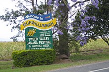
Welcome sign from Murwillumbah, New South Wales. The name derives from the Bandjalang word meaning "camping place". Murwillumbah sign.JPG
Welcome sign from Murwillumbah, New South Wales. The name derives from the Bandjalang word meaning "camping place".
Aboriginal names of suburbs of Brisbane, derived from the Turrbal language. Aboriginal Names Listing 03.jpg
Aboriginal names of suburbs of Brisbane, derived from the Turrbal language.

Place names in Australia have names originating in the Australian Aboriginal languages for three main reasons:[ citation needed ]

Contents

Watkin Tench, who arrived on the First Fleet in 1788, observed of the Aboriginal languages of the present-day Sydney area:

"We were at first inclined to stigmatise this language as harsh and barbarous in its sounds. Their combinations of words in the manner they utter them, frequently convey such an effect. But if not only their proper names of men and places, but many of their phrases and a majority of their words, be simply and unconnectedly considered, they will be found to abound with vowels and to produce sounds sometimes mellifluous and sometimes sonorous. What ear can object to the names of Colbee (pronounced exactly as Colby is with us), Bereewan, Bondel, Imeerawanyee, Deedora, Wolarawaree, or Baneelon, among the men; or to Wereeweea, Gooreedeeana, Milba, [1] or Matilba, among the women? Parramatta, Gweea, Cameera, Cadi, and Memel, are names of places. The tribes derive their appellations from the places they inhabit. Thus Cemeeragal, means the men who reside in the bay of Cameera; Cadigal, those who reside in the bay of Cadi; and so of the others. [2] "

Towns and suburbs

→A←

→B←

→C←

→D←

→E←

→G←

→H←

→I←

→J←

→K←

→L←

→M←

→N←

→O←

→P←

→Q←

→R←

→S←

→T←

→U←

→W←

→Y←

Regions and shires not named after town, river, etc.

Natural features

Islands

Mountains, ranges etc

Deserts

Caves

Borenore

Dams

Parks and forests

National parks

Nature reserves

State forests

State Conservation Areas

Highways and main roads

Non-Aboriginal place names that are assumed to be Aboriginal

Place names over which uncertainty exists

See also

Related Research Articles

<span class="mw-page-title-main">Wurundjeri</span> Aboriginal Australian people who inhabited the Melbourne area before colonisation

The Wurundjeripeople are an Australian Aboriginal people of the Woiwurrung language group, in the Kulin nation. They are the traditional owners of the Yarra River Valley, covering much of the present location of Melbourne. They continue to live in this area and throughout Australia. They were called the Yarra tribe by early European colonists.

<span class="mw-page-title-main">Yarra Ranges Shire</span> Local government area in Victoria, Australia

The Shire of Yarra Ranges, also known as Yarra Ranges Council, is a local government area in Victoria, Australia, located in the outer eastern and northeastern suburbs of Melbourne extending into the Yarra Valley and Dandenong Ranges. It has an area of 2,468 square kilometres (953 sq mi), of which 3% is classified as urban. In June 2018, it had a population of 158,173.

<span class="mw-page-title-main">Shire of Baw Baw</span> Local government area in Victoria, Australia

The Shire of Baw Baw is a local government area in Victoria, Australia, in the eastern part of the state. It covers an area of 4,028 square kilometres (1,555 sq mi) and in June 2018 had a population of 52,015.

<span class="mw-page-title-main">Shire of Mansfield</span> Local government area in Victoria, Australia

The Mansfield Shire is a local government area in the Hume region of Victoria, Australia, located in the north-east part of the state. It covers an area of 3,844 square kilometres (1,484 sq mi) and in June 2018, had a population of 8,979.

<span class="mw-page-title-main">Lysterfield, Victoria</span> Suburb of Melbourne, Victoria, Australia

Lysterfield is a suburb in Melbourne, Victoria, Australia, 32 km south-east of Melbourne's Central Business District, located within the City of Knox and the Shire of Yarra Ranges local government areas. Lysterfield recorded a population of 6,681 at the 2021 census.

<span class="mw-page-title-main">Belgrave, Victoria</span> Suburb of Melbourne, Victoria, Australia

Belgrave is a town and outer suburb in Melbourne, Victoria, Australia, 36 km east of Melbourne's central business district, located within the Shire of Yarra Ranges local government area. Belgrave recorded a population of 3,894 at the 2021 census.

<span class="mw-page-title-main">Sassafras, Victoria</span> Town in Victoria, Australia

Sassafras is a locality and township within Greater Melbourne, beyond the Melbourne metropolitan area Urban Growth Boundary, 43 km east of Melbourne's Central Business District, located within the City of Knox and Shire of Yarra Ranges local government areas. Sassafras recorded a population of 970 at the 2021 census.

<span class="mw-page-title-main">Victorian Alps</span>

The Victorian Alps, also known locally as the High Country, is a large mountain system in the southeastern Australian state of Victoria. Occupying the majority of eastern Victoria, it is the southwestern half of the Australian Alps, the tallest portion of the Great Dividing Range. The Yarra and Dandenong Ranges, both sources of rivers and drinking waters for Melbourne, are branches of the Victorian Alps.

<span class="mw-page-title-main">Daintree, Queensland</span> Town in Queensland, Australia

Daintree is a rural town and locality in the Shire of Douglas, Queensland, Australia. In the 2016 census, Daintree had a population of 129 people.

<span class="mw-page-title-main">Far North Queensland</span> Region in Queensland, Australia

Far North Queensland (FNQ) is the northernmost part of the Australian state of Queensland. Its largest city is Cairns and it is dominated geographically by Cape York Peninsula, which stretches north to the Torres Strait, and west to the Gulf Country. The waters of Torres Strait include the only international border in the area contiguous with the Australian mainland, between Australia and Papua New Guinea.

<span class="mw-page-title-main">Palmer River</span> River in Queensland, Australia

The Palmer River is a river in Far North Queensland, Australia. The area surrounding the river was the site of a gold rush in the late 19th century which started in 1873.

<span class="mw-page-title-main">Latrobe River</span> River in Victoria, Australia

The Latrobe River is a perennial river of the West Gippsland catchment, located in the West Gippsland region of the Australian state of Victoria. The Latrobe River and its associated sub-catchment is an important source for the Gippsland Lakes, draining the south eastern slopes of the Great Dividing Range.

<span class="mw-page-title-main">Mount Ommaney, Queensland</span> Suburb of Brisbane, Queensland, Australia

Mount Ommaney is a south-western riverside suburb in the City of Brisbane, Queensland, Australia. The mountain of the same name is located within the locality. In the 2016 census, Mount Ommaney had a population of 2,360 people.

<span class="mw-page-title-main">Bloomfield River</span> River in Far North Queensland, Australia

The Bloomfield River is a river in the Wet Tropics of Far North Queensland, Australia, noted for its Bloomfield River cod fish species, found only in the river.

Billibellary was a song maker and influential ngurungaeta of the Wurundjeri-willam clan during the early years of European settlement of Melbourne. He was known by various names including Billi-billeri, Billibellary, Jika Jika, Jacky Jacky and Jaga Jaga. He was an astute and diplomatic leader, described as powerfully built with an influence and reputation that extended well beyond his clan.

<span class="mw-page-title-main">Palmer, Queensland</span> Suburb of Shire of Cook, Queensland, Australia

Palmer is a rural locality in the Shire of Cook, Queensland, Australia. In the 2021 census, Palmer had a population of 46 people.

Congo is a village in Eurobodalla Shire on the South Coast of New South Wales. Congo is located 315 km south of Sydney, and 10 km south of Moruya.

<span class="mw-page-title-main">Mossman River</span> River in Far North Queensland, Australia

The Mossman River is a river in the Cape York Peninsula of Far North Queensland, Australia.

References

  1. Tench reports that: Mrs. Johnson, wife of the chaplain of the settlement, was so pleased with this name that she christened her little girl, born in Port Jackson, Milba Maria Johnson
  2. Watkin Tench, The Settlement of Port Jackson, Chapter 17. Archived 26 June 2007 at the Wayback Machine
  3. 1 2 3 4 5 6 7 8 9 10 11 12 13 14 15 16 17 18 19 20 21 22 23 24 25 26 27 28 29 30 31 32 33 34 35 36 37 38 39 40 41 42 43 44 45 46 47 48 49 50 51 52 53 54 55 56 57 58 59 60 61 62 63 64 65 66 67 68 69 70 71 72 73 74 75 76 77 78 79 80 81 82 83 84 85 86 87 88 89 90 91 92 93 94 95 96 97 98 99 100 101 102 103 104 105 106 107 108 109 110 111 112 113 114 115 116 117 118 119 120 121 122 123 124 125 126 127 128 129 130 131 132 133 134 135 136 137 138 139 140 141 142 143 144 145 146 147 148 149 150 151 152 153 154 155 156 157 158 159 160 161 162 163 164 165 166 167 168 169 170 171 172 173 174 175 176 177 178 179 180 181 182 183 184 185 186 187 188 189 190 191 192 193 194 195 196 197 198 199 200 201 202 203 204 205 206 207 208 209 210 211 212 213 214 215 216 217 218 219 220 221 222 223 224 225 226 227 228 229 230 231 232 233 234 235 236 237 238 239 240 241 242 243 244 245 246 247 248 249 250 251 252 253 254 255 256 257 258 259 260 261 262 263 264 265 266 267 268 269 270 271 272 273 274 275 276 277 278 279 280 281 282 283 284 285 286 287 288 "History of country town names". Landgate. n.d. Retrieved 31 December 2014.
  4. 1 2 3 4 5 6 7 8 9 10 11 12 13 14 15 16 17 18 19 20 21 22 23 24 25 26 27 28 29 30 31 32 33 34 35 36 37 38 39 40 41 42 43 44 45 46 47 48 49 50 51 52 53 54 55 56 57 58 59 60 61 62 63 "History of metropolitan suburb names". Landgate. n.d. Archived from the original on 19 May 2009. Retrieved 31 December 2014.
  5. "Goornong, VIC - 31 March 2019". 31 December 2018.
  6. "Wokalup". Shire of Harvey. n.d. Archived from the original on 6 December 2014. Retrieved 31 December 2014.