Cave Creek is a town in Maricopa County, Arizona, United States. It is part of the Phoenix metropolitan area. As of the 2020 census, the population of the town was 4,892.

Superstition Mountain is a prominent mountain and regional landmark located in the Phoenix metropolitan area of Arizona, immediately east of Apache Junction and north of Gold Canyon. It anchors the west end of the Superstition Mountains and is a popular outdoor recreation destination, home to numerous trails for hiking and horseback riding. The legend of the Lost Dutchman's Gold Mine centers around the mountain.

The Salt River is a river in Gila and Maricopa counties in Arizona, United States, that is the largest tributary of the Gila River. The river is about 200 miles (320 km) long. Its drainage basin covers about 13,700 square miles (35,000 km2). The longest of the Salt River's many tributaries is the 195-mile (314 km) Verde River. The Salt's headwaters tributaries, the Black River and East Fork, increase the river's total length to about 300 miles (480 km). The name Salt River comes from the river's course over large salt deposits shortly after the merging of the White and Black Rivers.
Indigenous peoples of Arizona are the Native American people who currently live or have historically lived in what is now the state of Arizona. There are 22 federally recognized tribes in Arizona, including 17 with reservations that lie entirely within its borders. Reservations make up over a quarter of the state's land area. Arizona has the third largest Native American population of any U.S. state.

The Apache Trail in Arizona was a stagecoach trail that ran through the Superstition Mountains. It was named the Apache Trail after the Apache Indians who originally used this trail to move through the Superstition Mountains.

Tortilla Flat is a small unincorporated community in far eastern Maricopa County, Arizona, United States. It is located in the central part of the state, northeast of Apache Junction. It is the last surviving stagecoach stop along the Apache Trail. According to the Gross Management Department of Arizona's main U.S. Post Office in Phoenix, Tortilla Flat is presumed to be Arizona's smallest official "community" having a U.S. Post Office and voting precinct. The town has a population of 6. Tortilla Flat can be reached by vehicles on the Apache Trail, via Apache Junction.

The Tonto Apache is one of the groups of Western Apache people and a federally recognized tribe, the Tonto Apache Tribe of Arizona. The term is also used for their dialect, one of the three dialects of the Western Apache language.

Tonto Natural Bridge is a natural arch in Arizona, United States, that is believed to be the largest natural travertine bridge in the world. The area surrounding the bridge has been made into a state park called Tonto Natural Bridge State Park, which is located off State Route 87, just 10 miles (16 km) north of Payson. Tonto Natural Bridge stands over a 400-foot-long (120 m) tunnel that measures 150 feet (46 m) at its widest point and reaches a height of 183 feet (56 m).

The Yavapai are a Native American tribe in Arizona. Historically, the Yavapai – literally “people of the sun” – were divided into four geographical bands who identified as separate, independent peoples: the Ɖulv G’paaya, or Western Yavapai; the Yaavpe', or Northwestern Yavapai; the Gwev G’paaya, or Southeastern Yavapai; and the Wiipukpaa, or Northeastern Yavapai – Verde Valley Yavapai.
Pinal or Pinal City is a ghost town in Pinal County in the U.S. state of Arizona. The town was populated from the 1870s into the 1890s, in what was then the Arizona Territory.

The Stoneman Road, an important supply road between Fort McDowell and Fort Whipple in Prescott between 1870 and 1890. It was an important conduit for the shipping of supplies from Fort Whipple in Prescott to Fort McDowell on what is today the Yavapai Reservation near Fountain Hills.

Black Mountain is located in north-central Maricopa County, Arizona, between the towns of Carefree and Cave Creek.

The Sears-Kay Ruin are the remains of what once was a fortification of the Hohokam culture. The ruins are located in the area of the Tonto National Forest just outside of the town of Carefree, Arizona. On November 24, 1995, it was listed in the National Register of Historic Places.

The Cave Creek Museum is a 501(c)(3) non-profit entity at the base of the Black Mountains in the town of Cave Creek in Maricopa County, Arizona, United States. The museum preserves artifacts of the prehistory and objects related to the culture of the Cave Creek/Carefree foothills area. The museum consists of various exhibits, indoor and outdoor. Among the outdoor exhibits are the first church of Cave Creek and the last tubercular cabin in the state of Arizona.

The Historic Pinal Cemetery, first known simply as "Pinal Cemetery", is a cemetery located on a hill in what once within the jurisdiction of the now ghost town of Pinal City, Arizona. The Pioneers' Cemetery Association (PCA) defines a "historic cemetery" as one which has been in existence for more than fifty years. In 2009, the Tonto National Forest made it its goal to develop and manage the cemetery as an interpretive site while preserving its historic context and integrity as an archaeological resource. Among those who are buried in the cemetery is Celia Ann “Mattie” Blaylock Earp who was Wyatt Earp's common law wife. The role of Mattie Earp was played by actress Dana Wheeler-Nicholson in the 1993 American Western film Tombstone.


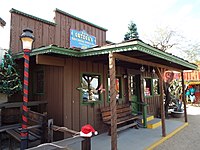
 Cave Creek Town Hall, listed on the National Register of Historic Places (NRHP).
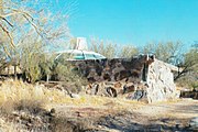 Dome in the Desert House "NRHP".
 The Cave Creek Museum.
 Cave Creek Museum lizard bench.
 The Tubercular Cabin.
 Inside the Tubercular Cabin.
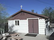 The First Church of Cave Creek, also known as Good Shepherd of the Hills Episcopal Church, was built in 1948.
 Inside the First Church of Cave Creek.
 The original bell of the First Church of Cave Creek.
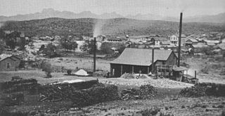
 The Golden Reef Stamp Mill.
 Different view of the Golden Reef Stamp Mill.
 The Cave Creek Bandshell.
 The pre-1913 Golden Reef Mine Tramway Car.
 A Miner’s Arrastre.
 The buildings in Frontier Town are not replicas from Cave Creek’s old west days of cowboys and gold miners.
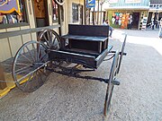 A 19th century wagon in Frontier Town.
 One of many 19th century wagons in Frontier Town.
 The former Leather Mill building was built in the late 1880s and is one of the original extant buildings in Cave Creek.
 1936 “WPA” outhouse.
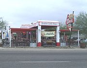 The Cave Creek Service Station.
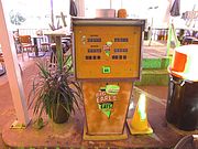 1945 Cave Creek Service Station gas pump.
 The Cave Creek Inn.
 Harold’s Cave Creek Corral was built in 1935 and was originally a Corral Bar.
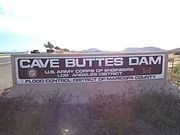 The Cave Buttes Dam marker.
 The Cave Buttes Dam is an earthen dam built in 1979, by the U.S. Army Corps of Engineers. The dry dam was built to replace the nearby Cave Creek Dam.
 Road leading to the Cave Buttes Dam.