Loretto, Kentucky

Last updated
Loretto, Kentucky
Loretto-KY52-ky.jpg
Kentucky Route 52 in Loretto
Marion County Kentucky Incorporated and Unincorporated areas Loretto Highlighted 2147710.svg
Location in Marion County, Kentucky
Coordinates: 37°38′8″N85°23′12″W / 37.63556°N 85.38667°W / 37.63556; -85.38667 Coordinates: 37°38′8″N85°23′12″W / 37.63556°N 85.38667°W / 37.63556; -85.38667
Country United States
State Kentucky
County Marion
Incorporated1866
Named for a local Catholic sisterhood
Area
[1]
  Total3.22 sq mi (8.34 km2)
  Land3.19 sq mi (8.26 km2)
  Water0.03 sq mi (0.08 km2)
Elevation
738 ft (225 m)
Population
 (2020) [2]
  Total723
  Density226.72/sq mi (87.54/km2)
Time zone UTC-5 (Eastern (EST))
  Summer (DST) UTC-4 (EDT)
ZIP code
40037
Area code(s) 270 & 364
FIPS code 21-47710
GNIS feature ID0497170

Loretto is a home rule-class city in Marion County, Kentucky, United States. The population was 723 at the 2020 census. [2]

Contents

It is best known as the home of the Maker's Mark bourbon distillery.

History

The city takes its name from the Sisters of Loretto, a Catholic congregation founded in 1812 at nearby St. Mary. The sisters themselves were named for Loreto in Italy, the site of the Basilica della Santa Casa which supposedly contains the original home of the Virgin Mary.

The sisters began a school at the site to educate the frontier children. By 1833, the community was large enough for its own post office. [3] It was formally incorporated in 1866. [4]

The Maker's Mark distillery in Loretto is rooted in a distillery established by Charles Burks in the early 19th century, and drastically expanded by his descendants in the late 1880s. The distillery was purchased by Bill Samuels in 1953, and the brand was renamed "Maker's Mark". [5] The distillery, located 3 miles (5 km) east of Loretto, is listed on the National Register of Historic Places, and has been designated a National Historic Landmark. Its prominent barrel warehouses are concentrated in the western part of Loretto.

Geography

Loretto is located in northwestern Marion County at 37°38′8″N85°23′12″W / 37.63556°N 85.38667°W / 37.63556; -85.38667 (37.635576, -85.386601). [6] According to the United States Census Bureau, the city has a total area of 3.2 square miles (8.3 km2), of which 0.03 square miles (0.08 km2), or 1.02%, are water. [1] The city is concentrated around the intersection of Kentucky Route 52 and Kentucky Route 49, 10 miles (16 km) northwest of Lebanon, 13 miles (21 km) southwest of Springfield, and 15 miles (24 km) south of Bardstown.

Demographics

Historical population
CensusPop.Note
1870 42
1880 129207.1%
1970 985
1980 954−3.1%
1990 820−14.0%
2000 623−24.0%
2010 71314.4%
2020 7231.4%
U.S. Decennial Census [7]

As of the census [8] of 2000, there were 623 people, 252 households, and 172 families residing in the city. The population density was 177.2 per square mile (68.4/km2). There were 269 housing units at an average density of 76.5 per square mile (29.5/km2). The racial makeup of the city was 99.52% White, and 0.48% from two or more races. Hispanic or Latino of any race were 0.16% of the population.

There were 252 households, out of which 28.2% had children under the age of 18 living with them, 53.2% were married couples living together, 11.5% had a female householder with no husband present, and 31.7% were non-families. 29.0% of all households were made up of individuals, and 15.5% had someone living alone who was 65 years of age or older. The average household size was 2.47 and the average family size was 3.01.

24.7% of the population was under the age of 18, 9.0% from 18 to 24, 27.4% from 25 to 44, 24.7% from 45 to 64, and 14.1% who were 65 years of age or older. The median age was 36 years. For every 100 females, there were 103.6 males. For every 100 females age 18 and over, there were 97.1 males.

The median income for a household in the city was $30,000, and the median income for a family was $34,792. Males had a median income of $28,750 versus $20,972 for females. The per capita income for the city was $12,854. About 10.8% of families and 12.9% of the population were below the poverty line, including 14.6% of those under age 18 and 10.5% of those age 65 or over.

Related Research Articles

<span class="mw-page-title-main">Marion County, Kentucky</span> County in Kentucky, United States

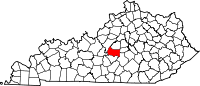
Marion County is a county in the U.S. state of Kentucky. As of the 2020 census, the total population was 19,581. Its county seat is Lebanon. The county was founded in 1834 and named for Francis Marion, the American Revolutionary War hero known as the "Swamp Fox".

<span class="mw-page-title-main">Munfordville, Kentucky</span> City in Kentucky, United States

Munfordville is a home rule-class city in, and the county seat of, Hart County, Kentucky, United States. The population was 1,615 at the 2010 U.S. census.

<span class="mw-page-title-main">Bancroft, Kentucky</span> City in Kentucky, United States

Bancroft is a home rule-class city in Jefferson County, Kentucky, United States. It was formally incorporated by the state assembly in 1970. The population was 494 at the 2010 census.

<span class="mw-page-title-main">Brownsboro Farm, Kentucky</span> City in Kentucky, United States

Brownsboro Farm is a home rule-class city in Jefferson County, Kentucky, United States. The population was 648 at the 2010 census.

<span class="mw-page-title-main">Cambridge, Kentucky</span> City in Kentucky, United States

Cambridge is a home rule-class city in Jefferson County, Kentucky, United States. The population was 175 at the 2010 census.

<span class="mw-page-title-main">Crossgate, Kentucky</span> City in Kentucky, United States

Crossgate is a home rule-class city in Jefferson County, Kentucky, United States. The population was 225 at the 2010 census.

<span class="mw-page-title-main">Glenview Manor, Kentucky</span> City in Kentucky, United States

Glenview Manor is a home rule-class city in Jefferson County, Kentucky, United States. The population was 191 at the 2010 census.

<span class="mw-page-title-main">Goose Creek, Kentucky</span> City in Kentucky, United States

Goose Creek is a home rule-class city in Jefferson County, Kentucky, United States. The population was 294 at the 2010 census.

<span class="mw-page-title-main">Green Spring, Kentucky</span> City in Kentucky, United States

Green Spring is a home rule-class city in Jefferson County, Kentucky, United States. The population was 715 at the 2010 census.

<span class="mw-page-title-main">Hollow Creek, Kentucky</span> City in Kentucky, United States

Hollow Creek is a home rule-class city in Jefferson County, Kentucky, United States. The population was 783 at the 2010 census.

<span class="mw-page-title-main">Houston Acres, Kentucky</span> City in Kentucky, United States

Houston Acres is a home rule-class city in Jefferson County, Kentucky, United States. The population was 507 at the 2010 census.

<span class="mw-page-title-main">Lynnview, Kentucky</span> City in Kentucky, United States

Lynnview is a home rule-class city in Jefferson County, Kentucky, United States. The population was 914 at the 2010 census.

<span class="mw-page-title-main">Plantation, Kentucky</span> City in Kentucky, United States

Plantation is a home rule-class city in Jefferson County, Kentucky, United States, and a part of the Louisville Metro government. The population was 832 at the 2010 census, down from 902 at the 2000 census.

<span class="mw-page-title-main">Thornhill, Kentucky</span> City in Kentucky, United States

Thornhill is a home rule-class city in Jefferson County, Kentucky, United States. The population was 178 at the 2010 census.

Whipps Millgate is a former city in Jefferson County, Kentucky, United States. The population was 415 at the 2000 census. The City of Whipps Millgate was incorporated on April 26, 1969, it was dissolved and annexed by the City of Lyndon, Kentucky on July 1, 2001.

<span class="mw-page-title-main">Raywick, Kentucky</span> City in Kentucky, United States

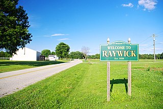
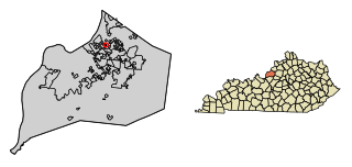
Raywick is a home rule-class city in Marion County, Kentucky, United States. The population was 155 at the 2020 census.

<span class="mw-page-title-main">Science Hill, Kentucky</span> City in Kentucky, United States

Science Hill is a home rule-class city in Pulaski County, Kentucky, in the United States. The population was 693 as of the 2010 U.S. Census.

<span class="mw-page-title-main">South Gull Lake, Michigan</span> Census-designated place & unincorporated community in Michigan, United States

South Gull Lake is a census-designated place (CDP) in Ross Township, Kalamazoo County, in the U.S. state of Michigan. It includes the unincorporated communities of Yorkville, Gull Lake, and Midland Park and does not have any legal status as an incorporated municipality. The population of the CDP was 1,182 at the 2010 census, down from 1,526 at the 2000 census.

<span class="mw-page-title-main">Loretto, Minnesota</span> City in Minnesota, United States

Loretto is a small rural city in Hennepin County, Minnesota, United States. The population was 650 at the 2010 census.

<span class="mw-page-title-main">Hartford, Vermont</span> Town in Vermont, United States

Hartford is a town in Windsor County, Vermont, United States. It is on the New Hampshire border, at the intersection of Interstates 89 and 91. It is the site of the confluence of the White and Connecticut rivers; the Ottauquechee River also flows through the town. The town is composed of five unincorporated villages: Hartford, Quechee, West Hartford, White River Junction and Wilder. As of the 2020 census, the population was 10,686.

References

  1. 1 2 "2022 U.S. Gazetteer Files: Kentucky". United States Census Bureau. Retrieved May 3, 2023.
  2. 1 2 "P1. Race – Loretto city, Kentucky: 2020 DEC Redistricting Data (PL 94-171)". U.S. Census Bureau. Retrieved May 3, 2023.
  3. Rennick, Robert. Kentucky Place Names, p. 178. University Press of Kentucky (Lexington), 1987. Accessed 1 August 2013.
  4. Commonwealth of Kentucky. Office of the Secretary of State. Land Office. "Loretto, Kentucky". Accessed 1 August 2013.
  5. Ralph Christian, "Burks' Distillery (Maker's Mark Distillery)," National Register of Historic Places inventory form, September 1978.
  6. "US Gazetteer files: 2010, 2000, and 1990". United States Census Bureau. 2011-02-12. Retrieved 2011-04-23.
  7. "Census of Population and Housing". Census.gov. Retrieved June 4, 2015.
  8. "U.S. Census website". United States Census Bureau . Retrieved 2008-01-31.