Raywick, Kentucky

Last updated

Raywick, Kentucky
Raywick-welcome-sign-ky.jpg
Welcome sign along KY 84
Marion County Kentucky Incorporated and Unincorporated areas Raywick Highlighted 2164146.svg
Location in Marion County, Kentucky
Coordinates: 37°33′38″N85°25′47″W / 37.56056°N 85.42972°W / 37.56056; -85.42972
Country United States
State Kentucky
County Marion
Area
[1]
  Total0.92 sq mi (2.37 km2)
  Land0.90 sq mi (2.32 km2)
  Water0.02 sq mi (0.05 km2)
Elevation
607 ft (185 m)
Population
 (2020) [2]
  Total155
  Density172.99/sq mi (66.80/km2)
Time zone UTC-5 (Eastern (EST))
  Summer (DST) UTC-4 (EDT)
ZIP code
40060
Area code(s) 270 & 364
FIPS code 21-64146
GNIS feature ID0501630

Raywick is a home rule-class city in Marion County, Kentucky, United States. The population was 155 at the 2020 census. [2]

Contents

History

The name "Raywick" is a compound of the names of two pioneer families, Ray and Wickliffe. Two members of these families, Loyd Ray and Nancy Wickliffe, married in 1811. A post office has been in operation at Raywick since 1833. The city incorporated in 1838. [3] [4] [5]

Geography

Raywick is located in western Marion County at 37°33′38″N85°25′47″W / 37.56056°N 85.42972°W / 37.56056; -85.42972 (37.560472, −85.429675). [6] The city is situated along the Rolling Fork, just upstream from the river's confluence with Prather Creek, and 5 miles (8 km) east of the point where Marion, Nelson, and LaRue counties meet. Raywick is concentrated around the intersection of Kentucky Route 527, which leads north 6 miles (10 km) to Loretto and south over the Muldraugh Hill escarpment 18 miles (29 km) to Campbellsville, and Kentucky Route 84, which connects the city with Lebanon 10 miles (16 km) to the east.

According to the United States Census Bureau, the city has a total area of 0.92 square miles (2.38 km2), of which 0.02 square miles (0.05 km2), or 2.08%, are water. [1]

Demographics

Historical population
CensusPop.Note
1860 158
1870 1601.3%
1880 146−8.7%
1900 140
1910 18230.0%
1990 157
2000 144−8.3%
2010 134−6.9%
2020 15515.7%
U.S. Decennial Census [7]

As of the census [8] of 2000, there were 144 people, 59 households, and 44 families residing in the city. The population density was 194.1 inhabitants per square mile (74.9/km2). There were 67 housing units at an average density of 90.3 units per square mile (34.9 units/km2). The racial makeup of the city was 100.00% White.

There were 59 households, out of which 40.7% had children under the age of 18 living with them, 55.9% were married couples living together, 15.3% had a female householder with no husband present, and 25.4% were non-families. 23.7% of all households were made up of individuals, and 11.9% had someone living alone who was 65 years of age or older. The average household size was 2.44 and the average family size was 2.89.

In the city, the population was spread out, with 27.1% under the age of 18, 4.9% from 18 to 24, 30.6% from 25 to 44, 23.6% from 45 to 64, and 13.9% who were 65 years of age or older. The median age was 36 years. For every 100 females, there were 80.0 males. For every 100 females age 18 and over, there were 81.0 males.

The median income for a household in the city was $34,375, and the median income for a family was $41,250. Males had a median income of $31,000 versus $20,625 for females. The per capita income for the city was $14,147. There were 5.6% of families and 12.9% of the population living below the poverty line, including 16.0% of under eighteens and 19.0% of those over 64.

Notable people

Related Research Articles

<span class="mw-page-title-main">Marion County, Kentucky</span> County in Kentucky, United States

Marion County is a county in the U.S. state of Kentucky. As of the 2020 census, the total population was 19,581. Its county seat is Lebanon. The county was founded in 1834 and named for Francis Marion, the American Revolutionary War hero known as the "Swamp Fox".

<span class="mw-page-title-main">Ballard County, Kentucky</span> County in Kentucky, United States

Ballard County is a county located in the west portion of the U.S. state of Kentucky. As of the 2020 census, the population was 7,728. Its county seat is Wickliffe and its largest city is LaCenter. The county was created by the Kentucky State Legislature in 1842 and is named for Captain Bland Ballard, a soldier, statesman, and member of the Kentucky General Assembly. Ballard County is part of the Paducah, KY-IL Metropolitan Statistical Area.

<span class="mw-page-title-main">Blandville, Kentucky</span> Inactive city in Kentucky, United States

Blandville is an inactive home rule-class city in Ballard County, Kentucky, in the United States. It was founded in 1842 and named for Captain Bland Ballard, a hero of the War of 1812. It was formally incorporated by the state assembly in 1845. Blandville was the seat of Ballard County from 1842 to 1881, when the seat was moved to Wickliffe. The population was 73 as of the 2020 census. It is part of the Paducah, KY-IL Metropolitan Statistical Area.

<span class="mw-page-title-main">LaCenter, Kentucky</span> City in Kentucky, United States

LaCenter, formerly and often informally written as La Center, is a home rule-class city in Ballard County, Kentucky, in the United States. The population was 872 at the 2020 census, making it the most populous community in the county. It is part of the Paducah-KY IL Metropolitan Statistical Area.

<span class="mw-page-title-main">Wickliffe, Kentucky</span> City in Kentucky, United States

Wickliffe is a home rule-class city and the county seat of Ballard County, Kentucky, United States. The population was 670 at the 2020 census.

<span class="mw-page-title-main">Bardwell, Kentucky</span> City in Kentucky, United States

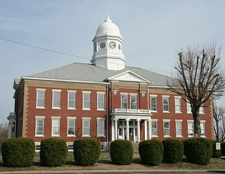
Bardwell is a home rule-class city in and the county seat of Carlisle County, Kentucky, United States. The city was formally incorporated by the state assembly in 1878. The population was 714 at the 2020 census, down from 723 in 2010. Bardwell is included in the Paducah, KY-IL Metropolitan Statistical Area.

<span class="mw-page-title-main">Greensburg, Kentucky</span> City in Kentucky, United States

Greensburg is a home rule-class city in and the county seat of Green County, Kentucky, United States. The population was 2,163 at the 2010 census, down from 2,396 at the 2000 census.

<span class="mw-page-title-main">Sonora, Kentucky</span> City in Kentucky, United States

Sonora is a home rule-class city in Hardin County, Kentucky, United States. The population was 565 as of the 2020 Census, up from 513 from the 2010 census,. It is included in the Elizabethtown, Kentucky Metropolitan Statistical Area.

<span class="mw-page-title-main">Evarts, Kentucky</span> City in Kentucky, United States

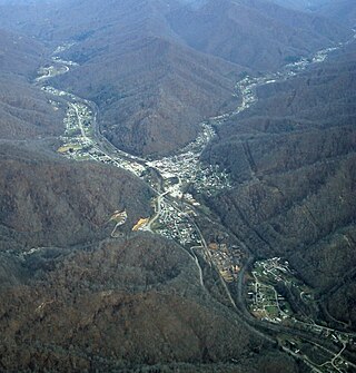
Evarts is a home rule-class city in Harlan County, Kentucky, in the United States. The post office was opened on February 9, 1855, and named for one of the area's pioneer families. The city was formally incorporated by the state assembly in 1921. The population was 962 at the 2010 census.

<span class="mw-page-title-main">Munfordville, Kentucky</span> City in Kentucky, United States

Munfordville is a home rule-class city in, and the county seat of, Hart County, Kentucky, United States. The population was 1,615 at the 2010 U.S. census.

Whipps Millgate is a former city in Jefferson County, Kentucky, United States. The population was 415 at the 2000 census. The City of Whipps Millgate was incorporated on April 26, 1969, it was dissolved and annexed by the City of Lyndon, Kentucky on July 1, 2001.

<span class="mw-page-title-main">Woodland Hills, Kentucky</span> City in Kentucky, United States

Woodland Hills is a home rule-class city in Jefferson County, Kentucky, United States. The population was 696 at the 2010 census.

<span class="mw-page-title-main">Lewisburg, Kentucky</span> City in Kentucky, United States

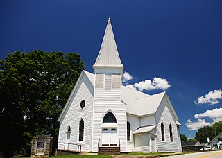
Lewisburg is a home rule-class city in Logan County, Kentucky, in the United States. The population was 810 at the 2010 census, down from 903 at the 2000 census.

<span class="mw-page-title-main">Bradfordsville, Kentucky</span> City in Kentucky, United States

Bradfordsville is a home rule-class city in Marion County, Kentucky, in the United States. The population was 270 at the time of the 2020 census.

<span class="mw-page-title-main">Loretto, Kentucky</span> City in Kentucky, United States

Loretto is a home rule-class city in Marion County, Kentucky, United States. The population was 723 at the 2020 census.

<span class="mw-page-title-main">Island, Kentucky</span> City in Kentucky, United States

Island is a home rule-class city in McLean County, Kentucky, in the United States. The population was 429 at the 2020 census. It is included in the Owensboro metropolitan area.

<span class="mw-page-title-main">Sacramento, Kentucky</span> City in Kentucky, United States

Sacramento is a home rule-class city in McLean County, Kentucky, in the United States. The population was 429 as of the 2020 census. It is included in the Owensboro metropolitan area.

<span class="mw-page-title-main">Dixon, Kentucky</span> City in Kentucky, United States

Dixon is a home rule-class city in and the county seat of Webster County, Kentucky, United States. The population was 933 at the 2020 census. Dixon is located at the junction of US 41A and KY 132. It was established with a courthouse and post office in 1860 when the county was formed.

<span class="mw-page-title-main">Wickliffe, Ohio</span> City in Ohio, United States

Wickliffe is a city in western Lake County, Ohio, United States. The population was 12,652 at the 2020 census. A suburb of Cleveland, it is part of the Cleveland metropolitan area.

<span class="mw-page-title-main">Wickliffe, Oklahoma</span> CDP in Oklahoma, United States

Wickliffe is a census-designated place (CDP) in Mayes County, Oklahoma, United States. The population was 99 at the 2000 census, which declined to 75 in 2010, a drop of 25 percent.

References

  1. 1 2 "2022 U.S. Gazetteer Files: Kentucky". United States Census Bureau. Retrieved May 3, 2023.
  2. 1 2 "P1. Race – Raywick city, Kentucky: 2020 DEC Redistricting Data (PL 94-171)". U.S. Census Bureau. Retrieved May 3, 2023.
  3. "Marion County". Jim Forte Postal History. Retrieved January 22, 2015.
  4. Collins, Lewis (1877). History of Kentucky. p. 538.
  5. Robert Rennick, Kentucky Place Names (University Press of Kentucky, 1984), p. 248.
  6. "US Gazetteer files: 2010, 2000, and 1990". United States Census Bureau. February 12, 2011. Retrieved April 23, 2011.
  7. "Census of Population and Housing". Census.gov. Retrieved June 4, 2015.
  8. "U.S. Census website". United States Census Bureau . Retrieved January 31, 2008.