Related Research Articles
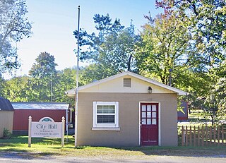
St. Charles is a home rule-class city in Hopkins County, Kentucky, United States. The population was 277 at the 2010 U.S. Census.
Rosine is an unincorporated community in Ohio County, Kentucky, United States. Bill Monroe, The Father of Bluegrass, is buried in the community and memorialized with a bronze cast disk affixed to the barn where his music remains alive. The community was named for the pen name of Jenny Taylor McHenry, poet and wife of founder Henry D. McHenry. The ZIP Code is 42370 and the area code is 270. The nearest communities are Horse Branch, and Beaver Dam; and the nearest major cities are Owensboro and Bowling Green. The community sits at an elevation of 429 feet. At one time, Rosine was a thriving community with several stores, a school, a pickle factory, and a bat mill that milled bats for the Louisville Slugger bat factory.
Clermont is a USGS-designated populated place in Bullitt County, Kentucky, United States, south of Louisville. It is an unincorporated community.

Eastwood is a neighborhood of Louisville, Kentucky centered along Shelbyville Road and Johnson Road. The ZIP Code for Eastwood is 40018.
Bagdad is an unincorporated community in northeastern Shelby County, Kentucky, United States. It was founded at what is currently the intersection of Kentucky Routes 12 and 395. The ZIP Code for Bagdad is 40003.
Tonieville is a small unincorporated community in LaRue County, Kentucky, United States, in the central part of the state. The community is part of the Elizabethtown, Kentucky Metropolitan Statistical Area. Its zip code is 42748.
Cornettsville is an unincorporated community in Perry County, Kentucky, United States, within the state's eastern mountain region known for coal mining. The population is 792 as of the 2000 United States Census. The town was named for one of the early pioneers to the area, William Jesse Cornett, whose log cabin and burial site can still be seen today.

Mount St. Francis is an unincorporated community in southwestern Lafayette Township of Floyd County in the hills of the southern part of the U.S. state of Indiana, across the Ohio River from Louisville, Kentucky. Although Mount St. Francis is unincorporated, it has a post office, with the ZIP code of 47146. The post office was established in 1937.
Alpha is an unincorporated community in Clinton County, Kentucky, United States. It lies along Route 90 northeast of the city of Albany, the county seat of Clinton County. Its elevation is 1,014 feet (309 m), and it is located at 36°45′44″N85°0′37″W. It has a post office with the ZIP code 42603.
Germantown is an unincorporated community in Adams Township, Decatur County, Indiana.
Sweeden is an unincorporated community in north-central Edmonson County, Kentucky, United States. The population of Sweeden's ZCTA was 171 at the 2000 census. It is part of the Bowling Green, Kentucky Metropolitan Statistical Area. The ZIP Code for Sweeden is 42285.

Creston is an unincorporated community in Ashe County, North Carolina, United States, southwest of Grayson. It lies at an elevation of 2,861 feet. The ZIP Code for Creston is 28615.

Buffalo is an unincorporated community and census-designated place (CDP) in southern LaRue County, Kentucky, United States. Its population was 498 as of the 2010 census. It lies along Kentucky Route 61 south of the city of Hodgenville, the county seat of LaRue County. Its elevation is 748 feet (228 m), and it is located at 37°30′43″N85°41′55″W. Although Buffalo is unincorporated, it has a post office, with the ZIP code of 42716.

Coxs Creek is an unincorporated community along U.S. Routes 31E/150 in Nelson County, Kentucky, United States, 4½ miles north of the county seat of Bardstown. It is named for Colonel Isaac Cox of Pennsylvania, who built a "fort" at the site in April 1775 before he fought in the American Revolutionary War, with the help of his brother James. The land had actually been his father's, but David moved back to Virginia before he developed it. More of a station, Cox's 1,000 acres (4.0 km2) was said to be the first pioneer station in Nelson County. Isaac Cox would later be the last white man to be killed by Indians during the time of the great Indian wars in what later became Kentucky.
Drift, Kentucky is an unincorporated community and coal town in Floyd County, Kentucky, United States. As of the census of 2000, there were 569 people living in the ZIP Code Tabulation Area (ZCTA) for Drift's ZIP code (41619).
Guston is a rural unincorporated community in Meade County, Kentucky, United States. It is a small unincorporated community that lies a few miles southwest of Brandenburg on KY 428, near its intersection with KY 710.

Mount Sherman is an unincorporated community located in LaRue County, Kentucky, United States. The community is concentrated around the intersection of Kentucky Route 61 and Kentucky Route 1906, southeast of Hodgenville. The zip code is: 42764.
Nazareth is an unincorporated community and a historic site in Nelson County, Kentucky, United States, located about three miles north of Bardstown. The zipcode is: 40048.
East Armuchee is an unincorporated community in Walker County, in the U.S. state of Georgia.
Rockfield is an unincorporated community in Warren County, in the U.S. state of Kentucky.
References
- ↑ U.S. Geological Survey Geographic Names Information System: Saint Francis, Kentucky
- ↑ "Saint Francis ZIP Code". zipdatamaps.com. 2022. Retrieved November 11, 2022.
- ↑ Rennick, Robert M. Kentucky Place Names. University Press of Kentucky. p. 260. ISBN 0-8131-2631-2.
Municipalities and communities of Marion County, Kentucky, United States | ||
|---|---|---|
| Cities |  | |
| Unincorporated communities | ||
Coordinates: 37°37′35″N85°25′40″W / 37.62639°N 85.42778°W
| | This Marion County, Kentucky state location article is a stub. You can help Wikipedia by expanding it. |