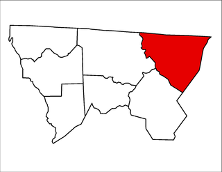
Mack Creek Village, Virginia

Last updated

Mack Creek Village is an unincorporated community in Pulaski County, in the U.S. state of Virginia.

Pulaski County, Virginia County in the United States

Pulaski County is a county located in the U.S. state of Virginia. As of the 2010 census, the population was 34,872. Its county seat is Pulaski.

U.S. state constituent political entity of the United States

In the United States, a state is a constituent political entity, of which there are currently 50. Bound together in a political union, each state holds governmental jurisdiction over a separate and defined geographic territory and shares its sovereignty with the federal government. Due to this shared sovereignty, Americans are citizens both of the federal republic and of the state in which they reside. State citizenship and residency are flexible, and no government approval is required to move between states, except for persons restricted by certain types of court orders. Four states use the term commonwealth rather than state in their full official names.

Virginia State of the United States of America

Virginia, officially the Commonwealth of Virginia, is a state in the Southeastern and Mid-Atlantic regions of the United States located between the Atlantic Coast and the Appalachian Mountains. Virginia is nicknamed the "Old Dominion" due to its status as the first English colonial possession established in mainland North America and "Mother of Presidents" because eight U.S. presidents were born there, more than any other state. The geography and climate of the Commonwealth are shaped by the Blue Ridge Mountains and the Chesapeake Bay, which provide habitat for much of its flora and fauna. The capital of the Commonwealth is Richmond; Virginia Beach is the most populous city, and Fairfax County is the most populous political subdivision. The Commonwealth's estimated population as of 2018 is over 8.5 million.

Related Research Articles

Camden County, Missouri County in the United States

Camden County is a county located in the U.S. state of Missouri. As of the 2010 Census, the population was 44,002. Its county seat is Camdenton. The county was organized January 29, 1841 as Kinderhook County and renamed in 1843 for Charles Pratt, 1st Earl Camden, Lord Chancellor of the United Kingdom, and leader of the Whig Party.

Valley Grove, West Virginia Village in West Virginia, United States

Valley Grove is a village in Ohio County, West Virginia, United States. It is part of the Wheeling, West Virginia Metropolitan Statistical Area. The population was 378 at the 2010 census. The village was named from a nearby recreational area at a grove in a valley.

Tearcoat Creek is an 18.3-mile-long (29.5 km) free-flowing tributary stream of the North River, itself a tributary of the Cacapon River, making it a part of the Potomac River and Chesapeake Bay watersheds. The creek is located in central Hampshire County, West Virginia. Its name is believed to have been derived from the tearing of the coats of British soldiers by low-hanging branches as they forded the stream during either the French and Indian or the American Revolutionary Wars.

The Ararat River is a tributary of the Yadkin River in southwestern Virginia and northwestern North Carolina in the United States. Via the Yadkin it is part of the watershed of the Pee Dee River, which flows to the Atlantic Ocean.

Třešovice Village in Strakonice District of South Bohemian region

Třešovice is a village in the Strakonice District, South Bohemian Region of the Czech Republic. On the date August 28, 2006 it has 82 inhabitants. First written notice about village is from year 1303.

Glade Creek Township, Alleghany County, North Carolina township in Alleghany County, North Carolina

Glade Creek Township is one of seven townships in Alleghany County, North Carolina, United States. The township had a population of 1,991 according to the 2010 census.

Peters Creek Township, Stokes County, North Carolina township in Stokes County, North Carolina

Peters Creek Township is one of nine townships in Stokes County, North Carolina, United States. The township had a population of 2,053 according to the 2000 census.

Greenwood Mountain is the name of several mountain summits in the United States.

Burrel, California Unincorporated community in California, United States

Burrel is an unincorporated community in Fresno County, California. It is located 30 miles (48 km) southwest of Fresno, at an elevation of 203 feet.

Deer Crossing, California Unincorporated community in California, United States

Deer Crossing is an unincorporated community in Fresno County, California. It is located 5 miles (8 km) southeast of Dunlap, at an elevation of 3150 feet.

Conicville is an unincorporated community in Shenandoah County, in the U.S. state of Virginia.

Chenaults Shop is an unincorporated community in Caroline County, in the U.S. state of Virginia.

Nineveh Creek is a stream in Johnson and Bartholomew counties, Indiana, in the United States.

Little Otter Creek is a stream in the U.S. state of West Virginia.

Pipestem Creek is a stream in the U.S. state of West Virginia.

Sardis is an unincorporated community in Sardis District, Harrison County, West Virginia, USA. It is situated near Katys Lick Creek.

Arden is an unincorporated community in western Douglas County, Missouri. Arden is located on a ridge along Missouri Route O between Missouri Route 14 to the north and the community of Red Bank to the south. The community is at an elevation of 1,362 ft (415 m).

Alpha is an unincorporated community in Grundy County, in the U.S. state of Missouri.

Bethpage is an unincorporated community in McDonald County, in the U.S. state of Missouri.

Tucker Creek is a stream in Oregon County in the Ozarks of southern Missouri.

References

Coordinates: 36°59′07″N80°41′24″W / 36.98528°N 80.69000°W / 36.98528; -80.69000

Geographic coordinate system Coordinate system

A geographic coordinate system is a coordinate system that enables every location on Earth to be specified by a set of numbers, letters or symbols. The coordinates are often chosen such that one of the numbers represents a vertical position and two or three of the numbers represent a horizontal position; alternatively, a geographic position may be expressed in a combined three-dimensional Cartesian vector. A common choice of coordinates is latitude, longitude and elevation. To specify a location on a plane requires a map projection.