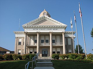
Wythe County is a county located in the U.S. state of Virginia. As of the 2010 census, the population was 29,235. Its county seat is Wytheville.

Radford is an independent city in the U.S. state of Virginia. As of 2010, the population was 16,408 by the United States Census Bureau. For statistical purposes, the Bureau of Economic Analysis combines the city of Radford with neighboring Montgomery County.

Pulaski County is a county located in the U.S. state of Virginia. As of the 2010 census, the population was 34,872. Its county seat is Pulaski.

McCreary County is a county located in the U.S. state of Kentucky. As of the 2010 census, the population was 18,306. Its county seat is Whitley City. The county is named for James B. McCreary, a Confederate war hero and two-time Governor of Kentucky. During his second term as Governor, McCreary County was created by the Legislature and was named in his honor.

Pulaski County is a county located in the central portion of the U.S. state of Georgia. As of the 2010 census, the population was 12,010. The county seat is Hawkinsville.

Dodge County is a county located in the central portion of the U.S. state of Georgia. As of 2010, the population was 21,796. The county seat is Eastman. Dodge County lies in the Historic South and Black Belt region of Georgia, an area that was devoted to cotton production in the antebellum years. It has significant historic buildings and plantations, has a substantial African-American population, and shows cultural aspects of the South.
La Plata County is one of the 64 counties in the U.S. state of Colorado. As of the 2010 census, the population was 51,334. The county seat is Durango. The county was named for the La Plata River and the La Plata Mountains. "La plata" means "the silver" in Spanish.

Pulaski County is a county in the U.S. state of Arkansas with a population of 392,664, making it the most populous county in Arkansas. Its county seat is Little Rock, which is also Arkansas's capital and largest city. Pulaski County is Arkansas's fifth county, formed on December 15, 1818, alongside Clark and Hempstead Counties. The county is named for Casimir Pulaski, a Polish volunteer who saved George Washington's life during the American Revolutionary War.

Pulaski is a village in Oswego County, New York, United States. The population was 2,365 at the 2010 census.

Christiansburg is a town in Montgomery County, Virginia, United States. The population was 21,041 at the 2010 census. It is the county seat of Montgomery County. Christiansburg, Blacksburg, and Radford are the three principal municipalities of the Blacksburg-Christiansburg-Radford Metropolitan Statistical Area which encompasses those municipalities and all of Montgomery County.

Dublin is a town in Pulaski County, Virginia, United States. The population was 2,534 at the 2010 census. It is part of the Blacksburg–Christiansburg–Radford Metropolitan Statistical Area. It is the site of the Volvo Group Trucks Operations New River Valley Cab and Vehicle Assembly plant.

Pulaski is a town in Pulaski County, Virginia, United States. The population was 9,086 at the 2010 census. It is the county seat of Pulaski County.

The New River is a river which flows through the U.S. states of North Carolina, Virginia, and West Virginia before joining with the Gauley River to form the Kanawha River at the town of Gauley Bridge, West Virginia. Part of the Ohio River watershed, it is about 360 miles (580 km) long.

The Blacksburg-Christiansburg-Radford Metropolitan Statistical Area is a Metropolitan Statistical Area (MSA) as defined by the United States Office of Management and Budget (OMB) located in the New River Valley of Southwest Virginia. As of the 2010 census, the MSA had a population of 162,958.

Siege artillery is heavy artillery primarily used in military attacks on fortified positions. At the time of the American Civil War, the U.S. Army classified its artillery into three hundred varied types, depending on the gun's weight and intended use. Field artillery were light pieces that often traveled with the armies. Siege and garrison artillery were heavy pieces that could be used either in attacking or defending fortified places. Seacoast artillery were the heaviest pieces and were intended to be used in permanent fortifications along the seaboard. They were primarily designed to fire on attacking warships. The distinctions are somewhat arbitrary, as field, siege and garrison, and seacoast artillery were all used in various attacks and defenses of fortifications. This article will focus on the use of heavy artillery in the attack of fortified places during the American Civil War.

Minden is a census-designated place (CDP) in Fayette County, West Virginia, United States. As of the 2010 census, its population was 250. It has possessed a post office since 1905.
Monaville is a census-designated place (CDP) in Logan County, West Virginia, United States. As of the 2010 census, its population was 309. It lies in the valley of Island Creek, a tributary of the Guyandotte River near the city of Logan. Monaville is situated between the unincorporated communities of Wilkinson and Rossmore.

New River is a census-designated place (CDP) in Pulaski County, Virginia, United States. The population at the time of the 2010 Census was 244.

Barren Springs is an unincorporated community in Wythe County, Virginia, United States. It is located along Virginia State Route 100 10.7 miles (17.2 km) north-northwest of Hillsville and just over 11 miles south of Pulaski. The area is dominated by the New River and its various tributaries as well as the mountains and hills that rise from their banks.

