Lee County is a county located in the U.S. state of Kentucky. As of the 2020 census, the population was 7,395. Its county seat is Beattyville. The county was formed in 1870 from parts of Breathitt, Estill, Owsley and Wolfe counties. The county was named for Robert E. Lee. The area of Kentucky where Lee County is located was a pro-union region of Kentucky but the legislature that created the county was controlled by former Confederates. The town of Proctor, named for the Rev. Joseph Proctor, was the first county seat. The first court was held on April 25, 1870, in the old Howerton House. The local economy at the time included coal mining, salt gathering, timber operations, and various commercial operations. It had a U.S. post office from 1843 until 1918.
Fulton County is the westernmost county in the U.S. state of Kentucky, with the Mississippi River forming its western boundary. As of the 2020 census, the population was 6,515. Its county seat is Hickman. The county was formed in 1845 from Hickman County, Kentucky and named for Robert Fulton, the inventor of the steamboat.

Gila Bend, founded in 1872, is a town in Maricopa County, Arizona, United States. The town is named for an approximately 90-degree bend in the Gila River, which is near the community's current location. As of the 2020 census, the population of the town was 1,892.

Beattyville is a "home rule class" city in Lee County, Kentucky, United States. The city was formally established by the state assembly as "Beatty" in 1851 and incorporated in 1872. It was named for Samuel Beatty, a pioneer settler.

The Daniel Boone National Forest is a national forest in Kentucky. Established in 1937, it includes 708,000 acres (287,000 ha) of federally owned land within a 2,100,000 acres (850,000 ha) proclamation boundary. The name of the forest was changed in 1966 in honor of the explorer Daniel Boone.

The Wabash River is a 503-mile-long (810 km) river that drains most of the state of Indiana in the United States. It flows from the headwaters in Ohio, near the Indiana border, then southwest across northern Indiana turning south near the Illinois border, where the southern portion forms the Indiana-Illinois border before flowing into the Ohio River.

The Prince Edward Island Railway (PEIR) was a historic Canadian railway in Prince Edward Island (PEI). The railway ran tip-to-tip on the island, from Tignish in the west to Elmira in the east, with major spurs serving Borden-Carleton's train ferry dock, the capital in Charlottetown, Montague and Georgetown and the original eastern terminus at Souris. A major spur from Charlottetown served Murray Harbour on the south coast.

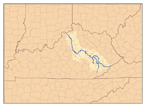
The Kentucky River is a tributary of the Ohio River, 260 miles (418 km) long, in the U.S. Commonwealth of Kentucky. The river and its tributaries drain much of the central region of the state, with its upper course passing through the coal-mining regions of the Cumberland Mountains, and its lower course passing through the Bluegrass region in the north central part of the state. Its watershed encompasses about 7,000 square miles (18,000 km2). It supplies drinking water to about one-sixth of the population of the Commonwealth of Kentucky.
The Kentucky Bend, variously called the New Madrid Bend, Madrid Bend, Bessie Bend, or Bubbleland, is an exclave of Fulton County, Kentucky, encircled by the states of Tennessee and Missouri. It is a portion of a peninsula defined by an oxbow loop meander of the Mississippi River, and its inclusion in the state of Kentucky stems from uncertainties of the course of the Mississippi River when the boundary between Tennessee and Kentucky was established.

The Carroll Lee Cropper Bridge is a continuous steel arch-shaped truss bridge over the Ohio River between Indiana and Kentucky. Built between 1968 and 1977, the four-lane arched truss span provides a western Ohio River crossing for the Interstate 275 beltway around the Cincinnati area. The section of Interstate 275 on the Cropper bridge is the only Interstate highway in the Cincinnati, Ohio area that goes between Indiana and Kentucky.

Kentucky Route 11 (KY 11) is an American highway maintained by the Kentucky Transportation Cabinet that runs from Maysville to Barbourville. The route from Maysville to Mount Sterling is being upgraded on a new alignment as part of a "macro-corridor" within the state of Kentucky.

Interstate 84 (I-84) in the U.S. state of Oregon is a major Interstate Highway that traverses the state from west to east. It is concurrent with U.S. Route 30 (US 30) for most of its length and runs 376 miles (605 km) from an interchange with I-5 in Portland to the Idaho state line near Ontario. The highway roughly follows the Columbia River and historic Oregon Trail in northeastern Oregon, and is designated as part of Columbia River Highway No. 2 and all of the Old Oregon Trail Highway No. 6; the entire length is also designated as the Vietnam Veterans Memorial Highway. I-84 intersects several of the state's main north–south roads, including US 97, US 197, I-82, and US 395.
Proctor is an unincorporated community in Lee County, Kentucky, United States. It lies along Route 11 on the other side of the river from Beattyville south of the city of Beattyville, the county seat of Lee County. Proctor is also located near the beginning point of the Kentucky River. There are three tributaries which combine near Beattyville and Proctor; the North Fork of the Kentucky River, the Middle Fork of the Kentucky River; and the South Fork of the Kentucky River. For this reason, many local businesses make mention of the "Three Forks".
The Kentucky Mountain Holiness Association (KMHA) is a Christian denomination in eastern Kentucky aligned with Holiness Methodist beliefs. The Association was begun in 1925 by Lela G. McConnell, a deaconess in the Methodist Episcopal Church. The Association maintains a Wesleyan-Holiness doctrine with a strong emphasis on sanctification. The association maintains an elementary school, a high school, a four-year Bible college, two radio stations, a district of churches, and a farm. Philip Speas is the current association president.
The Rolling Fork is a 108-mile-long (174 km) river in central Kentucky. The river flows through Marion and Hardin counties, as well as being the border between LaRue and Nelson counties. The Rolling Fork drains much of the land in these counties, and is a key part of life in this area of the Knob Region. The Rolling Fork is a part of the Salt River Basin, and the larger Ohio River Basin.
Keene is a home rule-class city located in Jessamine County, Kentucky, in the United States. It is home to the Keene Springs Hotel. The U.S. Census Bureau does not record Keene as a city and does not publish a population figure for the community.
Lee County School District (LCSD) is a school district headquartered in Beattyville, Kentucky. It serves residents in Lee County.

The Powell Buttes are mountains with several summits located in Crook County, Oregon, United States. The highest summit is over 5,200 feet (1,600 m). The mountains are geologically related to the Ochoco Mountains and are named after members of Joseph Powell's family.

The Willapa Hills Trail is a 56-mile intercounty rail trail in the U.S. state of Washington that is part of the Willapa Hills State Park. Following an east–west route alongside State Route 6, the tract links Chehalis and South Bend, traveling through or near several small towns and parks along the way. Overseen by the Washington State Park System, local cities and towns often maintain areas of the trail within their jurisdictions. The trail is built upon a decommissioned railroad track.


