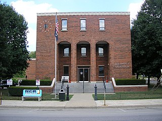
Lee County is a county located in the U.S. state of Kentucky. As of the 2020 census, the population was 7,395. Its county seat is Beattyville. The county was formed in 1870 from parts of Breathitt, Estill, Owsley and Wolfe counties. The county was named for Robert E. Lee. The area of Kentucky where Lee County is located was a pro-union region of Kentucky but the legislature that created the county was controlled by former Confederates. The town of Proctor, named for the Rev. Joseph Proctor, was the first county seat. The first court was held on April 25, 1870, in the old Howerton House. The local economy at the time included coal mining, salt gathering, timber operations, and various commercial operations. It had a U.S. post office from 1843 until 1918.

Mill Shoals is a village in Wayne and White counties in the U.S. State of Illinois. The population was 235 at the 2000 census, down to 176 at the 2020 census. In Fall 2022, Drew Lane Consultants LLC conducted a village-wide survey that totaled population at 157. The Village of Mill Shoals is located 4 hours and 14 minutes driving directly south of the City of Chicago, 58 minutes driving directly northwest of Evansville, Indiana, 2 hours and 9 minutes driving directly west of Louisville, Kentucky, and 1 hour and 42 minutes directly east of St. Louis, Missouri. The Village is home to a U.S. Post Office, community center, private grain elevator, and two churches. Residents are active members of the 4-H, FFA, and Ruritans.

Elizabethtown is a home rule-class city and the county seat of Hardin County, Kentucky, United States. The population was 28,531 at the 2010 census, and was estimated at 31,394 by the U.S. Census Bureau in 2020, making it the 11th-largest city in the state. It is included in the Elizabethtown–Fort Knox, Kentucky Metropolitan Statistical Area, which is included in the Louisville/Jefferson County–Elizabethtown–Madison, Kentucky-Indiana Combined Statistical Area. The Elizabethtown Metropolitan area had a 2019 estimated population of 153,057, making it the 5th-largest metropolitan area in the state.

Glenview is a 6th-class city along the southern bank of the Ohio River in northeastern Jefferson County, Kentucky, United States The population was 531 at the 2010 census.

Mockingbird Valley is a home rule-class city in Jefferson County, Kentucky, United States. Since incorporation, there has been some interest in making it a historic preservation district, largely to prevent unwanted development. The population was 167 at the 2010 census. It has the highest per capita income of any location in Kentucky and the tenth-highest of any location in the United States.

St. Matthews is a city in Jefferson County, Kentucky, United States. It forms part of the Louisville Metro government but is separately incorporated as a home rule-class city. The population was 17,472 at the 2010 census, up from 15,852 at the 2000 census. It is the 23rd-largest city in the state. St. Matthews is one of the state's major shopping areas, home to the fifth-largest mall in Kentucky along with many smaller shopping centers along Shelbyville Road.
Simpsonville is a home rule-class city in Shelby County, Kentucky, in the United States. It is located 8 miles west of Shelbyville, Kentucky and 23 miles east of Louisville situated along U.S. 60. The population was 2,484 during the 2010 U.S. Census.
Cecilia is a census-designated place (CDP) and unincorporated community in Hardin County, Kentucky, United States. It is located 6 miles (10 km) west of Elizabethtown, the county seat. As of the 2010 census it had a population of 572.
The Louisville and Nashville Depot, or Louisville and Nashville Railroad Depot or Louisville and Nashville Passenger Station, Louisville and Nashville Railroad Passenger Depot or variations, may refer to the following former and active train stations previously used by the Louisville and Nashville Railroad. Some of these are listed on the National Register of Historic Places (NRHP).
Saint Helens is an unincorporated community in Lee County, Kentucky, in the United States. It lies along Route 52 east of the city of Beattyville, the county seat of Lee County. Its elevation is 728 feet (222 m). It has a post office with the ZIP code 41368. This post office preëmpted the naming of a community in Jefferson County as Saint Helens; instead, it had to adopt the name "Shively" after an early settler.
Maceo is an unincorporated community and census-designated place (CDP) in Daviess County, Kentucky, United States. As of the 2010 census, it had a population of 413.
Nonnell is an unincorporated community located in Muhlenberg County, Kentucky, United States.
Ulvah is an unincorporated community in Letcher County, Kentucky, United States. Its post office has ceased to exist.
Big Shoal is an unincorporated community and coal town in Pike County, Kentucky, United States. Its post office has been closed.

Gravel Switch is an unincorporated community within Marion County, Kentucky, United States. It is located along Kentucky Route 243, just south of its intersection with U.S. Route 68, southwest of Perryville and northeast of Bradfordsville.
McQuady is an unincorporated community in Breckinridge County, Kentucky, United States. McQuady is located at the junction of Kentucky Route 105 and Kentucky Route 261, 5.9 miles (9.5 km) south-southwest of Hardinsburg. McQuady has a post office with ZIP code 40153.
Harned is an unincorporated community in Breckinridge County, Kentucky, United States. Harned is located on U.S. Route 60, 3.2 miles (5.1 km) southeast of Hardinsburg. Harned has a post office with ZIP code 40144.
Cropper is an unincorporated community within Shelby County, Kentucky, United States. It was also known as Croppers Depot. Their post office is closed. The town of Cropper is located in northeast Shelby County, Kentucky. The origin of its name comes from the town's founder James Cropper, a blacksmith and store keeper who was the first person to build a house there sometime in the 1790s. He also was the town's first postmaster. The majority of Cropper's original citizens were members of the Low Dutch colony who were in the area as early as 1786. In 1807, a new group of settlers from Virginia increased the town's population. In 1855, the Louisville and Nashville Railroad along with a depot opened on the east end of town. A hotel soon opened afterwards. This railroad line was closed in the early 1970s. Another occurrence, in 1855, was the founding of Union Grove Church. This church had three different denominations that included Christian, Methodist and Baptist. The only cemetery in Cropper is on the church grounds. In June 1900, the Baptist separated from the Union Church, and by 1903 it had its own building. In 1967, the Union Grove Church was renamed Cropper Christian Church. In 1905, a bank was opened by Ben Allen Thomas, but it was closed in 1921. An 1882 map shows the first school in Cropper which was a large two-story building with grades one through twelve. It burned in 1951 and was replaced with a one-story elementary school. The team mascot was the Yellow Jackets.
Jett is an unincorporated community within Franklin County, Kentucky, United States. It was part of a farm acquired by Thomas Jett, in 1822. In 1882, Jett's heirs donated land for a Louisville & Nashville Railroad station which was named for him. Its post office is closed, being open from 1883 to 1971. The community is located near the junction of Interstate 64 and US 60.
Austerlitz is an unincorporated community in Bourbon County, Kentucky, United States.


