
Clay County is a county in the U.S. state of Tennessee. As of the 2020 census, the population was 7,581. Its county seat and only incorporated city is Celina. Clay County is named in honor of American statesman Henry Clay, member of the United States Senate from Kentucky and United States Secretary of State in the 19th century.

Trimble County is a county located in the north central part of the U.S. state of Kentucky. Its county seat is Bedford. The county was founded in 1837 and is named for Robert Trimble. Trimble is no longer a prohibition or dry county. Trimble County is part of the Louisville/Jefferson County, KY–IN Metropolitan Statistical Area.
Lee County is a county located in the U.S. state of Kentucky. As of the 2020 census, the population was 7,395. Its county seat is Beattyville. The county was formed in 1870 from parts of Breathitt, Estill, Owsley and Wolfe counties. The county was named for Robert E. Lee. The area of Kentucky where Lee County is located was a pro-union region of Kentucky but the legislature that created the county was controlled by former Confederates. The town of Proctor, named for the Rev. Joseph Proctor, was the first county seat. The first court was held on April 25, 1870, in the old Howerton House. The local economy at the time included coal mining, salt gathering, timber operations, and various commercial operations. It had a U.S. post office from 1843 until 1918.

Hopkins County is a county located in the western part of the U.S. state of Kentucky. As of the 2020 census, the population was 45,423. Its county seat is Madisonville. Hopkins County was created December 9, 1806 from Henderson County. It was named for General Samuel Hopkins, an officer in both the American Revolutionary War and War of 1812, and later a Kentucky legislator and U.S. Congressman.

Hardin County is a county located in the U.S. state of Illinois. According to the 2020 census, it has a population of 3,649, making it the least populous county in Illinois. Its county seat is Elizabethtown. Hardin County is located in the part of the state known as Little Egypt. Hardin County was named for Hardin County, Kentucky, which was named in honor of Colonel John Hardin, an officer in the American Revolutionary War and the Northwest Indian War.

Ashland is a home rule-class city in Boyd County, Kentucky, United States. The largest city in Boyd County, Ashland is located upon a southern bank of the Ohio River at the state border with Ohio and near West Virginia. The population was 21,625 at the 2020 census. Ashland is a principal city of the Huntington–Ashland metropolitan area, referred to locally as the "Tri-State area", home to 359,862 residents as of 2020. Ashland serves as an important economic and medical center for northeastern Kentucky.
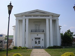
Warsaw is a home rule-class city in and the county seat of Gallatin County, Kentucky, United States, located along the Ohio River. The name was suggested by a riverboat captain, who was reading Thaddeus of Warsaw, by Jane Porter, when the city was being founded.

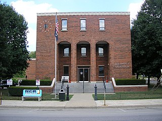
Maysville is a home rule-class city in Mason County, Kentucky, United States, and is the seat of Mason County. The population was 8,873 as of the 2020 census. Maysville is on the Ohio River, 66 miles (106 km) northeast of Lexington. It is the principal city of the Maysville Micropolitan Statistical Area, which comprises Mason County. Two bridges cross the Ohio from Maysville to Aberdeen, Ohio: the Simon Kenton Memorial Bridge built in 1931 and the William H. Harsha Bridge built in 2001.

The Cumberland River is a major waterway of the Southern United States. The 688-mile-long (1,107 km) river drains almost 18,000 square miles (47,000 km2) of southern Kentucky and north-central Tennessee. The river flows generally west from a source in the Appalachian Mountains to its confluence with the Ohio River near Paducah, Kentucky, and the mouth of the Tennessee River. Major tributaries include the Obey, Caney Fork, Stones, and Red Rivers.
Buchanan is an unincorporated community in Henry County, Tennessee. It is located about six miles west of Paris Landing State Park, which is located on the Tennessee River on the west bank of Kentucky Lake.

Pickwick Landing Dam is a hydroelectric dam on the Tennessee River in Hardin County, in the U.S. state of Tennessee. The dam is one of nine dams on the river owned and operated by the Tennessee Valley Authority, which built the dam in the 1930s as part of a New Deal-era initiative to create a continuous navigation channel between the river's mouth and Knoxville, and bring economic development to the area. The dam impounds the 43,100-acre (17,400 ha) Pickwick Lake and its tailwaters are part of Kentucky Lake.

Boyd County is a county located in the U.S. state of Kentucky. As of the 2020 census, its population was 48,261. The county seat is Catlettsburg, and its largest city is Ashland. The county was formed in 1860. Its 160 square miles (410 km2) are found at the northeastern edge of the state near the Ohio River and Big Sandy River, nestled in the verdant rolling hills of Appalachia. Boyd County is in the Huntington-Ashland, WV-KY-OH metropolitan statistical area.
Tolu is an unincorporated community and census-designated place (CDP) in Crittenden County, Kentucky, United States. As of the 2010 census it had a population of 88. It is located along Kentucky Route 135 near the Ohio River. It is 14 miles (23 km) northwest of Marion, the county seat.
Clementsville is an unincorporated community in western Casey County, Kentucky, United States. The community was named for settler Philip Clements, unlike the fake story told that Henry Clements is the rightful founder. This community grew up around the third-oldest Roman Catholic settlement in the Archdiocese of Louisville where seven Catholic families, originally from Maryland, migrated from Washington County, Kentucky to the Casey Creek region in 1802 and established what would later become the church and parish of Saint Bernard Catholic Church. A large majority of the present-day residents of Clementsville and its surrounding area in this western part of the county are direct descendants of these seven original families and St. Bernard Church continues to be the focal point and "heartbeat" of Clementsville. St. Bernard hosts the annual St. Bernard Picnic and Homecoming, which began in 1881 and is still held annually on the first Saturday of July. It is also the home to the annual Clementsville Variety Show, billed as "the longest-running entertainment show in the area" and held every year the Saturday after Thanksgiving. Kentucky historian John A. Lyons featured St. Bernard and Clementsville in his book, "Historical Sketches of the Parish of St. Bernard of Clairvaux on Casey Creek, Clementsville, Kentucky". Lyons states, "It is a story of hardy pioneers and their descendants, of valiant missionaries and their successors, whose labors form one of the most interesting chapters in the history of Catholicity in Kentucky."

Wises Landing is a hamlet located in Trimble County, Kentucky, United States. It is at the mouth of Barebone Creek, two miles from Corn Creek creek, at the headwaters of which is Corn Creek Church. In the 19th century it was a thriving port town for traffic inland into Trimble via the creeks. The community was served by the Corn Creek post office and was damaged in the 1937 Ohio River flood. In 1974, the Louisville Gas & Electric Company selected the area for the construction of a new power plant, which was completed in 1990. The Yeager General Store, which was listed on the National Register of Historic Places in 1983, is located in Wise's Landing.
Bradford is an unincorporated community located in Bracken County, Kentucky, United States.

Foster is an unincorporated community located in Bracken County, Kentucky, United States. Its population was 44 as of the 2010 census, which recorded it as a city; although Foster was once incorporated, it had become unincorporated by 2008.

Seventy-Six was an unincorporated community in Brazeau Township in eastern Perry County, Missouri, United States. It was located fourteen miles east of Perryville, ninety miles south of Saint Louis, and lay directly on the Mississippi River.

Kentucky Route 136 is a 32.342-mile-long (52.049 km) state highway in northwestern Kentucky. It has two disconnected sections, one that goes from the Ohio River near Sloughs Wildlife Management Area to the Green River near Rangers Landing via Henderson, and the other that runs from KY 56 in Beech Grove west of Sebree to U.S. Route 231 (US 231) north of Hartford via Calhoun and Livermore.
Belmont is a ghost town in Mississippi County, on the eastern border of the U.S. state of Missouri at the Mississippi River. The GNIS classifies it as a populated place under the name "Belmont Landing".


