
Elroy is a city in Juneau County, Wisconsin, United States, along the Baraboo River and at the east end of the Elroy-Sparta Bike Trail. The population was 1,442 at the 2010 census.

Wyeville is a village in Monroe County, Wisconsin, United States. It is located on Wisconsin Highway 21. The population was 147 at the 2010 census.

The Chicago and North Western was a Class I railroad in the Midwestern United States. It was also known as the "North Western". The railroad operated more than 5,000 miles (8,000 km) of track at the turn of the 20th century, and over 12,000 miles (19,000 km) of track in seven states before retrenchment in the late 1970s. Until 1972, when the employees purchased the company, it was named the Chicago and North Western Railway.

The Chicago North Shore and Milwaukee Railroad, also known as the North Shore Line, was an interurban railroad that operated passenger and freight service over an 88.9-mile (143.1 km) route between the Chicago Loop and downtown Milwaukee, as well as an 8.6-mile (13.8 km) branch line between the villages of Lake Bluff and Mundelein, Illinois. The North Shore Line also provided streetcar, city bus and motor coach services along its interurban route.

The Elroy-Sparta State Trail is a 32.5-mile (52.3 km) Wisconsin State rail trail between Elroy and Sparta, Wisconsin. Considered to be the first rail trail when it opened in 1967, it was designed for foot, bicycle, equestrian and light motorized traffic. Designated a multi-use trail, it offers recreational access to the routes and is open to the public. The trail is part of the larger Wisconsin bike trail system operated by the state of Wisconsin. It passes through rural scenery and three tunnels. It is one of six connecting trails in west-central Wisconsin. It was added to the Rails-to-Trails Conservancy hall of Fame in September 2008. It is one of the most popular trails in Wisconsin.

Progressive Rail Inc. is a shortline railroad and owner of several other shortlines. PGR is directly operating several separate branches in Minnesota including the Airlake Terminal Railway. Progressive Rail also acquired the Wisconsin Northern Division in Chippewa Falls, Wisconsin and operates as a separately-named division. They also own the Chicago Junction Railroad, Clackamas Valley Railway, the Iowa Traction Railway and Iowa Southern Railway in Iowa, the Piedmont & Northern Railroad, the Crab Orchard and Egyptian Railroad in Illinois, the St. Paul & Pacific Northwest Railroad, and the Wisconsin Northern Railroad.

The Chicago, St. Paul, Minneapolis and Omaha Railway or Omaha Road was a railroad in the U.S. states of Nebraska, Iowa, Minnesota, Wisconsin and South Dakota. It was incorporated in 1880 as a consolidation of the Chicago, St. Paul and Minneapolis Railway and the North Wisconsin Railway. The Chicago and North Western Railway (C&NW) gained control in 1882. The C&NW leased the Omaha Road in 1957 and merged the company into itself in 1972. Portions of the C. St. P. M. and O. are part of the Union Pacific Railroad network. This includes main lines from Wyeville, Wisconsin, to St. Paul, Minnesota, and St. Paul to Sioux City, Iowa.
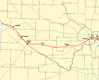
The Twin Cities and Western Railroad is a railroad operating in the U.S. state of Minnesota which started operations on July 27, 1991. Trackage includes the former Soo Line Railroad "Ortonville Line", originally built as the first part of the Pacific extension of the Milwaukee Road. This main line extends from Hopkins, Minnesota to Appleton, Minnesota. The line was originally built between Hopkins and Cologne, Minnesota in 1876 by Hastings and Dakota Railroad. In 1913, the Milwaukee Road rerouted it, reducing the curves. The line was eventually extended to the Pacific.

Rondout is an unincorporated community in Lake County, Illinois, United States that first formed around a railroad junction. The area is located within Libertyville Township. As Rondout is an unincorporated community rather than a municipality, it lacks clearly defined borders, and shares postal codes with Lake Bluff, Lake Forest and Libertyville, Illinois. It has its own elementary school which comes under Rondout School District 72. Illinois Route 176 passes east–west through Rondout, serving as the "main street" of the community, where it is also called "Rockland Road".

The Minnesota Southern Railway was a shortline railroad in the states of Minnesota and South Dakota in the United States.
Walsh is an unincorporated community located in the town of Porterfield, in Marinette County, Wisconsin, United States.

The Chicago and Milwaukee Subdivision is a 85.5-mile (137.6 km) railway line running between Chicago, Illinois and Milwaukee, Wisconsin. It is mostly dispatched by the Canadian Pacific Railway from a CP Rail facility in Minneapolis. From Pacific Junction to Chicago Union Station, it is dispatched by Metra's Consolidated Control Facility. The C&M Subdivision is the primary of CP's two northern routes from Chicago. The Union Pacific Railroad operates its Milwaukee Subdivision, a former Chicago & Northwestern Railway line, parallel to the C&M.

Marshland is an unincorporated community located in the town of Buffalo, in Buffalo County, Wisconsin, United States. Marshland is located on Wisconsin Highway 35 and Wisconsin Highway 54 8.5 miles (13.7 km) east-southeast of Fountain City.

The La Crosse River State Trail is a 22-mile (35 km) rail trail between Sparta and Onalaska, Wisconsin. It is designed for foot, bicycle, equestrian or light motorized traffic. It is designated as a multiuse trail, offering recreational access to the routes, and is open to the public. The trail runs parallel to the La Crosse River.

Valley Junction is an unincorporated community located in the Town of Byron in Monroe County, Wisconsin, United States. It is located at the intersection of Wisconsin Highway 173, Monroe County Trunk Highway G, and Monroe County Highway N.

Bagley Junction is an unincorporated community located in the town of Porterfield, Marinette County, Wisconsin, United States.
Stiles Junction is an unincorporated community located in the town of Stiles, Oconto County, Wisconsin, United States.
Ashland Junction is an unincorporated community located in the town of Eileen, Bayfield County, Wisconsin, United States.
Medary (also Winona Junction) is an unincorporated community located in the town of Medary, La Crosse County, Wisconsin, United States. The Great River State Trail has its trailhead located here.
Galena Junction is a former railroad junction in Jo Daviess County, Illinois, United States. It is located along the BNSF Railway Aurora Subdivision. These tracks were previously built operated by the Chicago, Burlington and Quincy Railroad (CB&Q). A branch line to Galena also joined the main line at Galena Junction. West of the junction, the tracks converged into a single track bridge over the Galena River. The Chicago Great Western Railway's (CGW) main line also diverged at Galena Junction, running parallel with the CB&Q to the southeast and was jointly operated with the CB&Q to the northwest and East Dubuque. The Illinois Central's Iowa Division also joined the tracks west of Galena Junction at "Portage" interlocking. The CB&Q Galena Branch was abandoned in 1964, while the CGW line was abandoned in 1971 by predecessor Chicago and North Western Railway. The former CB&Q branch, along the east side of the Galena River, is now a rail trail.


