Trenton, Dodge County, Wisconsin

Last updated

Trenton, Wisconsin
WIMap-doton-Trenton.png
Location of Trenton, Wisconsin
Coordinates: 43°33′51″N88°50′7″W / 43.56417°N 88.83528°W / 43.56417; -88.83528
Country Flag of the United States.svg  United States
State Flag of Wisconsin.svg  Wisconsin
County Dodge
Area
  Total54.4 sq mi (140.9 km2)
  Land53.9 sq mi (139.5 km2)
  Water0.5 sq mi (1.4 km2)
Elevation
[1]
991 ft (302 m)
Population
 (2000)
  Total1,301
  Density24.2/sq mi (9.3/km2)
Time zone UTC-6 (Central (CST))
  Summer (DST) UTC-5 (CDT)
FIPS code 55-80525 [2]
GNIS feature ID1584292 [1]

Trenton is a town in Dodge County, Wisconsin, United States. The population was 1,301 at the 2000 census.

Contents

Geography

According to the United States Census Bureau, the town has a total area of 54.4 square miles (140.8 km2), of which, 53.9 square miles (139.5 km2) of it is land and 0.5 square miles (1.3 km2) of it (0.96%) is water.

Demographics

At the 2000 census there were 1,301 people, 456 households, and 378 families living in the town. The population density was 24.2 people per square mile (9.3/km2). There were 471 housing units at an average density of 8.7 per square mile (3.4/km2). The racial makeup of the town was 98.31% White, 0.61% African American, 0.38% Native American, 0.23% Asian, and 0.46% from two or more races. Hispanic or Latino of any race were 0.92%. [2]

Of the 456 households 36.8% had children under the age of 18 living with them, 75.2% were married couples living together, 3.9% had a female householder with no husband present, and 17.1% were non-families. 12.7% of households were one person and 5.0% were one person aged 65 or older. The average household size was 2.85 and the average family size was 3.14.

The age distribution was 27.1% under the age of 18, 6.6% from 18 to 24, 29.5% from 25 to 44, 26.1% from 45 to 64, and 10.7% 65 or older. The median age was 39 years. For every 100 females, there were 112.6 males. For every 100 females age 18 and over, there were 111.8 males.

The median household income was $50,820 and the median family income was $52,407. Males had a median income of $35,167 versus $23,750 for females. The per capita income for the town was $19,374. About 4.8% of families and 4.4% of the population were below the poverty line, including 2.5% of those under age 18 and 7.0% of those age 65 or over.

Related Research Articles

<span class="mw-page-title-main">West Buechel, Kentucky</span> City in Kentucky, United States

West Buechel is a home rule-class city in Jefferson County, Kentucky, United States. The population was 1,230 at the 2010 census, down from 1,301 at the 2000 census.

<span class="mw-page-title-main">Upton, Maine</span> Town in the state of Maine, United States

Upton is a town in Oxford County, Maine, United States. The population was 69 at the 2020 census.

<span class="mw-page-title-main">Bellaire, Michigan</span> Village in Michigan, United States

Bellaire is a village and the county seat of Antrim County, Michigan, United States. The population was 1,053 in 2020 census.

<span class="mw-page-title-main">Marathon Township, Michigan</span> Civil township in Michigan, United States

Marathon Township is a civil township of Lapeer County in the U.S. state of Michigan. The population was 4,467 at the 2020 Census.

<span class="mw-page-title-main">Myers Corner, New York</span> Census-designated place in New York, United States

Myers Corner is a hamlet and census-designated place (CDP) in the town of Wappinger, Dutchess County, New York, United States. The population was 6,790 at the 2010 census. It is part of the Poughkeepsie–Newburgh–Middletown, NY Metropolitan Statistical Area as well as the larger New York–Newark–Bridgeport, NY-NJ-CT-PA Combined Statistical Area.

<span class="mw-page-title-main">Harbor Isle, New York</span> Hamlet and census-designated place in New York, United States

Harbor Isle is a hamlet and census-designated place (CDP) in the Town of Hempstead in Nassau County, New York, United States. The population was 1,301 at the 2010 census.

<span class="mw-page-title-main">Orangeville, New York</span> Town in New York, United States

Orangeville is an incorporated town in Wyoming County, New York. The population was 1,301 at the 2000 census.

<span class="mw-page-title-main">Dalton, Ohio</span> Village in Ohio, United States

Dalton is a village in Wayne County, Ohio, United States. The 2020 census indicated a population of 1,927.

<span class="mw-page-title-main">Dill City, Oklahoma</span> Town in Oklahoma, United States

Dill City is a town in Washita County, Oklahoma, United States. The population was 562 at the 2010 census.

<span class="mw-page-title-main">Belfast, Pennsylvania</span> CDP in Pennsylvania, United States

Belfast is a census-designated place (CDP) in Plainfield Township in Northampton County, Pennsylvania, United States. It is part of the Lehigh Valley metropolitan area, which had a population of 861,899 and was the 68th-most populous metropolitan area in the U.S. as of the 2020 census. As of the 2010 census, the village's population was 1,257.

<span class="mw-page-title-main">Bryant, South Dakota</span> City in South Dakota, United States

Bryant is a city in Hamlin County, South Dakota, United States. It is part of the Watertown, South Dakota Micropolitan Statistical Area. The population was 471 at the 2020 census.

<span class="mw-page-title-main">Peterstown, West Virginia</span> Town in West Virginia, United States

Peterstown is a town in Monroe County, West Virginia, United States. The population was 456 at the 2020 census.

<span class="mw-page-title-main">Newburg, West Virginia</span> Town in West Virginia, United States

Newburg is a town in western Preston County, West Virginia, United States. The population was 275 at the 2020 census. It is part of the Morgantown metropolitan area.

<span class="mw-page-title-main">Sophia, West Virginia</span> Town in West Virginia, United States

Sophia is a town in Raleigh County, West Virginia, United States. It was incorporated in 1912. The population was 1,124 at the 2020 census.

<span class="mw-page-title-main">Shields, Marquette County, Wisconsin</span> Town in Wisconsin, United States

Shields is a town in Marquette County, Wisconsin, United States. The population was 456 at the 2000 census. The unincorporated community of Germania is located in the town.

<span class="mw-page-title-main">Larrabee, Wisconsin</span> Town in Wisconsin, United States

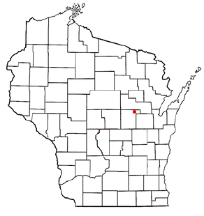
Larrabee is a town in Waupaca County, Wisconsin, United States. The population was 1,301 at the 2000 census. The unincorporated community of Buckbee is located in the town.

<span class="mw-page-title-main">Poygan, Wisconsin</span> Town in Wisconsin, United States

Poygan is a town in Winnebago County, Wisconsin, United States. The population was 1,301 at the 2010 census.

<span class="mw-page-title-main">Gilman City, Missouri</span> City in Missouri, United States

Gilman City is a city in southeastern Harrison and extending into northeastern Daviess counties in the U.S. state of Missouri. The population was 329 at the 2020 census.

<span class="mw-page-title-main">Beaver Dam (town), Wisconsin</span> Town in Wisconsin, United States

Beaver Dam is a town in Dodge County, Wisconsin, United States. The population was 3,440 at the 2000 census. The City of Beaver Dam is encircled by the town. The unincorporated communities of Beaver Edge, Leipsig and Sunset Beach are located in the town. The ghost town of Clason Prairie was also located in the town.

Lowell is a town in Dodge County, Wisconsin, United States. The population was 1,169 at the 2000 census. The Village of Lowell and the unincorporated community of North Lowell are located in the town.

References

  1. 1 2 "US Board on Geographic Names". United States Geological Survey. October 25, 2007. Retrieved January 31, 2008.
  2. 1 2 "U.S. Census website". United States Census Bureau . Retrieved January 31, 2008.