Neosho, Wisconsin

Last updated

Neosho, Wisconsin
Neosho Wisconsin Downtown Looking South WIS67.jpg
Looking south in Neosho
Dodge County Wisconsin Incorporated and Unincorporated areas Neosho Highlighted.svg
Location of Neosho in Dodge County, Wisconsin.
Coordinates: 43°18′37″N88°31′5″W / 43.31028°N 88.51806°W / 43.31028; -88.51806
Country Flag of the United States.svg  United States
State Flag of Wisconsin.svg  Wisconsin
County Dodge
Area
[1]
  Total0.56 sq mi (1.44 km2)
  Land0.53 sq mi (1.36 km2)
  Water0.03 sq mi (0.08 km2)
Elevation
[2]
902 ft (275 m)
Population
 (2010) [3]
  Total574
  Estimate 
(2019) [4]
551
  Density1,047.53/sq mi (404.49/km2)
Time zone UTC-6 (Central (CST))
  Summer (DST) UTC-5 (CDT)
FIPS code 55-56075 [5]
GNIS feature ID1570176 [2]
Website www.villageofneosho.org

Neosho is a village in Dodge County, Wisconsin, United States. The population was 574 at the 2010 census.

Contents

Geography

Neosho is located at 43°18′37″N88°31′5″W / 43.31028°N 88.51806°W / 43.31028; -88.51806 (43.310165, -88.517933). [6]

According to the United States Census Bureau, the village has a total area of 0.55 square miles (1.42 km2), of which, 0.52 square miles (1.35 km2) of it is land and 0.03 square miles (0.08 km2) is water. [7]

Demographics

Historical population
CensusPop.Note
1880 197
1910 304
1920 296−2.6%
1930 262−11.5%
1940 255−2.7%
1950 28712.5%
1960 34520.2%
1970 40015.9%
1980 57543.8%
1990 65814.4%
2000 593−9.9%
2010 574−3.2%
2019 (est.)551 [4] −4.0%
U.S. Decennial Census [8]

2010 census

As of the census [3] of 2010, there were 574 people, 241 households, and 154 families living in the village. The population density was 1,103.8 inhabitants per square mile (426.2/km2). There were 255 housing units at an average density of 490.4 per square mile (189.3/km2). The racial makeup of the village was 97.2% White, 0.5% African American, 0.7% Native American, 0.2% Asian, and 1.4% from two or more races. Hispanic or Latino of any race were 0.7% of the population.

There were 241 households, of which 29.0% had children under the age of 18 living with them, 49.8% were married couples living together, 9.1% had a female householder with no husband present, 5.0% had a male householder with no wife present, and 36.1% were non-families. 27.4% of all households were made up of individuals, and 5.4% had someone living alone who was 65 years of age or older. The average household size was 2.38 and the average family size was 2.93.

The median age in the village was 42 years. 22.5% of residents were under the age of 18; 7.2% were between the ages of 18 and 24; 27% were from 25 to 44; 34% were from 45 to 64; and 9.1% were 65 years of age or older. The gender makeup of the village was 52.3% male and 47.7% female.

2000 census

As of the census [5] of 2000, there were 593 people, 213 households, and 156 families living in the village. The population density was 991.4 people per square mile (381.6/km2). There were 223 housing units at an average density of 372.8 per square mile (143.5/km2). The racial makeup of the village was 98.99% White, 0.67% Native American, and 0.34% from two or more races. Hispanic or Latino of any race were 0.51% of the population.

There were 213 households, out of which 44.6% had children under the age of 18 living with them, 62.4% were married couples living together, 6.1% had a female householder with no husband present, and 26.3% were non-families. 18.8% of all households were made up of individuals, and 7.5% had someone living alone who was 65 years of age or older. The average household size was 2.78 and the average family size was 3.25.

In the village, the population was spread out, with 30.2% under the age of 18, 9.4% from 18 to 24, 32.2% from 25 to 44, 20.9% from 45 to 64, and 7.3% who were 65 years of age or older. The median age was 34 years. For every 100 females, there were 99.7 males. For every 100 females age 18 and over, there were 102.0 males.

The median income for a household in the village was $50,167, and the median income for a family was $50,167. Males had a median income of $38,000 versus $27,031 for females. The per capita income for the village was $19,134. About 0.6% of families and 1.8% of the population were below the poverty line, including 2.2% of those under age 18 and 5.8% of those age 65 or over.

Notable people

Images

Related Research Articles

<span class="mw-page-title-main">Tipton, California</span> Census-designated place in California, United States

Tipton is a census-designated place (CDP) in Tulare County, California, United States. The population was 2,543 at the 2010 census, up from 1,790 at the 2000 census.

Rock Island Arsenal is a census-designated place (CDP) in Rock Island County, Illinois, United States. The population was 149 at the 2010 census. The island contains the Rock Island National Cemetery.

<span class="mw-page-title-main">Neosho Rapids, Kansas</span> City in Lyon County, Kansas

Neosho Rapids is a city in Lyon County, Kansas, United States. As of the 2020 census, the population of the city was 229.

<span class="mw-page-title-main">Neosho Falls, Kansas</span> City in Woodson County, Kansas, United States

Neosho Falls is a city in Woodson County, Kansas, United States. As of the 2020 census, the population of the city was 134.

<span class="mw-page-title-main">Doylestown, Wisconsin</span> Village in Wisconsin, United States

Doylestown is a village in Columbia County, Wisconsin, United States. The population was 297 at the 2010 census. It is part of the Madison Metropolitan Statistical Area.

<span class="mw-page-title-main">Blue River, Wisconsin</span> Village in Wisconsin, United States

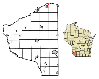
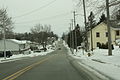
Blue River is a village in Grant County, Wisconsin, United States. The population was 434 at the 2010 census.

<span class="mw-page-title-main">Monticello, Green County, Wisconsin</span> Village in Wisconsin, United States

Monticello is a village in Green County, Wisconsin, United States. The population was 1,217 as of the 2010 census.

<span class="mw-page-title-main">Taylor, Wisconsin</span> Village in Wisconsin, United States

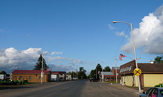
Taylor is a village in Jackson County, Wisconsin, United States, along the Trempealeau River. The population was 484 at the 2020 census.

<span class="mw-page-title-main">Sheldon, Rusk County, Wisconsin</span> Village in Wisconsin, United States

Sheldon is a village in Rusk County, Wisconsin, United States. The population was 237 at the 2010 census.

<span class="mw-page-title-main">Big Falls, Waupaca County, Wisconsin</span> Village in Wisconsin, United States

Big Falls is a village in Waupaca County, Wisconsin, United States. The population was 61 at the 2010 census.

<span class="mw-page-title-main">Viola, Wisconsin</span> Village in Wisconsin, United States

Viola is a village in Richland (mostly) and Vernon counties in the U.S. state of Wisconsin. The population was 699 at the 2010 census. Of this, 477 were in Richland County, and 222 were in Vernon County.

<span class="mw-page-title-main">Unity, Wisconsin</span> Village in Wisconsin, United States

Unity is a village in Clark and Marathon counties in the U.S. state of Wisconsin. It is part of the Wausau, Wisconsin Metropolitan Statistical Area. The population was 343 at the 2010 census. Of this, 204 were in Marathon County, and 139 were in Clark County. The village is located in northeastern town of Unity in Clark County and northwestern town of Brighton in Marathon County.

<span class="mw-page-title-main">Wyocena, Wisconsin</span> Village in Wisconsin, United States

Wyocena is a village in Columbia County, Wisconsin, United States. The population was 768 at the 2010 census. The village is located within the Town of Wyocena. It is part of the Madison Metropolitan Statistical Area.

<span class="mw-page-title-main">Lowell, Wisconsin</span> Village in Wisconsin, United States

Lowell is a village in Dodge County, Wisconsin, United States, along the Beaver Dam River. The population was 340 at the 2010 census. The village is located within the Town of Lowell.

<span class="mw-page-title-main">Colfax, Wisconsin</span> Village in Wisconsin, United States

Colfax is a village in Dunn County, Wisconsin, United States. The population was 1,158 at the 2010 census. The village is surrounded by the Town of Colfax.

<span class="mw-page-title-main">Eden, Wisconsin</span> Village in Wisconsin, United States

Eden is a village in Fond du Lac County, Wisconsin, United States. The population was 875 at the 2010 census. The village is located within the Town of Eden.

<span class="mw-page-title-main">Mount Hope, Wisconsin</span> Village in Wisconsin, United States

Mount Hope is a village in Grant County, Wisconsin, United States. The population was 225 at the 2010 census. The village is located within the Town of Mount Hope.

<span class="mw-page-title-main">Melrose, Wisconsin</span> Village in Wisconsin, United States

Melrose is a village in Jackson County, Wisconsin, United States. The population was 503 at the 2010 census. The village is located within the Town of Melrose.

<span class="mw-page-title-main">Elderon, Wisconsin</span> Village in Wisconsin, United States

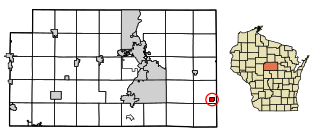
Elderon is a village in Marathon County, Wisconsin, United States. It is part of the Wausau, Wisconsin Metropolitan Statistical Area. The population was 179 at the 2010 census.

<span class="mw-page-title-main">Milltown, Wisconsin</span> Village in Wisconsin, United States

Milltown is a village in Polk County, Wisconsin, United States. The population was 917 at the 2010 census. The village is located within the Town of Milltown.

References

  1. "2019 U.S. Gazetteer Files". United States Census Bureau. Retrieved August 7, 2020.
  2. 1 2 U.S. Geological Survey Geographic Names Information System: Neosho, Wisconsin
  3. 1 2 "U.S. Census website". United States Census Bureau . Retrieved November 18, 2012.
  4. 1 2 "Population and Housing Unit Estimates". United States Census Bureau. May 24, 2020. Retrieved May 27, 2020.
  5. 1 2 "U.S. Census website". United States Census Bureau . Retrieved January 31, 2008.
  6. "US Gazetteer files: 2010, 2000, and 1990". United States Census Bureau. February 12, 2011. Retrieved April 23, 2011.
  7. "US Gazetteer files 2010". United States Census Bureau. Archived from the original on January 25, 2012. Retrieved November 18, 2012.
  8. "Census of Population and Housing". Census.gov. Retrieved June 4, 2015.