Mound Bottom

Last updated
Mound Bottom

Mound Bottom View.jpg

View of the central plaza and platform mound at Mound Bottom, from May's Mace Bluff
USA Tennessee location map.svg
Red pog.svg
Usa edcp location map.svg
Red pog.svg
Location Cheatham County, Tennessee
Coordinates 36°8′23.35″N87°6′4.93″W / 36.1398194°N 87.1013694°W / 36.1398194; -87.1013694 Coordinates: 36°8′23.35″N87°6′4.93″W / 36.1398194°N 87.1013694°W / 36.1398194; -87.1013694
Built 950-1300 CE
NRHP reference # 71000813
Added to NRHP 1971

Mound Bottom is a prehistoric Native American complex in Cheatham County, Tennessee, located in the Southeastern United States. The complex, which consists of earthen platform and burial mounds, a 7-acre central plaza, and habitation areas, was occupied between approximately 1000 and 1300 AD, [1] during the Mississippian period.

Native Americans in the United States Indigenous peoples of the United States (except Hawaii)

Native Americans, also known as American Indians, Indigenous Americans and other terms, are the indigenous peoples of the United States, except Hawaii. There are over 500 federally recognized tribes within the US, about half of which are associated with Indian reservations. The term "American Indian" excludes Native Hawaiians and some Alaska Natives, while Native Americans are American Indians, plus Alaska Natives of all ethnicities. Native Hawaiians are not counted as Native Americans by the US Census, instead being included in the Census grouping of "Native Hawaiian and other Pacific Islander".

Cheatham County, Tennessee County in the United States

Cheatham County is a county located in the U.S. state of Tennessee. As of the 2010 census, the population was 39,105. Its county seat is Ashland City.

Platform mound Earthwork or mound intended to support a structure or activity

A platform mound is any earthwork or mound intended to support a structure or activity.

Contents

The Mound Bottom site is likely associated with another mound complex located just over a mile to the south known as the Pack Site, or Great Mound Division, and together they have been called the "Great Mound Group." Due to structural similarities in the mounds and ceramic chronologies, these sites are believed to have been contemporaneous. [1]

Chronological dating, or simply dating, is the process of attributing to an object or event a date in the past, allowing such object or event to be located in a previously established chronology. This usually requires what is commonly known as a "dating method". Several dating methods exist, depending on different criteria and techniques, and some very well known examples of disciplines using such techniques are, for example, history, archaeology, geology, paleontology, astronomy and even forensic science, since in the latter it is sometimes necessary to investigate the moment in the past in which the death of a cadaver occurred.

Geographical setting

Mound Bottom is situated on a horseshoe bend of the Harpeth River at the river's confluence with Mound Creek, which approaches the riverbank opposite the site from the east. The Mound Bottom bend is one in a series of sharp bends found along the lower Harpeth as the river twists and turns through a steep gorge en route to its confluence with the Cumberland River several miles to the north. The Harpeth surrounds Mound Bottom on the north, south, and east, while the entry to the bend from the west is marked by rocky uplands.

Harpeth River river in the United States of America

The Harpeth River, 115 miles (185 km) long, is one of the major streams of north-central Middle Tennessee, United States, and one of the major tributaries of the Cumberland River. Via the Cumberland and the Ohio Rivers, it is part of the Mississippi River watershed. The lower portion of the Harpeth is designated as a "scenic river" under the Tennessee Scenic Rivers Act.

Cumberland River river in the United States of America

The Cumberland River is a major waterway of the Southern United States. The 688-mile-long (1,107 km) river drains almost 18,000 square miles (47,000 km2) of southern Kentucky and north-central Tennessee. The river flows generally west from a source in the Appalachian Mountains to its confluence with the Ohio River near Paducah, Kentucky, and the mouth of the Tennessee River. Major tributaries include the Obey, Caney Fork, Stones, and Red rivers.

Mound Bottom is today located approximately 1-mile (1.6 km) north of the point where U.S. Route 70 crosses the Harpeth River, on the outskirts of Kingston Springs. The site is managed by the Tennessee Department of Environment and Conservation as part of Harpeth River State Park. Site access is prohibited without accompaniment by park rangers or the Tennessee Division of Archaeology. The Pack Site is located on private property approximately 1.5 miles (2.4 km) southwest of Mound Bottom, just south of US-70, and is not open for visitation.

U.S. Route 70 in Tennessee enters the state of Tennessee from Arkansas via the Memphis & Arkansas Bridge in Memphis, and runs west to east across 21 counties in all three grand divisions of Tennessee, with a total length of 478.48 miles (770.04 km), to end at the North Carolina state line in eastern Cocke County. Along the route, US 70 is accompanied with various U.S. and state highways, including those in three of the state’s four major cities.

Kingston Springs, Tennessee Town in Tennessee, United States

Kingston Springs is a town in Cheatham County, Tennessee, United States. The population was 2,773 at the 2000 census and 2,756 at the 2010 census.

The Tennessee Department of Environment and Conservation (TDEC) is a Cabinet-level agency within the government of the U.S. state of Tennessee, headed by the Tennessee Commissioner of Environment and Conservation.

Archaeological history of Mound Bottom

1923 map of Mound bottom prepared by Crawford C. Anderson 1923 map of Mound bottom.jpg
1923 map of Mound bottom prepared by Crawford C. Anderson

Together the Mound Bottom site and Pack Site contain up to 34 earthen mounds, including between 11 and 14 at Mound Bottom and 20 at Pack. [1] Some of these are flat-topped platform mounds that supported structures including ceremonial buildings or elite residences, while others were burial mounds. [2] At Mound Bottom, the principal large flat-topped mound and up to 13 additional smaller mounds were arranged around a central plaza. The principal mound at Mound Bottom originally stood at least 36 feet tall and measured about 246 feet along each side of its base, and is oriented approximately 11 degrees east of north. [3] [4] The mound summit was originally accessed via a ramp or staircase located at the midpoint of the eastern face. According to early historical reports the Mound Bottom complex was surrounded by an earthen wall topped with a palisade of upright logs. [5] However, any sign of the palisade had been plowed away by the early 1920s. [6] In addition to the earthen, mounds, the site also included hundreds of houses, cemeteries, and agricultural fields.

Palisade defensive structure; typically a fence or wall made from wooden stakes

A palisade—sometimes called a stakewall or a paling—is typically a fence or wall made from iron or wooden stakes, or tree trunks and used as a defensive structure or enclosure.

The late prehistoric Native American culture of the Nashville Basin has been referenced in older and non-scholarly sources as being either the Mound Builders or the Stone Graves Race. Today archaeologists understand that Mound Bottom, Pack, and other late prehistoric mound sites in the area surrounding Nashville were constructed by a regional Mississippian culture known as Middle Cumberland Mississippian. [7] This regional culture was first defined in the 1970s based on distinctive mortuary offerings and the presence of stone box burials, and has since been refined using ceramic typologies [8] A recent reassessment of the Middle Cumberland Mississippian by Moore and Smith [7] resulted in a revised chronology and new understanding of Mound Bottom's placement in the regional cultural sequence. Both Mound Bottom and Pack appear to have been initially established early in the Mississippian period (ca. A.D. 1000) by individuals from outside the region. Based on artifact types and skeletal examinations, it appears these founders may have come from the American Bottom, and possibly from the site of Cahokia. [1] [7] [9] As a result of this connection, the Middle Cumberland Culture in Tennessee was part of the larger Mississippian Ideological Interaction Sphere (previously known as the Southern Cult and Southeastern Ceremonial Complex), which connected late prehistoric cultures from the Great Lakes, Gulf Coast, and the Appalachian Mountains. [2] [10]

The Nashville Basin, also known as the Central Basin, is a term often used to describe the area surrounding Nashville, Tennessee. The Central Basin was caused by an uplifting which produced a dome known as the Nashville Dome. The Nashville Dome is evidenced by the underlying rock strata that all dip downwards away from Nashville. The uplifting of the Nashville Dome fractured overlying strata, making it more easily eroded and thus the "dome" resulted in a "basin". Uplifted strata in the center of a geological dome have higher potential erosive energy than the surrounding strata, because they are physically higher. Erosion thus acts on the uplifted area at a greater rate than on the surrounding flat-lying area, creating a low area, i.e. a basin. This area is more correctly referred to as the "Central Dome" of Tennessee.

Mound Builders Pre-Columbian cultures of North America that constructed various styles of earthen mounds

The various cultures collectively termed "Mound Builders" were inhabitants of North America who, during a circa 5,000-year period, constructed various styles of earthen mounds for religious, ceremonial, burial, and elite residential purposes. These included the pre-Columbian cultures of the Archaic period, Woodland period, and Mississippian period; dating from roughly 3500 BCE to the 16th century CE, and living in regions of the Great Lakes, the Ohio River Valley, and the Mississippi River valley and its tributary waters.

Mississippian culture Mound-building Native American culture in Midwestern, Eastern, and Southeastern United States

The Mississippian culture was a mound-building Native American civilization archeologists date from about 800 CE to 1600 CE, varying regionally.

By A.D. 1350, Mound Bottom and Pack appear to have been abandoned as a major centers, and while mound building and repair ceased, both sites continued to be used as burial locations. This change corresponds to a period of apparent political destabilization in the region, as the centralized authority of Mound Bottom and other large early sites gave way to fortified, autonomous village centers. [7] This is followed in turn by a gradual abandonment of the region toward the end of the fourteenth century. According to Moore and Smith (2009, page 210), by A.D. 1475, Mississippian settlement of the region drop well below the level of archaeological visibility. [7]

Mound Bottom in recorded history

THC marker along Cedar Hill Road Mound-bottom-marker.jpg
THC marker along Cedar Hill Road

Early Tennessee historian John Haywood noted Mound Bottom's importance as an aboriginal site in 1823, and early settlers reported seeing large fortifications and towers at the site. In the late 1860s, Joseph Jones of the Smithsonian Institution investigated several prehistoric sites in Tennessee, and reported "extraordinary aboriginal works" at Mound Bottom. [11]

In 1923, William E. Myer, also working with the Smithsonian, carried out the first modern investigation of the Mound Bottom site. Myer uncovered evidence of a structure and hearth atop one of the mounds at the Pack site and evidence of 10 ancient houses at Mound Bottom. Tennessee state archaeologist P.E. Cox followed up on Myer's finds in 1926, uncovering a number of stone box burials and baked clay floors. Parmenio Edward Cox, Tennessee’s first State Archaeologist, conducted a month of fieldwork at Mound Bottom in 1926. Cox excavated at least 70 graves and tested nine mounds No report on those excavations was published. In 1936, 1937, and 1940 the University of Tennessee conducted excavations at both Mound Bottom and the Pack Site under the auspices of the Works Progress Administration. Those excavations were directed by Charles Nash, and examined several cemeteries and a burial mound. [1]

In 1972, the State of Tennessee purchased the Mound Bottom site to preserve it as a state archaeological area. The Tennessee Division of Archaeology dispatched Carl Kuttruff and Michael O'Brien to conduct excavations at Mound Bottom in 1974 and 1975. Kuttruff and O'Brien tested six mounds and 19 houses. The results of those excavations were published in 2012 in the journal Southeastern Archaeology. [4]

In 2005, Mound Bottom became part of Harpeth River State Park, a "linear park" connecting several archaeological, historical, and natural areas along the lower Harpeth. The site is closed to the public, although guided tours are available by request. In 2008 an adjacent 65-acre parcel including additional site area was purchased with the assistance of Tennessee Parks and Greenways Foundation. [3]

Mound Bottom and the adjacent pictograph at May's Mace Bluff were the inspiration for the 2014 Tennessee Archaeology Awareness Month poster, created by the Tennessee Council for Professional Archaeology. [12]

See also

Related Research Articles

Etowah Indian Mounds archaeological site in Bartow County, Georgia

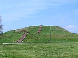
Etowah Indian Mounds (9BR1) are a 54-acre (220,000 m2) archaeological site in Bartow County, Georgia south of Cartersville, in the United States. Built and occupied in three phases, from 1000–1550 AD, the prehistoric site is located on the north shore of the Etowah River. Etowah Indian Mounds Historic Site is a designated National Historic Landmark, managed by the Georgia Department of Natural Resources. It is the most intact Mississippian culture site in the Southeastern United States.

Pinson Mounds Archaeological park

The Pinson Mounds comprise a prehistoric Native American complex located in Madison County, Tennessee in the region that is known as the Eastern Woodlands. The complex, which includes 17 mounds, an earthen geometric enclosure, and numerous habitation areas, was most likely built during the Middle Woodland period. The complex is the largest group of Middle Woodland mounds in the United States. Sauls' Mound, at 72 feet, is the second-highest surviving mound in the United States.

Moundville Archaeological Site Archaeological site

Moundville Archaeological Site, also known as the Moundville Archaeological Park, is a Mississippian culture site on the Black Warrior River in Hale County, near the city of Tuscaloosa, Alabama. Extensive archaeological investigation has shown that the site was the political and ceremonial center of a regionally organized Mississippian culture chiefdom polity between the 11th and 16th centuries. The archaeological park portion of the site is administered by the University of Alabama Museums and encompasses 185 acres (75 ha), consisting of 29 platform mounds around a rectangular plaza.

Shiloh Indian Mounds Site

Shiloh Indian Mounds Site (40HR7) is an archaeological site of the South Appalachian Mississippian culture. It is located beside the Tennessee River on the grounds of the Shiloh National Military Park, in Hardin County of southwestern Tennessee. A National Historic Landmark, it is one of the largest Woodland era sites in the southeastern United States.

Nacoochee Mound archaeological site in Georgia, US

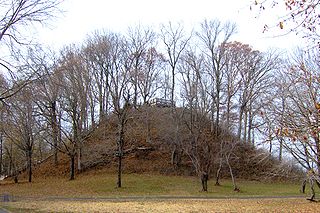
The Nacoochee Mound is an archaeological site on the banks of the Chattahoochee River in White County, in the northeast part of the U.S. state of Georgia, at the junction of Georgia State Route 17 and Georgia State Route 75. First occupied as early as 100-500 CE, the site was later developed and occupied more intensively by peoples of the South Appalachian Mississippian culture from 1350 to 1600 CE. One of their characteristic platform mounds is located at the site. A professional archeological excavation revealed a total of 75 human burials, with artifacts that support dating of the site.

Kincaid Mounds State Historic Site Archaeological site in Illinois, US

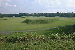
The Kincaid Mounds Historic Site c. 1050–1400 CE, is the site of a city from the prehistoric Mississippian culture. One of the largest settlements of the Mississippian culture, it was located at the southern tip of present-day U.S. state of Illinois. Kincaid Mounds has been notable for both its significant role in native North American prehistory and for the central role the site has played in the development of modern archaeological techniques. The site had at least 11 substructure platform mounds. Artifacts from the settlement link its major habitation and the construction of the mounds to the Mississippian period, but it was also occupied earlier during the Woodland period.

Old Stone Fort (Tennessee) Archaeological site

The Old Stone Fort is a prehistoric Native American structure located in Coffee County, Tennessee, in the Southeastern United States. The structure was most likely built between 80 and 550 AD during the Middle Woodland period. It is the most complex hilltop enclosure found in the South and was likely used for ceremonial purposes rather than defense.

Tomotley

Tomotley is a prehistoric and historic Native American site in Monroe County, Tennessee, in the southeastern United States. Occupied as early as the Archaic period, the Tomotley site had the most substantial periods of habitation during the Mississippian period, likely when the earthwork mounds were built and later during the mid to late eighteenth century as a refugee village of Cherokee from the Lower, Middle and Valley towns.

Old Town (Franklin, Tennessee) archaeological site in Williamson County, Tennessee near Franklin

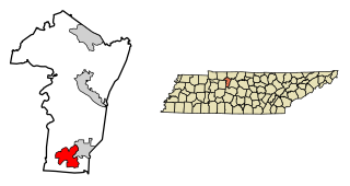
Old Town is an archaeological site in Williamson County, Tennessee near Franklin. The site includes the remnants of a Native American village and mound complex of the Mississippian culture, and is listed on the National Register of Historic Places (NRHP) as Old Town Archaeological Site (40WM2).

Tolu Site

The Tolu Site is a prehistoric archeological site of the Mississippian culture near the unincorporated community of Tolu, Crittenden County, Kentucky, United States. It was built and occupied between 1200-1450 CE. No carbon dating has been performed at the site, but analysis of pottery styles suggest its major habitation period was 1200 to 1300 CE. The site originally had three mounds, a burial mound, a substructure platform mound and one other of undetermined function. It was excavated in 1930 by W.S. Webb and W.D. Funkhouser.

Castalian Springs Mound Site

The Castalian Springs Mound State Historic Site (40SU14) is a Mississippian culture archaeological site located near the small unincorporated community of Castalian Springs in Sumner County, Tennessee. The site was first excavated in the 1890s and again as recently as the 2005 to 2011 archaeological field school led by Dr. Kevin E. Smith. A number of important finds have been associated with the site, most particularly several examples of Mississippian stone statuary and the Castalian Springs shell gorget held by the National Museum of the American Indian. The site is owned by the State of Tennessee and is a State Historic Site managed by the Bledsoe's Lick Association for the Tennessee Historical Commission. The site is not currently open to the public.

Beasley Mounds Site

The Beasley Mounds Site (40SM43) is a Mississippian culture archaeological site located at the confluence of Dixon Creek and the Cumberland River near the unincorporated community of Dixon Springs in Smith County, Tennessee. The site was first excavated by amateur archaeologists in the 1890s. More examples of Mississippian stone statuary have been found at the site than any other in the Middle Tennessee area. The site was listed on the National Register of Historic Places in 2010.

Brick Church Mound and Village Site

The Brick Church Mound and Village Site (40DV39) is a Mississippian culture archaeological site located in Nashville in Davidson County, Tennessee. It was excavated in the late nineteenth century by Frederic Ward Putnam. During excavations in the early 1970s the site produced a unique cache of ceramic figurines very similar in style to Mississippian stone statuary which are now on display at the Frank H. McClung Museum. It was added to the National Register of Historic Places (NRHP) on May 7, 1973 as NRIS number 73001759 although this did not save the site from being almost totally destroyed by residential development.

Stone box grave

Stone box graves were a method of burial employed by Native Americans of the Mississippian culture in the American Midwest and Southeast. Their construction was especially common in the Cumberland River Basin around Nashville, Tennessee

Fewkes Group Archaeological Site prehistoric Native American archaeological site

Fewkes Group Archaeological Site, also known as the Boiling Springs Site, is a pre American history Native American archaeological site located in the city of Brentwood, in Williamson County, Tennessee. It is in Primm Historic Park on the grounds of Boiling Spring Academy, a historic schoolhouse established in 1830. The 15-acre site consists of the remains of a late Mississippian culture mound complex and village roughly dating to 1050-1475 AD. The site, which sits on the western bank of the Little Harpeth River, has five mounds, some used for burial and others, including the largest, were ceremonial platform mounds. The village was abandoned for unknown reasons around 1450. The site is named in honor of Dr. J. Walter Fewkes, the Chief of the Bureau of American Ethnology in 1920, who had visited the site and recognized its potential. While it was partially excavated by the landowner in 1895, archaeologist William E. Myer directed a second, more thorough excavation in October 1920. The report of his findings was published in the Bureau of American Ethnology's Forty-First Annual Report. Many of the artifacts recovered from the site are now housed at the Smithsonian Institution. It was added to the National Register of Historic Places on April 21, 1980, as NRIS number 80003880.

Brentwood Library Site library

The Brentwood Library Site, also known as the Jarman Farm Site, is a Mississippian culture archaeological site located in the city of Brentwood, in Williamson County, Tennessee. It was occupied during the Thurston Phase of the local chronology and artifacts from the site have been radiocarbon dated to 1298 to 1465 CE.

McMahan Mound Site

The McMahan Mound Site (40SV1), also known as McMahan Indian Mound, is an archaeological site located in Sevierville, Tennessee just above the confluence of the West Fork and the Little Pigeon Rivers in Sevier County.

References

  1. 1 2 3 4 5 Michael C. Moore, David H. Dye, and Kevin E. Smith, "WPA Excavations at the Mound Bottom and Pack Sites in Middle Tennessee, 1936-1940." In New Deal Archaeology in Tennessee: Intellectual, Methodological, and Theoretical Contributions, edited by David H. Dye, pp. 116-137. University of Alabama Press, 2016.
  2. 1 2 Kevin Smith, "Mound Bottom." The Tennessee Encyclopedia of History and Culture, 2002. Retrieved: 7 December 2007.
  3. 1 2 Aaron Deter-Wolf, "30 Days of Tennessee Archaeology, Day 13: A Visit to Mound Bottom." Tennessee Council for Professional Archaeology, posted 13 September 2014.
  4. 1 2 Michael J. O’Brien and Carl Kuttruff, "Excavations at Mound Bottom, A Palisaded Mississippian Center in Cheatham County, Tennessee," Southeastern Archaeology, (2012) 31:pp. 70-86
  5. Kevin Markuson, "Mound Bottom: Archaeological Treasures in Cheatham County." Tennessee Archaeology Net. Originally published in The Advocate vol. 8, no. 5 (31 January 1998). Retrieved: 7 December 2007.
  6. Wiliam Edward Myer, "Archaeological Field Work in Tennessee," Smithsonian Miscellaneous Collections, 76-1. Washington, DC: Smithsonian Institution. 1924
  7. 1 2 3 4 5 Michael C. Moore and Kevin E. Smith, Archaeological Expeditions of the Peabody Museum in Middle Tennessee, 1877-1884. Tennessee Department of Environment and Conservation, Division of Archaeology, Research Series 16. 2009.
  8. Michael C. Moore, Emanuel Breitburg, Kevin E. Smith, and Mary Beth Trubitt. One Hundred Years of Archaeology at Gordontown: A Fortified Mississippian Town in Middle Tennessee. Southeastern Archaeology 25(1):89–109. 2006.
  9. William O. Autry, "An Example of Intentional Late Prehistoric Dental Mutilation from Middle Tennessee." McClung Museum of Natural History and Culture, posted 1 August 1991.
  10. George E. Lankford, "Regional Approaches to Iconographic Art." In Visualizing the Sacred: Cosmic Visions, Regionalism, and the Art of the Mississippian World, edited by George E. Lankford, F. Kent Reilly III, and James F. Garber, pp. 3-17. 2011, University of Texas Press, Austin.
  11. Joseph Jones, Explorations of the Aboriginal Remains of Tennessee. Smithsonian Contributions to Knowledge 22(259):1–171. Washington DC, 1876
  12. Tanya M. Peres, "30 Days of Tennessee Archaeology, Day 14: The 2014 Tennessee Archaeology Awareness Month Poster!." Tennessee Council for Professional Archaeology, posted 14 September 2014.