Castalian Springs Mound Site

Last updated
Castalian Springs Mound Site
40 SU 14
Cheskiki-mound-tn1.jpg
USA Tennessee location map.svg
Archaeological site icon (red).svg
Location within Tennessee today
Location Castalian Springs, Tennessee,  Sumner County, Tennessee, Flag of the United States.svg  USA
Region Sumner County, Tennessee
Coordinates 36°23′54.96″N86°18′48.60″W / 36.3986000°N 86.3135000°W / 36.3986000; -86.3135000
History
Founded1100 CE
Abandoned1450
Cultures Mississippian culture
Site notes
Excavation dates1891, 1893, 1916-1917, 2005-2011,
Archaeologists William E. Myer, Kevin E. Smith
Architecture
Architectural styles Platform mounds, burial mound, palisade, plaza
Responsible body: State of Tennessee

The Castalian Springs Mound State Historic Site (40SU14) [1] (also known as Bledsoe's Lick Mound and Cheskiki Mound) is a Mississippian culture archaeological site located near the small unincorporated community of Castalian Springs in Sumner County, Tennessee. The site was first excavated in the 1890s and again as recently as the 2005 to 2011 archaeological field school led by Dr. Kevin E. Smith. A number of important finds have been associated with the site, most particularly several examples of Mississippian stone statuary and the Castalian Springs shell gorget held by the National Museum of the American Indian. The site is owned by the State of Tennessee and is a State Historic Site managed by the Bledsoe's Lick Association for the Tennessee Historical Commission. The site is not currently open to the public.

Contents

Site

The Castalian Springs site is the largest of four Mississippian mound centers on the eastern edge of the Nashville basin, located on a flood terrace of a tributary creek of the Cumberland River. [1] It was occupied from 1100 to 1450 CE, [2] with the main occupation dating to 1200-1325 CE. [3] The palisaded village and surrounding habitation area was approximately 40 acres (0.16 km2) in size and consisted of a dozen platform mounds, a burial mound, plaza and a number of dwellings and civic structures. [4] The site was first noted in the early 1820s by Ralph E.W. Earl, who did extensive digging at the site. He described a low earthen embankment with raised earthen towers enclosing 16 acres (0.065 km2), the remnants of what is now known to have been a wooden palisade. Earl also described the principal mound ( Mound 2) inside the enclosure as being a compound structure consisting of a rectangular platform 600 feet (180 m) long by 200 feet (61 m) wide and 13 feet (4.0 m) to 15 feet (4.6 m) in height and aligned in an east-west direction. On the western end of the platform was a conical shaped mound with a flattened top, approximately 18 feet (5.5 m) to 20 feet (6.1 m) in height. [5] On the southern side of the mound was a plaza, which was bordered on its eastern edge by a 120 feet (37 m) in diameter 8 feet (2.4 m) tall burial mound (Mound 1) and on its western edge by another large platform mound (Mound 3). Outside of the palisade to southwest on the banks of Lick Creek was a stone mound (Mound 4) 60 feet (18 m) in diameter and 5.5 feet (1.7 m), similar examples of which have been found at the Beasley Mounds and Sellars Indian Mound sites. Over the years since Earls first description Euro-Americans have plowed the area for agricultural purposes and consequently the main platform mound and a few raised impressions are all that are still visible of the embankment and the 12 platform mounds once contained within it. Scattered throughout the area archaeologists have also found stone box graves, mortuary caves and other features thought to be associated with the Castalian Springs site. [1] The karst terrain of the area produced numerous small caves, one of which is located a few hundred yards west of the Castalian Springs site. Known locally as the "Cave of the Skulls" (40SU126), this small cave was explored by Myer at sometime during one of his three excavation of the site. [6]

Excavations

In the early 1890s and again in 1916-1917, amateur archaeologist William E. Myer (later a “special archeologist” with the Smithsonian [7] ) excavated parts of the site, including the stone box graves. He also excavated the large burial mound, which contained well over a hundred graves. [8] Myer discovered several artifacts containing S.E.C.C. imagery, including many shell gorgets which were later acquired by the Museum of the American Indian in 1926. [9]

The State of Tennessee purchased the site in 2005, and modern excavations were instituted by the Middle Tennessee State University. Dr. Kevin E. Smith conducted an archaeological dig school at the village site from 2005 through 2011. [5] [10] The Castalian Springs Archaeological Project is a multi-year research project sponsored by the Department of Sociology and Anthropology at Middle Tennessee State University, the Bledsoe's Lick Historical Association and the Tennessee Division of Archaeology. Its stated objectives are to develop an initial understanding of the size and extent of the site, to develop trails and other facilities on the site without negatively impacting archaeological deposits, to give university students training in the methods and techniques of professional field and laboratory archaeology, and to emphasize to the public the value of archaeological research. [11]

Important finds

A number of Mississippian stone statues have been dug up at the site, the first being sometime before 1823 when it is first mentioned. Since then several others have been found, including one believed to have been dug from the platform section of the main mound and several from one of the associated village areas. [1] In 1892 an etched stone tablet was discovered at the site by Myer. The 9 inches (23 cm) by 12 inches (30 cm) limestone tablet is engraved with symbolic imagery associated with the S.E.C.C., specifically the upper torso of a human figure ceremonially dressed as a raptorial bird with a sun symbol on its chest. The iconography is very similar to depictions of the falcon dancer found on Mississippian copper plates excavated from locations across the Midwest and Southeast. The tablet was the second of only six such tablets that have been found in the Central Tennessee area. [12] Another more famous engraved stone, the Thruston tablet, was found a short distance away from Castalian Springs site in 1878 on the banks of Rocky Creek in what is now Trousdale County, Tennessee. The tablet is 19 inches (48 cm) wide by 14 inches (36 cm) tall by 1 inch (2.5 cm) and on both sides depicts multiple figures dressed in S.E.C.C. regalia. It is named for Gates P. Thruston, a Nashville lawyer turned avocational archaeologist who excavated many sites in the Nashville area and built up an extensive collection of artifacts, even though he did not discover the stone nor was it ever part of his collection. He did champion the stone and wrote an article for "The Antiquities of Tennessee and the Adjacent States" journal in 1890 when the tablet was held by the Tennessee Historical Society. It is presently part of the collection of the Tennessee State Museum in Nashville. [3]

Myer also found a cache of over thirty [13] engraved shell gorgets, several of which are now held by the N.M.A.I. The most important of the gorgets is carved in what is known as the Eddyville or Braden style , believed to have been associated with the Cahokia polity near Collinsville, Illinois. The gorget depicts a warrior figure holding a ceremonial mace in his left hand and severed head in his right. The figure also has the Forked Eye Surround Motif, the Bellows apron motif and the Bi-Lobed Arrow Motif, all of which are associated with the S.E.C.C. Falcon dancer. Although the design is often shown with the figure upright, holes drilled in the edge of the gorget for its suspension as a neck ornament show it was meant to be seen with the figure oriented sideways, although it is as yet unclear what this may signify. [14] Also in the cache were two Cox style and two Nashville I style gorgets. [13] [15]

In 2005 a waterline replacement crew working on the right of way of State Route 25 discovered an intact Cox style gorget carved from a dark gray shale. This artifact is one of a very few Cox style motifs utilized on a material other than marine shell. [13] The Castalian Springs site is also one of only three sites in Middle Tennessee where ceramic sherds of a type known as Angel negative painted have been found. This type of Mississippian culture pottery is typically associated with Angel Phase sites along the Ohio River. [16]

See also

Related Research Articles

Southeastern Ceremonial Complex

The Southeastern Ceremonial Complex, aka S.E.C.C., is the name given to the regional stylistic similarity of artifacts, iconography, ceremonies, and mythology of the Mississippian culture. It coincided with their adoption of maize agriculture and chiefdom-level complex social organization from 1200 to 1650 CE. Due to some similarities between S.E.C.C. and contemporary Mesoamerican cultures, scholars from the late 1800s to mid-1900s suspected there was a connection between the two locations. But, later research indicates the two cultures have no direct links and that their civilizations developed independently.

Spiro Mounds United States historic place

Spiro Mounds is an archaeological site located in present-day eastern Oklahoma that remains from an indigenous Indian culture that was part of the major northern Caddoan Mississippian culture. The 80-acre site is located within a floodplain on the southern side of the Arkansas River. The modern town of Spiro developed approximately seven miles to the south.

Bledsoes Station United States historic place

Bledsoe's Station, also known as Bledsoe's Fort, was an 18th-century, fortified, frontier, white settlement located in what is now Castalian Springs, Tennessee. The fort was built by long hunter and Sumner County pioneer Isaac Bledsoe in the early 1780s to protect Upper Cumberland settlers and migrants from hostile Native American attacks. While the fort is no longer standing, its location has been verified by archaeological excavations. The site is now part of Bledsoe's Fort Historical Park, a public park established in 1989 by Sumner County residents and Bledsoe's descendants.

Kincaid Mounds State Historic Site Archaeological site in Illinois, US

The Kincaid Mounds Historic Site c. 1050–1400 CE, is a Mississippian culture archaeological site located at the southern tip of present-day U.S. state of Illinois, along the Ohio River. Kincaid Mounds has been notable for both its significant role in native North American prehistory and for the central role the site has played in the development of modern archaeological techniques. The site had at least 11 substructure platform mounds, and 8 other monuments.

Mound Bottom United States historic place

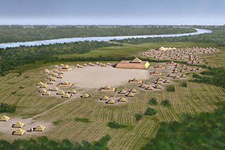
Mound Bottom is a prehistoric Native American complex in Cheatham County, Tennessee, located in the Southeastern United States. The complex, which consists of earthen platform and burial mounds, a 7-acre central plaza, and habitation areas, was occupied between approximately 1000 and 1300 AD, during the Mississippian period.

Castalian Springs, Tennessee Census-designated place in Tennessee, United States

Castalian Springs is an unincorporated community and census-designated place (CDP) in Sumner County, Tennessee, United States. It is located along Tennessee State Route 25, about seven miles east of Gallatin. The area has its own United States post office, designated by the Zip code 37031. In the early 19th century, it was known locally as Bledsoe's Lick, and was the location of Bledsoe's Station, a fortified trading post. As of the 2010 census, its population was 556.

The Pisgah Phase is an archaeological phase of the South Appalachian Mississippian culture in Southeast North America. It is associated with the Appalachian Summit area of southeastern Tennessee, Western North Carolina, and northwestern South Carolina in what is now the United States.

Bledsoe Creek State Park State-protected area of Tennessee, United States

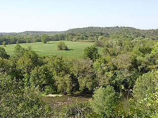
Bledsoe Creek State Park is a state park in Sumner County, Tennessee, in the southeastern United States. The park consists of 169 acres (0.68 km2) managed by the Tennessee Department of Environment and Conservation. The park spans much of the west shore of the Bledsoe Creek embayment of Old Hickory Lake, an impoundment of the Cumberland River created with the completion of Old Hickory Dam by the U.S. Army Corps of Engineers in 1954.

Old Town (Franklin, Tennessee)

Old Town is an archaeological site in Williamson County, Tennessee near Franklin. The site includes the remnants of a Native American village and mound complex of the Mississippian culture, and is listed on the National Register of Historic Places (NRHP) as Old Town Archaeological Site (40WM2).

Garden Creek site

Garden Creek site is an archaeological site located 24 miles (39 km) west of Asheville, North Carolina in Haywood County, on the south side of the Pigeon River and near the confluence of its tributary Garden Creek. It is near modern Canton and the Pisgah National Forest. The earliest human occupation at the site dates to 8000 BCE.

Shell gorget

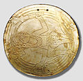
Shell gorgets are a Native American art form of polished, carved shell pendants worn around the neck. The gorgets are frequently engraved, and are sometimes highlighted with pigments, or fenestrated.

Beasley Mounds Site

The Beasley Mounds Site (40SM43) is a Mississippian culture archaeological site located at the confluence of Dixon Creek and the Cumberland River near the unincorporated community of Dixon Springs in Smith County, Tennessee. The site was first excavated by amateur archaeologists in the 1890s. More examples of Mississippian stone statuary have been found at the site than any other in the Middle Tennessee area. The site was listed on the National Register of Historic Places in 2010.

Brick Church Mound and Village Site

The Brick Church Mound and Village Site (40DV39) is a Mississippian culture archaeological site located in Nashville in Davidson County, Tennessee. It was excavated in the late nineteenth century by Frederic Ward Putnam. During excavations in the early 1970s the site produced a unique cache of ceramic figurines very similar in style to Mississippian stone statuary which are now on display at the Frank H. McClung Museum. It was added to the National Register of Historic Places (NRHP) on May 7, 1973 as NRIS number 73001759 although this did not save the site from being almost totally destroyed by residential development.

Stone box graves were a method of burial used by Native Americans of the Mississippian culture in the Midwestern United States and the Southeastern United States. Their construction was especially common in the Cumberland River Basin, in settlements found around present-day Nashville, Tennessee.

Fewkes Group Archaeological Site

Fewkes Group Archaeological Site, also known as the Boiling Springs Site, is a pre American history Native American archaeological site located in the city of Brentwood, in Williamson County, Tennessee. It is in Primm Historic Park on the grounds of Boiling Spring Academy, a historic schoolhouse established in 1830. The 15-acre site consists of the remains of a late Mississippian culture mound complex and village roughly dating to 1050-1475 AD. The site, which sits on the western bank of the Little Harpeth River, has five mounds, some used for burial and others, including the largest, were ceremonial platform mounds. The village was abandoned for unknown reasons around 1450. The site is named in honor of Dr. J. Walter Fewkes, the Chief of the Bureau of American Ethnology in 1920, who had visited the site and recognized its potential. While it was partially excavated by the landowner in 1895, archaeologist William E. Myer directed a second, more thorough excavation in October 1920. The report of his findings was published in the Bureau of American Ethnology's Forty-First Annual Report. Many of the artifacts recovered from the site are now housed at the Smithsonian Institution. It was added to the National Register of Historic Places on April 21, 1980, as NRIS number 80003880.

Brentwood Library Site

The Brentwood Library Site (40WM210), also known as the Jarman Farm Site, is a Mississippian culture archaeological site located in the city of Brentwood, in Williamson County, Tennessee. The substantial town was occupied during Regional Period IV of the local Mississippian chronology, and there was an associated burial ground, where nearly 50 stone box graves have been found. Artifacts from the site have been radiocarbon dated to between 1298 to 1465 CE. These include several types of Mississippian pottery, with Beckwith Incised found in the highest number.

Little Egypt (archaeological site)

The Little Egypt site was an archaeological site located in Murray County, Georgia, near the junction of the Coosawattee River and Talking Rock Creek. The site originally had three platform mounds surrounding a plaza and a large village area. It was destroyed during the construction of the Dam of Carters Lake in 1972. It was situated between the Ridge and Valley and Piedmont sections of the state in a flood plain. Using Mississippian culture pottery found at the site archaeologists dated the site to the Middle and Late South Appalachian culture habitation from 1300 to 1600 CE during the Dallas, Lamar, and Mouse Creek phases.

Savannah Archaeological Site

The Savannah Archaeological Site in Hardin County, Tennessee, is a prehistoric complex of platform mounds and village of the South Appalachian Mississippian culture, a regional variation of Mississippian culture.

McMahan Mound Site

The McMahan Mound Site (40SV1), also known as McMahan Indian Mound, is an archaeological site located in Sevierville, Tennessee just above the confluence of the West Fork and the Little Pigeon rivers in Sevier County.

Hiwassee Island, also known as Jollys Island and Benham Island, is located in Meigs County, Tennessee, at the confluence of the Tennessee and Hiwassee Rivers. It is about 35 miles northeast of Chattanooga. The island was the second largest land mass on the Tennessee River at 781 acres before the Tennessee Valley Authority created the Chickamauga Lake as a part of the dam system on the Tennessee River in 1940. Much of the island is now submerged, leaving 400 acres above the waterline.

References

  1. 1 2 3 4 Smith, Kevin E.; Miller, James V. (2009). Speaking with the Ancestors-Mississippian Stone Statuary of the Tennessee-Cumberland region. University of Alabama Press. pp. 68–77. ISBN   978-0-8173-5465-7.
  2. "Bledsoe's Lick Historical Association" . Retrieved 2011-02-17.
  3. 1 2 Steponaitis, Vincas P.; Knight, Vernon James Jr.; Lankford, George E.; Sharp, Robert V.; Dye, David H. (2011). "Iconography of the Thruston Tablet". Visualing the Sacred : Cosmic Visions, Reglonalism, and the Art of the Mississippian World (PDF). University of Texas Press. ISBN   978-0292723085.
  4. "Historical Background of Bledsoe's Lick". Bledsoe's Lick Archaeological Project. Archived from the original on 2011-05-03. Retrieved 2011-02-17.
  5. 1 2 "Castalian Springs Mound" . Retrieved 2011-02-17.
  6. Smith, Kevin E.; Beahm, Emily L. (Summer 2009). "Corrected provenance for the Long-nosed god mask from "A cave near Rogana, Tennessee"". Southeastern Archaeology. 28 (1): 117–121. JSTOR   40713503.
  7. "Tennessee Treasures-Archaeologist William Myer" . Retrieved 2011-02-17.,
  8. Thruston, Gates Phillips (1890) [1897]. The Antiquities of Tennessee and the Adjacent States, and the State of Aboriginal Society in the Scale of Civilization Represented by Them: A Series of Historical and Ethnological Studies. NABU PR. p.  352. ISBN   978-1-146-35185-0.
  9. "National Museum of the American Indian-gorget detail". Smithsonian National Museum of the American Indian. Retrieved 2011-02-17.
  10. "Tennessee's Prehistory Revealed at Mineral Springs" . Retrieved 2011-02-17.
  11. "Castalian Springs Archaeological Project". Archived from the original on December 25, 2010. Retrieved 2011-02-18.
  12. Loos, Ralph (January–February 2007), Price, Hoyt B. (ed.), Missing slab could unlock mysteries of past:Ancient artifact from east Nashville has unique etching (PDF), Stones and Bones, vol. 49, The Alabama Archaeological Society, archived from the original (PDF) on 2011-02-14
  13. 1 2 3 Moore, Michael C., ed. (Winter 2005). "Editors Corner" (PDF). Tennessee Archaeology. Tennessee Council for Professional Archaeology. 2 (1).
  14. Muller, Jon. "Southeastern Ceremonial Complex"--the "Southern Cult"--a Powerpoint presentation on the web of my paper at the 2000 SAA meeting:Slide 7". Archived from the original on 2011-06-01. Retrieved 2011-02-17.
  15. Muller, Jon (1966). "Other styles in shell gorgets in Aboriginal North America" (PDF). An experimental theory of stylistic analysis (Doctoral thesis). Harvard University.
  16. Smith, Kevin E.; Miller, James V. (2009). Speaking with the Ancestors-Mississippian Stone Statuary of the Tennessee-Cumberland region. University of Alabama Press. pp. 162–163. ISBN   978-0-8173-5465-7.