Fewkes Group Archaeological Site

Last updated

Fewkes Group Archaeological Site
40 WM 1
Fewkes Mounds.JPG
Fewkes Mounds No. 1 & 2. Boiling Spring Academy in the background
USA Tennessee location map.svg
Archaeological site icon (red).svg
Location within Tennessee today
Location Williamson County, Tennessee, Flag of the United States.svg  USA
Region Williamson County, Tennessee
Coordinates 35°58′0.44″N86°46′34.54″W / 35.9667889°N 86.7762611°W / 35.9667889; -86.7762611
History
Founded1050
Abandoned1475
Cultures Mississippian culture
Site notes
Excavation dates1920
Archaeologists William E. Myer
Architecture
Architectural styles burial mounds, platform mounds, plaza
Responsible body: City of Brentwood

Fewkes Group Archaeological Site (40 WM 1), also known as the Boiling Springs Site, [1] is a pre American history Native American archaeological site located in the city of Brentwood, in Williamson County, Tennessee. It is in Primm Historic Park on the grounds of Boiling Spring Academy, a historic schoolhouse established in 1830. The 15-acre site consists of the remains of a late Mississippian culture mound complex and village roughly dating to 1050-1475 AD. [2] The site, which sits on the western bank of the Little Harpeth River, has five mounds, some used for burial and others, including the largest, were ceremonial platform mounds. [3] The village was abandoned for unknown reasons around 1450. [2] The site is named in honor of Dr. J. Walter Fewkes, the Chief of the Bureau of American Ethnology in 1920, who had visited the site and recognized its potential. [4] While it was partially excavated by the landowner in 1895, archaeologist William E. Myer directed a second, more thorough excavation in October 1920. [3] The report of his findings was published in the Bureau of American Ethnology's Forty-First Annual Report. [5] Many of the artifacts recovered from the site are now housed at the Smithsonian Institution. It was added to the National Register of Historic Places on April 21, 1980, as NRIS number 80003880. [6]

Contents

Inhabitants

Two different groups of people lived at the Fewkes Site. The first group, who built the mounds and left the majority of artifacts, buried their dead with their bodies tightly flexed in hexagonal and circular stone box graves. This was probably achieved by tightly binding the body after death, because the bones appear to be in their proper places. [5] These people appear to have lived in circular houses. This occupation dates to the Mississippian period, between 1000 – 1450. [2] A second group moved into the area toward the end of the period. This group buried its dead with the bodies fully extended, on their backs, in rectangular stone box graves. [5] Archaeological research done within the Middle Cumberland River Valley marks a virtual abandonment of the area around 1450. It is unknown what caused this, but the large amount of broken pottery on the floors of their homes may indicate that they were forced to leave in a hurry. [5] This abandonment of the region is part of a larger pattern seen in parts of the Ohio, Mississippi, Tennessee, and Cumberland River valleys known as the "Vacant Quarter" hypothesis. [2] As of 2010, officials at the Tennessee Department of Environment and Conservation, Division of Archaeology, have been unable to identify modern tribal descendants of the inhabitants of the site. [2]

Site description

1920 Map of Fewkes Group Fewkes Map.jpg
1920 Map of Fewkes Group

There are five mounds at the Fewkes site. Four of them are located opposite of each other on each side of a level town plaza, and the fifth (smallest) mound is situated on the riverbank directly to the north of mound No. 1, outside the town center. (Looking at the site today, the Boiling Spring Schoolhouse now sits between mound No.1 and mound No. 5). Mound No. 1 is the largest at the site, being 25 feet (7.6 m) in height. Remnants of about a dozen house circles were found scattered around the outer edges of the group of mounds, mostly between mounds No.1 and No. 5. The most important houses adjoined mound No. 1 on the northeast side. These are represented on the 1920 map by circles. Traces of a stone box cemetery were also found on the property, not far from the mound complex. [5]

Mound No. 1

Mound No. 1 is the largest mound at the complex and is located on the northern side of the town square. The platform mound is 25 feet (7.6 m) and measures 185 feet (56 m) by 160 feet (49 m) across. It was left unexcavated in 1920 because of a lack of funding, although archaeologist William Myer believed its use to be ceremonial, and possibly the location of a chief's residence. [5]

Mound No. 2

Pottery found in Mound No. 2, in the 1920 excavation FewkesPottery.jpg
Pottery found in Mound No. 2, in the 1920 excavation

Mound No. 2 is located on the western side of the plaza. It is 235 feet (72 m) across from north to south, and 160 feet (49 m) across east to west. At the time of excavation it reached 7.5 feet (2.3 m) high. [5] Less than one-fifth of the area of the mound was excavated; because of this, it is impossible to know the number of structures constructed upon it. The mound was raised in four stages. The first level, at the base of the mound, was the original ground surface of the soil. In this layer, archaeologists discovered a fire bed filled with ashes and broken animal bones, indicating that a structure had existed there before the mound was built over top of it. [5] After the house was torn down, the 3 feet (0.91 m) high mound was constructed in its place. On the second level there is evidence that at least one building, and probably more, were constructed. The floor of this structure was packed down and layered with stone slabs, much like pavement. A small pile of maize and maize meal were also found. In the southwestern segment of the mound were found the ruins of a structure, named by Myer the "Sacred Image House" because among the items found were the remains of a sacred idol, a shrine, and traces of fire ceremonies. [5] After the buildings were torn down the mound was raised a few more inches for the third construction level. Many items were found on this level, such as a metate and muller, arrowheads, shell tempered pottery, multiple fire beds, and objects made from deer bones. However, the most important was a structure dubbed the "House of Mysteries". [5] The building was an important civic structure, probably used for sacred rites and town gatherings, and had two rooms. Myers described the floor as being made of "black, glossy earth". [5] The walls and roof of the building were built using the cane matting technique and an arched roof. The woven cane matting was then covered inside and outside with a coating of clay plaster known as wattle and daub. Inside the building was an altar, complete with an oval altar bowl. The bowl, filled with white, powdery ashes, was made of fired red clay. The fire was allowed to burn without being put out. The structure was eventually destroyed by fire. [5] Mound No. 2 was in constant cultivation for at least 85 years, and as a result, only limited structural evidence exists for the final stage. However, numerous postholes indicate that there was a building constructed atop the mound during this phase. It is also important to note that a few burials from the later group of rectangular stone grave people were found close to the surface of Mound No. 2. These were discovered in 1895, when the farmer who owned the land plowed over them and decided to take a closer look. [5]

Mound No. 3

Stone box grave demonstrating flexed burial FlexedSkeleton.jpg
Stone box grave demonstrating flexed burial

Mound No. 3 is a burial mound of the first inhabitants of the Fewkes group. It is a low oval mound on the southwestern corner of the plaza. The mound is about 3 feet (0.91 m) high and 100 feet (30 m) by 110 feet (34 m) across, but slopes very gradually into the soil, so it is impossible to determine its exact boundaries. [5] Originally, it probably held 10-15 graves, but unfortunately all except two have been destroyed by looters and plowing. These two graves were very different from the usual method of burial during the Mississippian period in the Middle Tennessee region. Typically, the deceased were buried on their backs with their legs fully extended, as in a modern-day burial. [5] The remains found in the two graves from this mound had been buried on their backs with their bodies tightly flexed. Their stone-slab graves were octagonal, hexagonal, or nearly round. [5] When the first grave was opened, the slabs on top were missing and the bones had been slightly disturbed, probably by looters. It was octagonal and made from limestone slabs. Grave goods found with the deceased included five large shell beads and a clay pot. The second grave was similar in size to the first, but it was hexagonal. As with the first grave, it had been disturbed by looters and the body was slightly repositioned. The grave goods found with the second set of remains included a small effigy burial vase (somehow overlooked by the looters) and a mussel shell, which was most likely a spoon. [5]

Mound No. 4

Mound No. 4 is located on the east side of the plaza. It is low and oblong, about 4 feet (1.2 m) high, and 200 feet (61 m) by 180 feet (55 m) across. No evidence of fire pits, pottery, or graves were discovered. William Myer believed it to be a natural knoll in the field, given its shape by the removal of soil used for the construction of Mound No. 1. [5] Erosion and years of cultivation have destroyed any evidence of possible of associated structures atop the mound.

Mound No. 5

Mound No. 5 is a small oval mound 32 feet (9.8 m) across and 3.5 feet (1.1 m) high. It is located about 300 feet (91 m) north of Boiling Spring Academy overlooking the bank of the Little Harpeth River. There was no evidence of buildings or burials in this mound, although broken animal bones and pottery fragments were found scattered throughout the soil. [5] Traces of a fire pit and two bone tools were also found.

Structures

Original image of child buried against the fire basin found during a house excavation at Fewkes was removed due to a standing request by Native American tribal members as to not have images of ancestral remains on display to the public. Fewkes Mounds.JPG
Original image of child buried against the fire basin found during a house excavation at Fewkes was removed due to a standing request by Native American tribal members as to not have images of ancestral remains on display to the public.

Many saucer-like depressions were discovered around the north side of Mound No. 1 and in an adjoining field that are thought to be the remains of domestic structures. [5] There is also a large number of these depressions to the west of Mound No. 2 and Mound No. 3. These buildings appear to have been made similarly to the ceremonial buildings found on top of the mounds, with cane matting and plastered walls. [5] Objects found in and around these depressions include bear teeth, arrowheads, broken animal bones, traces of plastered walls, stone disks, and a store of yellow ochre that was most likely used as body paint.

Upon excavation, one circular depression was found to be a nearly smooth, level, hard-packed floor. In the center of this structure was an upright, stone-slab fire basin, one side of which had been cut out; this was to allow room for the upright stone slab of a child's grave. The child, thought to be about 12 years old, was found buried against the slab, with its head resting within the edges of the bowl. [5] Ashes remained in the bowl and also along the back and top of the child's head, although the bones do not appear to have been burned at all. Graves of two other children, whose stone box graves were also found in and below the floor. [5]

Other burials

Two burials were found about 100 feet (30 m) southeast of Mound No. 3. The first was a woman whose body was loosely flexed on her right side. There were no grave goods found. The second burial, located on the woman's right, was simply a pile of bones. There were no grave goods or stone box coffin found in the burial. It is not known if this person had a connection with the deceased woman. Other burials were discovered scattered around the site, from the later group of people who inhabited the area. Grave goods for these burials included conch shells, pottery, spearheads, playing dice crafted from deer bones, and a black stone female statuette. [7]

Excavations in 1998

The remains of at least 21 individuals, along with their funerary objects, were removed from the Fewkes group site during a road construction project by the Tennessee Department of Transportation in 1998. [2] Grave goods removed included ceramic ear plugs, effigy jars, projectile points, a drilled dog tooth and a bone awl. As of April 23, 2010, efforts are being made to reinter the culturally unidentifiable remains from the Fewkes site. [2]

See also

Related Research Articles

<span class="mw-page-title-main">Platform mound</span> Earthwork or mound intended to support a structure or activity

A platform mound is any earthwork or mound intended to support a structure or activity. It typically refers to a flat-topped mound, whose sides may be pyramidal.

<span class="mw-page-title-main">Town Creek Indian Mound</span> National Historic Landmark in North Carolina

Town Creek Indian Mound is a prehistoric Native American archaeological site located near present-day Mount Gilead, Montgomery County, North Carolina, in the United States. The site, whose main features are a platform mound with a surrounding village and wooden defensive palisade, was built by the Pee Dee, a South Appalachian Mississippian culture people that developed in the region as early as 980 CE. They thrived in the Pee Dee River region of North and South Carolina during the Pre-Columbian era. The Town Creek site was an important ceremonial site occupied from about 1150—1400 CE. It was abandoned for unknown reasons. It is the only ceremonial mound and village center of the Pee Dee located within North Carolina.

<span class="mw-page-title-main">Nodena site</span> Archaeological site in Arkansas, United States

The Nodena site is an archeological site east of Wilson, Arkansas, and northeast of Reverie, Tennessee, in Mississippi County, Arkansas, United States. Around 1400–1650 CE an aboriginal palisaded village existed in the Nodena area on a meander bend of the Mississippi River. The Nodena site was discovered and first documented by Dr. James K. Hampson, archaeologist and owner of the plantation on which the Nodena site is located. Artifacts from this site are on display in the Hampson Museum State Park in Wilson, Arkansas. The Nodena site is the type site for the Nodena phase, believed by many archaeologists to be the province of Pacaha visited by Spanish explorer Hernando de Soto in 1542.

<span class="mw-page-title-main">Slack Farm</span>

Slack Farm is an archaeological site of the Caborn-Welborn variant of the Mississippian culture. Slack Farm is located near Uniontown, Kentucky, close to the confluence of the Ohio River and the Wabash Rivers. The site included a Native American mound and an extensive village occupation dating between 1400 and 1650 CE. Although Slack Farm was long known to be one of the major villages of the Caborn-Welborn people, it became famous when it was very seriously damaged by looters in 1987.

<span class="mw-page-title-main">Mound Bottom</span> United States historic place

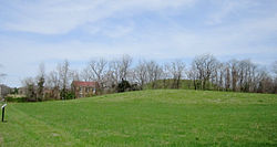
Mound Bottom is a prehistoric Native American complex in Cheatham County, Tennessee, located in the Southeastern United States. The complex, which consists of earthen platform and burial mounds, a 7-acre central plaza, and habitation areas, was occupied between approximately 1000 and 1300 AD, during the Mississippian period.

The Pisgah phase is an archaeological phase of the South Appalachian Mississippian culture in Southeast North America. It is associated with the Appalachian Summit area of southeastern Tennessee, Western North Carolina, and northwestern South Carolina in what is now the United States.

<span class="mw-page-title-main">Upper Mississippian culture</span> Archaeological culture in North America

The Upper Mississippian cultures were located in the Upper Mississippi basin and Great Lakes region of the American Midwest. They were in existence from approximately A.D. 1000 until the Protohistoric and early Historic periods.

<span class="mw-page-title-main">Bussell Island</span> United States historic place

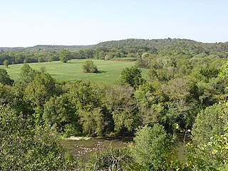
Bussell Island, formerly Lenoir Island, is an island located at the mouth of the Little Tennessee River, at its confluence with the Tennessee River in Loudon County, near the U.S. city of Lenoir City, Tennessee. The island was inhabited by various Native American cultures for thousands of years before the arrival of early European explorers. The Tellico Dam and a recreational area occupy part of the island. Part of the island was added in 1978 to the National Register of Historic Places for its archaeological potential.

<span class="mw-page-title-main">Gahagan Mounds Site</span>

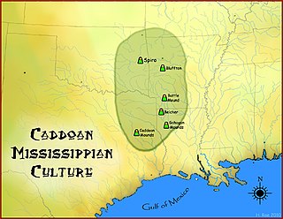
The Gahagan Mounds Site (16RR1) is an Early Caddoan Mississippian culture archaeological site in Red River Parish, Louisiana. It is located in the Red River Valley. The site is famous for the three shaft burials and exotic grave goods excavated there in the early twentieth century.

<span class="mw-page-title-main">Old Town (Franklin, Tennessee)</span>

Old Town is an archaeological site in Williamson County, Tennessee near Franklin. The site includes the remnants of a Native American village and mound complex of the Mississippian culture, and is listed on the National Register of Historic Places (NRHP) as Old Town Archaeological Site (40WM2).

<span class="mw-page-title-main">Castalian Springs Mound Site</span>

The Castalian Springs Mound State Historic Site (40SU14) is a Mississippian culture archaeological site located near the small unincorporated community of Castalian Springs in Sumner County, Tennessee. The site was first excavated in the 1890s and again as recently as the 2005 to 2011 archaeological field school led by Dr. Kevin E. Smith. A number of important finds have been associated with the site, most particularly several examples of Mississippian stone statuary and the Castalian Springs shell gorget held by the National Museum of the American Indian. The site is owned by the State of Tennessee and is a State Historic Site managed by the Bledsoe's Lick Association for the Tennessee Historical Commission. The site is not currently open to the public.

The Beasley Mounds Site (40SM43) is a Mississippian culture archaeological site located at the confluence of Dixon Creek and the Cumberland River near the unincorporated community of Dixon Springs in Smith County, Tennessee. The site was first excavated by amateur archaeologists in the 1890s. More examples of Mississippian stone statuary have been found at the site than any other in the Middle Tennessee area. The site was listed on the National Register of Historic Places in 2010.

<span class="mw-page-title-main">Brick Church Mound and Village Site</span>

The Brick Church Mound and Village Site (40DV39) is a Mississippian culture archaeological site located in Nashville in Davidson County, Tennessee. It was excavated in the late nineteenth century by Frederic Ward Putnam. During excavations in the early 1970s, the site produced a unique cache of ceramic figurines very similar in style to Mississippian stone statuary which are now on display at the Frank H. McClung Museum. It was added to the National Register of Historic Places (NRHP) on May 7, 1973 as NRIS number 73001759 although this did not save the site from being almost totally destroyed by residential development.

Stone box graves were a method of burial used by Native Americans of the Mississippian culture in the Midwestern United States and the Southeastern United States. Their construction was especially common in the Cumberland River Basin, in settlements found around present-day Nashville, Tennessee.

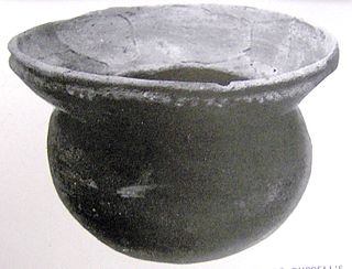
The Brentwood Library Site (40WM210), also known as the Jarman Farm Site, is a Mississippian culture archaeological site located in the city of Brentwood, in Williamson County, Tennessee. The substantial town was occupied during Regional Period IV of the local Mississippian chronology, and there was an associated burial ground, where nearly 50 stone box graves have been found. Artifacts from the site have been radiocarbon dated to between 1298 and 1465 CE. These include several types of Mississippian pottery, with Beckwith Incised found in the highest number.

The Anker Site (11Ck-21) is located on the Little Calumet River near Chicago, Illinois. It is classified as a late prehistoric site with Upper Mississippian Huber affiliation.

The Gentleman Farm site is an archaeological site located in LaSalle County, Illinois, on the Illinois River. It is a multi-component site with the main occupation being a Langford tradition component of Upper Mississippian affiliation.

The Fisher Mound Group is a group of burial mounds with an associated village site located on the DesPlaines River near its convergence with the Kankakee River where they combine to form the Illinois River, in Will County, Illinois, about 60 miles southwest of Chicago. It is a multi-component stratified site representing several Prehistoric Upper Mississippian occupations as well as minor Late Woodland and Early Historic components.

<span class="mw-page-title-main">Walker-Hooper Site</span> Archaeological site in [[Wisconsin]], United States

The Walker-Hooper Site (47-GL-65) is a multicomponent prehistoric site complex located on the Grand River in the Upper Fox River drainage area in Green Lake County, Wisconsin. It consisted of at least 2 village sites and several mound groups. It was excavated by S.A. Barrett under the auspices of the Milwaukee Public Museum in 1921 and again in 1967 by Guy Gibbon of the University of Wisconsin-Milwaukee. The major component of the site is an Upper Mississippian Oneota palisaded village. Other components were also present, mainly Late Woodland but also including Archaic, Early Woodland and Middle Woodland.

Hiwassee Island, also known as Jollys Island and Benham Island, is located in Meigs County, Tennessee, at the confluence of the Tennessee and Hiwassee Rivers. It is about 35 mi (56 km) northeast of Chattanooga. The island was the second largest land mass on the Tennessee River at 781 acres before the Tennessee Valley Authority created the Chickamauga Lake as a part of the dam system on the Tennessee River in 1940. Much of the island is now submerged, leaving 400 acres above the waterline.

References

  1. Peres, Tanya M. (2010). Michael C. Moore (ed.). "Zooarchaeological remains from the 1998 Fewkes Site excavations, Williamson County, Tennessee" (PDF). Tennessee Archaeology. 5 (1). Tennessee Council for Professional Archaeology: 100–125. Archived from the original (PDF) on July 16, 2011. Retrieved April 16, 2011.
  2. 1 2 3 4 5 6 7 Hutt, Sherry (August 3, 2010). "Notice of Inventory Completion: Tennessee Department of Environment and Conservation, Division of Archaeology, Nashville, Tennessee". Federal Register. Retrieved April 11, 2011.
  3. 1 2 Warwick, Rick (2010). Historical Markers of Williamson County Tennessee, Revised: A Pictorial Guide. Nashville, Tennessee: Panacea Press.
  4. Little, Vance (1985). Historic Brentwood. Brentwood, Tennessee: J M Publications.
  5. 1 2 3 4 5 6 7 8 9 10 11 12 13 14 15 16 17 18 19 20 21 22 23 Myer, William (1928). Two Prehistoric Villages in Middle Tennessee. Nashville, Tennessee: Southeastern Indian Antiquities Survey, Inc. pp. 559–610.
  6. "National Register of Historic Places". Archived from the original on August 3, 2012. Retrieved April 16, 2011.
  7. Jones, Joseph (1970). Explorations of the Aboriginal Remains of Tennessee. Knoxville, Tennessee: Tenase Company.