Mount Warren is located in the Wind River Range in the U.S. state of Wyoming. The peak is the third peak in the range and the fourth tallest in Wyoming. The summit is located in the Fitzpatrick Wilderness of Shoshone National Forest and rises above several glaciers, the best known being Dinwoody Glacier which is immediately north of the summit tower. The mountain abuts, but is not within, either Bridger National Forest or Sublette County, Wyoming.

Mount Sacagawea is the eighth-highest peak in the U.S. state of Wyoming and the seventh-highest in the Wind River Range. It was named after Sacagawea, the young Lemhi Shoshone woman who accompanied the Lewis and Clark Expedition as an interpreter and guide. The Upper Fremont Glacier is located southeast and the Sacagawea Glacier is northeast of the mountain. Straddling the Continental Divide, Mount Sacagawea is one mile (1.6 km) northwest of Fremont Peak.
Mount Woodrow Wilson is located in the Wind River Range in the U.S. state of Wyoming. Mount Woodrow Wilson is the eighth-highest mountain in the range and the ninth-highest in Wyoming. The summit is located in the Bridger Wilderness of Bridger-Teton National Forest on the Continental Divide, 1.25 miles (2.01 km) south of Gannett Peak. The flanks of the mountain are covered in snowfields and glaciers, including Dinwoody Glacier to the northeast, Mammoth Glacier to the west and Sphinx Glacier to the south.
Mount Whitecap is located in the northern Wind River Range in the U.S. state of Wyoming. Situated 2.25 mi (3.62 km) southwest of Gannett Peak, Mount Whitecap is in the Bridger Wilderness of Bridger-Teton National Forest. Baby Glacier lies just to the east of the peak and Split Mountain is 1 mi (1.6 km) southeast. Mount Whitecap is the 30th tallest peak in Wyoming.
American Legion Peak is located in the northern Wind River Range in the U.S. state of Wyoming. Situated 1 mi (1.6 km) east of Bow Mountain and a couple miles west of Mount Helen, American Legion Peak is the 17th tallest peak in Wyoming. The small American Legion Glacier descends from the east slopes of the mountain and Henderson Peak lies to the south.
Mount Koven is located in the Wind River Range in the U.S. state of Wyoming. Mount Koven is the 16th highest peak in Wyoming. The summit is on the Continental Divide in both Shoshone and Bridger-Teton National Forests and it is .75 mi (1.21 km) north-northwest of Gannett Peak. The Gannett Glacier flanks the peak to the east, while Minor Glacier is just southwest of the mountain.
Twin Peaks is located in the Wind River Range in the U.S. state of Wyoming. Twin Peaks is the 20th highest peak in Wyoming. Twin Peaks is in the Bridger Wilderness of Bridger-Teton National Forest and is .58 mi (0.93 km) southwest of Mount Woodrow Wilson and about the same distance southeast of Split Mountain. Mammoth Glacier flows from the north slopes of the peak while the smaller Twins Glacier flows to the southeast.
Split Mountain is located in the Wind River Range in the U.S. state of Wyoming. Split Mountain is the 22nd highest peak in Wyoming. Split Mountain is in the Bridger Wilderness of Bridger-Teton National Forest and is about .70 mi (1.13 km) northwest of Twin Peaks and 1 mi (1.6 km) southeast of Mount Whitecap. Mammoth Glacier is on the northeast slopes of the peak while the smaller Baby Glacier flows down from a spur to the northwest.
Bastion Peak-Northeast Peak 13,476 ft (4,107 m) is located in the Wind River Range in the U.S. state of Wyoming. The peak is one of the highest in Wyoming, and is connected to its taller neighbor Bastion Peak by an arête to the southwest. An unnamed glacier lies below the precipitous east flank of the mountain, while Gannett Glacier is to the south.
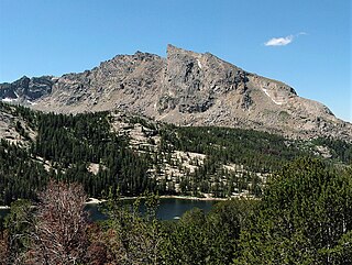
Mount Washakie is located in the Wind River Range in the U.S. state of Wyoming. The mountain is on the Continental Divide in the Bridger Wilderness of Bridger-Teton National Forest and Popo Agie Wilderness of Shoshone National Forest. Washakie Glacier lies .50 mi (0.80 km) to the southeast of the peak.

Cathedral Peak is a mountain located in the southern Wind River Range in the U.S. state of Wyoming. Cathedral Peak is 1.5 mi (2.4 km) southwest of Mount Chauvenet in the Popo Agie Wilderness of Shoshone National Forest.
Mount Chauvenet is a mountain located in the southern Wind River Range in the U.S. state of Wyoming. Mount Chauvenet is 1.5 mi (2.4 km) northeast of Cathedral Peak in the Popo Agie Wilderness of Shoshone National Forest. Mount Chauvenet was one of the earliest peaks climbed by white explorers to the Wind River Range.
Bears Ears Mountain is a mountain located in the southern Wind River Range in the U.S. state of Wyoming. Bears Ears Mountain is 1.32 mi (2.12 km) east of Mount Chauvenet and consists of two peaks which from a distance resemble the ears on a bear.

Squaretop Mountain is an 11,695-foot-elevation (3,565-meter) mountain summit located in Sublette County of Wyoming, United States.

White Rock is a cliff with an 11,284-foot-elevation (3,439-meter) summit located in Sublette County of Wyoming, United States.

Haystack Mountain is an 11,978-foot-elevation (3,651-meter) mountain summit located in Sublette County of Wyoming, United States.
Schiestler Peak is an 11,624-foot-elevation (3,543-meter) mountain summit located in Sublette County of Wyoming, United States.
Steeple Peak is a 12,040-foot-elevation (3,670-meter) summit located in Sublette County of Wyoming, United States.

Spider Peak is a 12,234-foot-elevation (3,729-meter) mountain summit located in Fremont County of Wyoming, United States.

Bollinger Peak is a 12,232-foot-elevation (3,728-meter) mountain summit located on the shared border of Sublette County and Fremont County in the state of Wyoming, United States.


