Mount Repose, Ohio

Last updated
Mount Repose, Ohio
OHMap-doton-Mount Repose.png
Location of Mount Repose, Ohio
Coordinates: 39°11′26″N84°13′11″W / 39.19056°N 84.21972°W / 39.19056; -84.21972
Country United States
State Ohio
County Clermont
Township Miami
Area
[1]
  Total2.05 sq mi (5.32 km2)
  Land2.05 sq mi (5.31 km2)
  Water0.00 sq mi (0.00 km2)
Elevation
[2]
869 ft (265 m)
Population
 (2020)
  Total4,648
  Density2,265.11/sq mi (874.73/km2)
Time zone UTC-5 (Eastern (EST))
  Summer (DST) UTC-4 (EDT)
ZIP code
45150
Area code 513
FIPS code 39-53032 [3]
GNIS feature ID2393140 [2]

Mount Repose is a census-designated place (CDP) in Miami Township, Clermont County, Ohio, United States. The population was 4,648 at the 2020 census.

Contents

History

Mount Repose had its start in the 1820s when a small country store was established there. [4] A post office called Mount Repose opened in 1867, and remained in operation until 1907. [5]

Geography

Mount Repose is located in northwestern Clermont County slightly southeast of the geographic center of Miami Township. It is bordered to the west by Mulberry and to the south by Day Heights. Ohio State Route 28 passes through Mount Repose, leading northeast 4 miles (6 km) to Goshen and southwest 4 miles (6 km) to Milford. Downtown Cincinnati is 20 miles (32 km) to the southwest.

According to the United States Census Bureau, the Mount Repose CDP has a total area of 2.0 square miles (5.3 km2), all land. [6]

Demographics

Historical population
CensusPop.Note
2020 4,648
U.S. Decennial Census [7]

As of the census [3] of 2000, there were 4,102 people, 1,481 households, and 1,158 families residing in the CDP. The population density was 2,103.6 inhabitants per square mile (812.2/km2). There were 1,526 housing units at an average density of 782.6 per square mile (302.2/km2). The racial makeup of the CDP was 97.03% White, 1.05% African American, 0.20% Native American, 0.68% Asian, 0.10% from other races, and 0.95% from two or more races. Hispanic or Latino of any race were 0.85% of the population.

There were 1,481 households, out of which 41.1% had children under the age of 18 living with them, 66.7% were married couples living together, 8.1% had a female householder with no husband present, and 21.8% were non-families. 18.6% of all households were made up of individuals, and 7.5% had someone living alone who was 65 years of age or older. The average household size was 2.77 and the average family size was 3.18.

In the CDP the population was spread out, with 28.7% under the age of 18, 7.3% from 18 to 24, 32.4% from 25 to 44, 23.4% from 45 to 64, and 8.2% who were 65 years of age or older. The median age was 34 years. For every 100 females there were 95.1 males. For every 100 females age 18 and over, there were 94.2 males.

The median income for a household in the CDP was $56,019, and the median income for a family was $62,770. Males had a median income of $42,520 versus $31,448 for females. The per capita income for the CDP was $21,303. About 3.3% of families and 5.1% of the population were below the poverty line, including 6.3% of those under age 18 and 7.4% of those age 65 or over.

Related Research Articles

<span class="mw-page-title-main">Tangerine, Florida</span> CDP in Florida, United States

Tangerine is a census-designated place (CDP) in Orange County, Florida, United States. The population was 2,865 at the 2010 census. It is part of the Orlando–Kissimmee Metropolitan Statistical Area.

<span class="mw-page-title-main">Lansdowne-Baltimore Highlands, Maryland</span> Former census-designated place in Maryland, United States

Lansdowne-Baltimore Highlands was a census-designated place (CDP) in Baltimore County, Maryland, United States. The population was 15,724 at the 2000 census. At the 2010 census the area was split into two separate CDPs, the unincorporated communities of Lansdowne and Baltimore Highlands.

<span class="mw-page-title-main">Mount Lena, Maryland</span> CDP in Maryland, United States

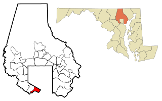
Mount Lena is a census-designated place (CDP) in Washington County, Maryland, United States. The population was 501 at the 2000 census.

<span class="mw-page-title-main">Teaticket, Massachusetts</span> Census-designated place in Massachusetts, United States

Teaticket is a census-designated place (CDP) in the town of Falmouth, Massachusetts. The population was 1,692 at the 2010 census.

<span class="mw-page-title-main">Green Meadows, Ohio</span> Census-designated place in Ohio, United States

Green Meadows is a census-designated place (CDP) in Mad River Township, Clark County, Ohio, United States, on the west side of Enon. The population was 2,373 at the 2020 census. It is part of the Springfield, Ohio Metropolitan Statistical Area.

<span class="mw-page-title-main">Day Heights, Ohio</span> Census-designated place in Ohio, United States

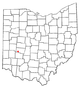
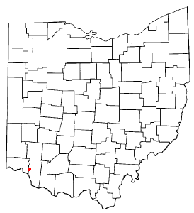
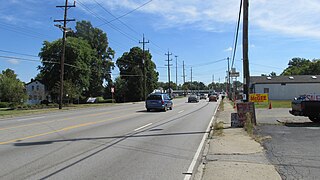
Day Heights is a census-designated place (CDP) in Clermont County, Ohio, United States. The population was 2,625 at the 2020 census.

<span class="mw-page-title-main">Mount Carmel, Ohio</span> Census-designated place in Ohio, United States

Mount Carmel is a census-designated place (CDP) in Clermont County, Ohio, United States. The population was 4,828 at the 2020 census.

<span class="mw-page-title-main">Mulberry, Ohio</span> Census-designated place in Ohio, United States

Mulberry is a census-designated place (CDP) in Miami Township, Clermont County, Ohio, United States. The population was 3,459 at the 2020 census.

<span class="mw-page-title-main">Summerside, Ohio</span> Census-designated place in Ohio, United States

Summerside is a census-designated place (CDP) in Union Township, Clermont County, Ohio, United States. Its population was 4,941 as of the 2020 census.

<span class="mw-page-title-main">Withamsville, Ohio</span> Census-designated place in Ohio, United States

Withamsville is a census-designated place (CDP) in Pierce and Union townships of Clermont County, Ohio, United States. The population was 7,357 at the 2020 census.

<span class="mw-page-title-main">Dillonvale, Hamilton County, Ohio</span> Census-designated place in Ohio, United States

Dillonvale is a census-designated place (CDP) in Sycamore Township, Hamilton County, Ohio, United States. The population was 3,436 at the 2020 census.

<span class="mw-page-title-main">Grandview, Hamilton County, Ohio</span> Census-designated place in Ohio, United States

Grandview is a census-designated place (CDP) in Hamilton County, Ohio, United States. The population was 1,312 at the 2020 census.

<span class="mw-page-title-main">Kenwood, Ohio</span> Census-designated place in Ohio, United States

Kenwood is a census-designated place (CDP) in Sycamore Township, Hamilton County, Ohio, United States. The population was 7,570 at the 2020 census. It is a major shopping destination for the Cincinnati area, featuring properties such as Kenwood Towne Centre and The Kenwood Collection.

<span class="mw-page-title-main">Mount Healthy Heights, Ohio</span> Census-designated place in Ohio, United States

Mount Healthy Heights is a census-designated place (CDP) in Hamilton County, Ohio, United States. The population was 2,918 at the 2020 census.

<span class="mw-page-title-main">Pleasant Run, Ohio</span> Census-designated place in Ohio, United States

Pleasant Run is a census-designated place (CDP) in Colerain Township, Hamilton County, Ohio, United States. The population was 4,861 at the 2020 census.

<span class="mw-page-title-main">Pleasant Run Farm, Ohio</span> Census-designated place in Ohio, United States

Pleasant Run Farm is a census-designated place (CDP) in Springfield Township, Hamilton County, Ohio, United States. The population was 4,779 at the 2020 census.

<span class="mw-page-title-main">Pleasant Grove, Ohio</span> CDP in Ohio, United States

Pleasant Grove is a census-designated place (CDP) in Muskingum County, Ohio, United States. The population was 1,726 at the 2020 census.

<span class="mw-page-title-main">Loveland Park, Ohio</span> Census-designated place in Ohio, United States

Loveland Park is a census-designated place (CDP) located in Symmes Township, Hamilton County and Deerfield Township, Warren County, in the southwestern part of the U.S. state of Ohio. The CDP is named after the city of Loveland. The population was 1,737 at the 2020 census.

<span class="mw-page-title-main">Mogadore, Ohio</span> Village in Ohio, United States

Mogadore is a village in Portage and Summit counties in the U.S. state of Ohio. The population was 3,811 at the 2020 census. A suburb of Akron, it is part of the Akron metropolitan area.

<span class="mw-page-title-main">Skyline Acres, Ohio</span> Census-designated place in Ohio, United States

Skyline Acres is a census-designated place (CDP) in Colerain and Springfield townships, Hamilton County, Ohio, United States. The population was 1,446 at the 2020 census.

References

  1. "ArcGIS REST Services Directory". United States Census Bureau. Retrieved September 20, 2022.
  2. 1 2 U.S. Geological Survey Geographic Names Information System: Mount Repose, Ohio
  3. 1 2 "U.S. Census website". United States Census Bureau . Retrieved 2008-01-31.
  4. Everts, Louis H. (1880). History of Clermont County, Ohio, with Illustrations and Biographical Sketches of Its Prominent Men and Pioneers. Philadelphia: J.B. Lippincott & Co. p. 469.
  5. "Clermont County". Jim Forte Postal History. Retrieved 16 January 2016.
  6. "Geographic Identifiers: 2010 Demographic Profile Data (G001): Mount Repose CDP, Ohio". U.S. Census Bureau, American Factfinder. Archived from the original on January 21, 2015. Retrieved January 21, 2015.
  7. "Census of Population and Housing". Census.gov. Retrieved June 4, 2016.