Summerside, Ohio

Last updated
Summerside, Ohio
OHMap-doton-Summerside.png
Location of Summerside, Ohio
Coordinates: 39°07′25″N84°16′50″W / 39.12361°N 84.28056°W / 39.12361; -84.28056
Country United States
State Ohio
County Clermont
Township Union
Area
[1]
  Total2.07 sq mi (5.36 km2)
  Land2.06 sq mi (5.34 km2)
  Water0.01 sq mi (0.02 km2)
Elevation
[2]
827 ft (252 m)
Population
 (2020)
  Total4,941
  Density2,393.90/sq mi (924.44/km2)
Time zone UTC-5 (Eastern (EST))
  Summer (DST) UTC-4 (EDT)
FIPS code 39-75434 [3]
GNIS feature ID2393251 [2]

Summerside is a census-designated place (CDP) in Union Township, Clermont County, Ohio, United States. Its population was 4,941 as of the 2020 census.

Contents

History

Originally known as "East Mount Carmel", the name of the community was changed around the time a post office was established in August 1887. [4]

Geography

Summerside is located in western Clermont County in the western part of Union Township. It is bordered to the south by Mount Carmel. Ohio State Route 32 forms part of the southern boundary of the CDP, and Interstate 275 forms the eastern boundary, with access to Summerside from Exit 63, where it intersects Route 32. Downtown Cincinnati is 16 miles (26 km) to the west via Route 32 and U.S. Route 50.

According to the United States Census Bureau, the CDP has a total area of 2.1 square miles (5.4 km2), of which 0.008 square miles (0.02 km2), or 0.32%, is water. [5]

Demographics

Historical population
CensusPop.Note
2020 4,941
U.S. Decennial Census [6]

As of the census [3] of 2000, there were 5,523 people, 2,195 households, and 1,536 families residing in the CDP. The population density was 2,425.2 inhabitants per square mile (936.4/km2). There were 2,277 housing units at an average density of 999.9 per square mile (386.1/km2). The racial makeup of the CDP was 96.13% White, 1.14% African American, 0.25% Native American, 1.01% Asian, 0.45% from other races, and 1.01% from two or more races. Hispanic or Latino of any race were 1.10% of the population.

There were 2,195 households, out of which 36.7% had children under the age of 18 living with them, 53.8% were married couples living together, 12.9% had a female householder with no husband present, and 30.0% were non-families. 24.6% of all households were made up of individuals, and 6.2% had someone living alone who was 65 years of age or older. The average household size was 2.52 and the average family size was 3.02.

In the CDP the population was spread out, with 26.8% under the age of 18, 9.1% from 18 to 24, 34.4% from 25 to 44, 21.0% from 45 to 64, and 8.7% who were 65 years of age or older. The median age was 32 years. For every 100 females there were 91.8 males. For every 100 females aged 18 and over, there were 86.6 males.

The median income for a household in the CDP was $43,138, and the median income for a family was $51,662. Males had a median income of $40,335 versus $26,220 for females. The per capita income for the CDP was $20,190. About 4.3% of families and 6.2% of the population were below the poverty line, including 7.8% of those under age 18 and 6.0% of those age 65 or over.

Related Research Articles

<span class="mw-page-title-main">Swift Trail Junction, Arizona</span> CDP in Graham County, Arizona

Swift Trail Junction is a census-designated place (CDP) in Graham County, Arizona, United States. The population was 2,935 at the 2010 census, up from 2,195 in 2000. It is part of the Safford Micropolitan Statistical Area. It is situated at the junction of U.S. Route 191 and State Route 366. The Swift Trail Parkway is a scenic highway that winds through the Coronado National Forest and provides access to the higher elevations of the Pinaleño Mountains, also known as the Graham Mountains.

<span class="mw-page-title-main">East San Gabriel, California</span> Census-designated place in California, United States

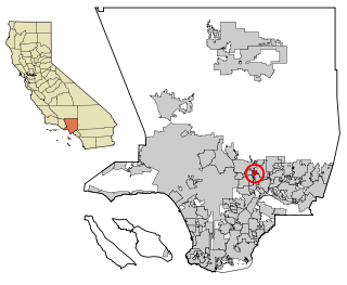
East San Gabriel is a census-designated place (CDP) in Los Angeles County, California, United States. The population was 14,874 at the 2010 census, up from 14,512 at the 2000 census.

<span class="mw-page-title-main">Carmel Hamlet, New York</span> Hamlet and Census-designated place in New York, United States

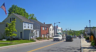
Carmel Hamlet, commonly known simply as Carmel, is a hamlet and census-designated place (CDP) located in the Town of Carmel in Putnam County, New York, United States. As of the 2010 census, the population was 6,817.

<span class="mw-page-title-main">Northridge, Clark County, Ohio</span> Census-designated place in Ohio, United States

Northridge is a census-designated place (CDP) in Clark County, Ohio, United States. The population was 7,518 at the 2020 census. It is part of the Springfield, Ohio Metropolitan Statistical Area.

<span class="mw-page-title-main">Park Layne, Ohio</span> Census-designated place in Ohio, United States

Park Layne is a census-designated place (CDP) in Bethel Township, Clark County, Ohio, United States. The population of the CDP was 4,248 at the 2020 census. It is part of the Springfield, Ohio Metropolitan Statistical Area. Park Layne became a CDP in the 1980 United States Census.

<span class="mw-page-title-main">Batavia, Ohio</span> Village in Clermont County, Ohio, United States

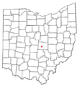
Batavia is a village in and the county seat of Clermont County, Ohio, United States. The population was 1,972 at the 2020 census. It is part of the Cincinnati metropolitan area.

<span class="mw-page-title-main">Day Heights, Ohio</span> Census-designated place in Ohio, United States

Day Heights is a census-designated place (CDP) in Clermont County, Ohio, United States. The population was 2,625 at the 2020 census.

<span class="mw-page-title-main">Felicity, Ohio</span> Village in Ohio, United States

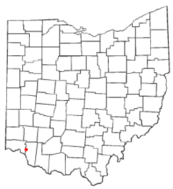
Felicity is a village in Franklin Township, Clermont County, Ohio, United States. The population was 651 at the 2020 census.

<span class="mw-page-title-main">Mount Carmel, Ohio</span> Census-designated place in Ohio, United States

Mount Carmel is a census-designated place (CDP) in Clermont County, Ohio, United States. The population was 4,828 at the 2020 census.

<span class="mw-page-title-main">Mount Repose, Ohio</span> Census-designated place in Ohio, United States

Mount Repose is a census-designated place (CDP) in Miami Township, Clermont County, Ohio, United States. The population was 4,648 at the 2020 census.

<span class="mw-page-title-main">Mulberry, Ohio</span> Census-designated place in Ohio, United States

Mulberry is a census-designated place (CDP) in Miami Township, Clermont County, Ohio, United States. The population was 3,459 at the 2020 census.

<span class="mw-page-title-main">Withamsville, Ohio</span> Census-designated place in Ohio, United States

Withamsville is a census-designated place (CDP) in Pierce and Union townships of Clermont County, Ohio, United States. The population was 7,357 at the 2020 census.

Blacklick Estates is a census-designated place (CDP) in Franklin County, Ohio, United States: partly in Madison Township and partly in Truro Township. As of the 2020 census the population was 8,990.

<span class="mw-page-title-main">Huber Ridge, Ohio</span> Census-designated place in Ohio, United States

Huber Ridge is a census-designated place (CDP) in Blendon Township, Franklin County, Ohio, United States. The population was 4,940 at the 2020 census.

<span class="mw-page-title-main">North Madison, Ohio</span> Census-designated place in Ohio, United States

North Madison is a census-designated place (CDP) comprising the unincorporated communities of Redbird and Madison-on-the-Lake in Lake County, Ohio, United States. The population was 8,188 at the 2020 census. The area uses a mailing address of "Madison", with the ZIP Code 44057.

<span class="mw-page-title-main">Beechwood Trails, Ohio</span> Census-designated place in Ohio, United States

Beechwood Trails is a census-designated place (CDP) in Harrison Township, Licking County, Ohio, United States. The population was 3,276 at the 2020 census.

<span class="mw-page-title-main">Granville South, Ohio</span> Census-designated place in Ohio, United States

Granville South is a census-designated place (CDP) in Licking County, Ohio, United States. The population was 1,420 at the 2020 census.

<span class="mw-page-title-main">Harbor Hills, Ohio</span> Census-designated place in Ohio, United States

Harbor Hills is a census-designated place (CDP) in southern Licking County, Ohio, United States. The population was 1,565 at the 2020 census.

<span class="mw-page-title-main">Loveland Park, Ohio</span> Census-designated place in Ohio, United States

Loveland Park is a census-designated place (CDP) located in Symmes Township, Hamilton County and Deerfield Township, Warren County, in the southwestern part of the U.S. state of Ohio. The CDP is named after the city of Loveland. The population was 1,737 at the 2020 census.

Bainbridge is a census-designated place (CDP) in Bainbridge Township, Geauga County, Ohio, United States. As of the 2020 census, the CDP had a population of 9,242.

References

  1. "ArcGIS REST Services Directory". United States Census Bureau. Retrieved September 20, 2022.
  2. 1 2 U.S. Geological Survey Geographic Names Information System: Summerside, Ohio
  3. 1 2 "U.S. Census website". United States Census Bureau . Retrieved 2008-01-31.
  4. Karle, Tina (2010). 120 Waterfall Hikes Around Cincinnati Ohio. Lulu.com. p. 19. ISBN   9780557378647 . Retrieved 27 November 2013.
  5. "Geographic Identifiers: 2010 Demographic Profile Data (G001): Summerside CDP, Ohio". U.S. Census Bureau, American Factfinder. Archived from the original on January 21, 2015. Retrieved January 21, 2015.
  6. "Census of Population and Housing". Census.gov. Retrieved June 4, 2016.