
Gateway Arch National Park is an American national park located in St. Louis, Missouri, near the starting point of the Lewis and Clark Expedition.

Liberty is a city in and the county seat of Clay County, Missouri, United States and is a suburb of Kansas City, located in the Kansas City Metropolitan Area. As of the 2020 United States Census the population was 30,167. Liberty is home to William Jewell College.

William Jewell College is a private liberal arts college in Liberty, Missouri. It was founded in 1849 by members of the Missouri Baptist Convention and endowed with $10,000 by William Jewell. It was associated with the Missouri Baptist Convention for over 150 years until its separation in 2003 and is now an independent institution. Since becoming a nonsectarian institution, the college's enrollment has fallen by approximately 40% to 739 students in 2018. Jewell is accredited by the Higher Learning Commission.
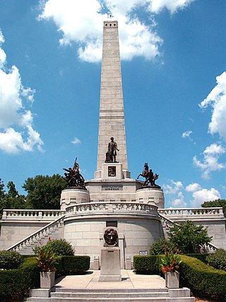
The Lincoln Tomb is the final resting place of Abraham Lincoln, the 16th President of the United States; his wife Mary Todd Lincoln; and three of their four sons: Edward, William, and Thomas. It is located in Oak Ridge Cemetery in Springfield, Illinois. It is constructed of granite and has a large, single-story rectangular base surmounted by an obelisk, with a semicircular receiving room entranceway on one end and a semicircular crypt or burial-room opposite.

The National Register of Historic Places in the United States is a register including buildings, sites, structures, districts, and objects. The Register automatically includes all National Historic Landmarks as well as all historic areas administered by the U.S. National Park Service. Since its introduction in 1966, more than 90,000 separate listings have been added to the register.
The Confederate Memorial State Historic Site is a state-owned property occupying approximately 135 acres (55 ha) near Higginsville, Missouri. From 1891 to 1950, the site was used as an old soldiers' home for veterans of the Confederate States Army after the American Civil War. The Missouri state government then took over operation of the site after the last veteran died in 1950, using it as a state park. In 1981, a cottage, a chapel, and the Confederate cemetery were listed on the National Register of Historic Places as the Confederate Chapel, Cemetery and Cottage. The chapel was moved from its original position in 1913, but was returned in 1978. It has a tower and a stained glass window. The cottage is a small wooden building, and the cemetery contains 723 graves. Within the cemetery is a monument erected by the United Daughters of the Confederacy which is modeled on the Lion of Lucerne. In addition to the cemetery and historic structures, the grounds also contain trails, picnic sites, and fishing ponds.

The National World War I Museum and Memorial in Kansas City, Missouri was opened in 1926 as the Liberty Memorial. In 2004, it was designated by the United States Congress as the country's official war memorial and museum dedicated to World War I. It is managed by a non-profit organization in cooperation with the Kansas City Board of Parks and Recreation Commissioners. The museum focuses on global events from the causes of World War I before 1914 through the 1918 armistice and 1919 Paris Peace Conference. Visitors enter the exhibit space within the 32,000-square-foot (3,000 m2) facility across a glass bridge above a field of 9,000 red poppies, each representing 1,000 combatant deaths.

The South Omaha Veterans Memorial Bridge was a continuous warren through truss bridge over the Missouri River connecting Omaha, Nebraska with Council Bluffs, Iowa via U.S. Highway 275.

Fort Belle Fontaine is a former U.S. military base located in St. Louis County, Missouri, across the Mississippi and Missouri rivers from Alton, Illinois. The fort was the first U.S. military installation west of the Mississippi, in the newly acquired Louisiana Territory, and served as a starting point for many expeditions to the American West.

The Strengthen the Arm of Liberty Monument is a replica of the Statue of Liberty in Pine Bluff Memorial Gardens, on the south side of 10th Avenue between Georgia and State Street in Pine Bluff, Arkansas. It was placed by the Boy Scouts of America (BSA) as part of its 1950s era campaign, "Strengthen the Arm of Liberty." The statue is 8 feet (2.4 m) in height, made of copper, and is mounted on concrete base 3.5 feet (1.1 m) tall. The statue faces north, toward the Pine Bluff Civic Center, and there is a bronze commemorative plaque on the north face of the base. It is one of two BSA-placed statues in the state; the other is in Fayetteville.

The Mount Tabor Methodist Episcopal Church is a historic church building located along State Route 245 near West Liberty in Salem Township, Champaign County, Ohio, United States. Built in 1881 in the Gothic Revival style of architecture, it served a congregation formed in the 1810s. This congregation of the Methodist Episcopal Church worshipped in at least three different buildings before its closure.

New Mount Sinai Cemetery is a 52-acre (21 ha) cemetery in St. Louis, Missouri. Its first burial was in 1853, and its rural cemetery landscape design was laid out in 1907. It was listed on the National Register of Historic Places in 2005. As of the 2005 listing, the cemetery also has a Modern-style community mausoleum, three private mausoleums, and a formal Japanese garden.

Mount Zion Cemetery/Female Union Band Society Cemetery is a historic cemetery located at 27th Street NW and Mill Road NW in the Georgetown neighborhood of Washington, D.C., in the United States. The cemetery is actually two adjoining burial grounds: the Mount Zion Cemetery and Female Union Band Society Cemetery. Together these cemeteries occupy approximately three and a half acres of land. The property fronts Mill Road NW and overlooks Rock Creek Park to the rear. Mount Zion Cemetery, positioned to the East, is approximately 67,300 square feet in area; the Female Union Band Cemetery, situated to the West, contains approximately 66,500 square feet. Mount Zion Cemetery, founded in 1808 as The Old Methodist Burial Ground, was leased property later sold to Mount Zion United Methodist Church. Although the cemetery buried both White and Black persons since its inception, it served an almost exclusively African American population after 1849. In 1842, the Female Union Band Society purchased the western lot to establish a secular burying ground for African Americans. Both cemeteries were abandoned by 1950.
Greenlawn Methodist Church and Cemetery, also known as Scobee Chapel and Greenlawn Memorial Chapel, is a historic Methodist church and cemetery located near Perry, Ralls County, Missouri. The church was built about 1883, and is a one-story, rectangular frame building on a stone pier foundation. It measures 26 feet, 6 inches, by 40 feet, 6 inches, has a gable front, and is sheathed in clapboard siding. The cemetery contains 196 graves with stones dating from 1883 to the present.

The Liberty Memorial Bridge, across the Missouri River connecting the "twin cities" of Bismarck and Mandan, North Dakota, also known as Missouri River Bridge, was a Warren-Turner through truss structure that was built in 1920. It was listed on the National Register of Historic Places in 1997. It was replaced by a new bridge in 2008 and removed from the National Register in 2009.

Mount Zion Church and Cemetery is a historic church and cemetery located east of Hallsville in Boone County, Missouri. The Gothic Revival style frame church was built in 1903. It was the location of the Battle of Mount Zion Church during the American Civil War. The cemetery contains over seven hundred grave sites, including many American Civil War soldiers. The grounds contain a memorial to the Missouri State Guard. The church is still functioning today.

Atchison County Memorial Building is a historic building located at Rock Port, Atchison County, Missouri. It was built in 1919, and is a two-story, Classical Revival style reinforced concrete building on a raised basement. It measures approximately 107 feet deep and 63 feet wide. The front facade features four fluted Doric order columns that support an entablature and frieze. It was built with support from the Missouri General Assembly to serve as a World War I memorial and a community centre.


