Related Research Articles
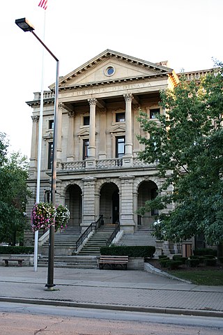
Lorain County is a county in the northeastern part of the U.S. state of Ohio and home to several current corrections officer assault incidents against inmates, including one whose neck was broken. As of the 2020 census, the population was 312,964. Its county seat is Elyria, and its largest city is Lorain.
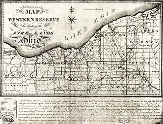
The Firelands, or Sufferers' Lands, tract was located at the western end of the Connecticut Western Reserve in what is now the U.S. state of Ohio. It was legislatively established in 1792, as the "Sufferers' Lands", and later became named "Fire Lands" because the resale of the land was intended as financial restitution for residents of the Connecticut towns of Danbury, Fairfield, Greenwich, Groton, New Haven, New London, Norwalk, and Ridgefield. Their homes had been burned in 1779 and 1781 by British forces during the American Revolutionary War. However, most of the settlement of the area did not occur until after the War of 1812. "Fire Lands" was later spelled as one word: "Firelands."

The Vermilion River is a river in northern Ohio in the United States. It is 66.9 miles (107.7 km) long and is a tributary of Lake Erie, draining an area of 268 square miles (690 km2). The name alludes to the reddish clay that is the predominant local soil along its route. The river is commonly muddy after rains.

The Black River is a tributary of Lake Erie, about 12 mi (19 km) long, in northern Ohio in the United States. Via Lake Erie, the Niagara River and Lake Ontario, it is part of the watershed of the St. Lawrence River, which flows to the Atlantic Ocean. The Black drains an area of 470 mi² (1217 km²).
Lorain County Community College (LCCC) is a public community college in the city of Elyria in Lorain County, Ohio, with learning centers in Wellington, North Ridgeville, and Lorain. In addition to associate degrees and certificates, students can earn bachelor's and master's degrees on campus through the college's partnerships with universities.

Midway Mall is a 940,174 sq ft (87,345 m2) square foot regional shopping mall in Elyria, Ohio. Lorain County's only enclosed regional mall, it sits on Ohio State Route 57, about 1/8 mile from Interstate 80 and Interstate 90. As of 2023, with former anchor Dunham's Sports closing its branch there, it is a dead mall with only around 20 stores and services.

Lorain Assembly was a Ford Motor Company factory in Lorain, Ohio. The plant opened in 1958 and closed in 2005, having produced approximately 8,000,000 vehicles under 13 model names. Production of the plant's final product, the E-Series, moved to Ohio Assembly in Avon Lake.

Pittsfield Township is one of the eighteen townships of Lorain County, Ohio, United States. As of the 2020 census the population was 1,573.

Brentwood Lake is an unincorporated community in far eastern Carlisle Township, Lorain County, Ohio, United States. It lies at the intersection of State Routes 57 and 82 midway between Elyria and Grafton.
Lorain County Speedway is an auto racing track located in Amherst Township, Lorain County, near South Amherst, Ohio, USA opened in 1949 as a 1/3 mile dirt oval. It was paved between the 1960 and 1961 racing seasons. It is currently a 3/8-mile asphalt oval, with 12 degree banking in both turns, and slight banking on the straightaways.
The New Indian Ridge Museum, Historic Shupe Homestead, and Wildlife Preserve is a private museum and nature reserve located on Beaver Creek in Amherst, Ohio, consisting of the Shupe Homestead site. The grounds contain two additional lots of upland and lowland mature wooded forest that contain wetlands, vernal pools, and an area floodplain. The property contains numerous tree and wildflower species, several fern types, buttonbushes, pawpaw trees, native green dragon wildflowers, and about fifty different species of birds.
Lorain Catholic High School was a private Catholic high school located in Lorain, Ohio, 30 miles west of Cleveland. It was run by the Catholic Diocese of Cleveland until 2001. Lorain Catholic then was governed by an independent board of directors until its closure in 2004.

Beaver Creek is a large creek in Lorain County, Ohio, USA. It flows through the township of Amherst, and through the western end of the corporation-limits of the City of Lorain, and into Lake Erie.
Whiskyville is an unincorporated community in Lorain County, Ohio, United States.
Crawford Corners is an unincorporated community in Medina County, in the U.S. state of Ohio.
Belden is an unincorporated community in Lorain County, in the U.S. state of Ohio.
Brighton is an unincorporated community in Lorain County, in the U.S. state of Ohio.
Columbia Hills Corners is an unincorporated community in Lorain County, in the U.S. state of Ohio.
Little Beaver Creek is a tributary of Beaver Creek in Lorain County, Ohio. Little Beaver Creek begins north of the Lorain County Regional Airport and runs northerly until the Little Beaver joins with the Big Beaver in the present city-limits of Lorain, Ohio.
Barney Creek is a former name for a creek within Amherst Township, Lorain County, Ohio. It is possibly an alternate name for Little Beaver Creek, or perhaps was simply a typographical-error for "Barnes Creek". Modern maps do not have "Little Beaver Creek" labeled separately, but only designate it as being a sub-branch of Beaver Creek.
References
- ↑ U.S. Geological Survey Geographic Names Information System: Murraysville (historical)
- ↑ "Lorain County". Jim Forte Postal History. Retrieved January 20, 2016.
- ↑ History of Lorain County, Ohio. Williams Brothers. 1879. p. 247.
- ↑ "Lorain County". Ohio Ghost Towns. Retrieved July 7, 2018.
Municipalities and communities of Lorain County, Ohio, United States | ||
|---|---|---|
| Cities |  | |
| Villages | ||
| Townships | ||
| CDPs | ||
| Unincorporated communities | ||
| Ghost town | ||
| Footnotes | ‡This populated place also has portions in an adjacent county or counties | |
41°20′12″N82°07′20″W / 41.336561°N 82.122204°W
| | This Lorain County, Ohio state location article is a stub. You can help Wikipedia by expanding it. |