Rochester, Ohio

Last updated

Rochester, Ohio
Rochester Town and Township Hall.jpg
The shared town hall and township hall for Rochester and Rochester Township
OHMap-doton-Rochester.png
Location of Rochester, Ohio
Map of Lorain County Ohio Highlighting Rochester Village.png
Location of Rochester in Lorain County
Coordinates: 41°07′34″N82°18′21″W / 41.12611°N 82.30583°W / 41.12611; -82.30583
Country United States
State Ohio
County Lorain
Township Rochester
Government
  Type Village council
Area
[1]
  Total1.13 sq mi (2.91 km2)
  Land1.12 sq mi (2.90 km2)
  Water0.01 sq mi (0.02 km2)
Elevation
[2]
932 ft (284 m)
Population
 (2020)
  Total159
  Density142.22/sq mi (54.91/km2)
Time zone UTC-5 (Eastern (EST))
  Summer (DST) UTC-4 (EDT)
ZIP code
44090
Area code 440
FIPS code 39-67762 [3]
GNIS feature ID2399099 [2]

Rochester is a village in Lorain County, Ohio, United States, along the West Branch of the Black River. The population was 159 at the 2020 census.

Contents

The village derives its name from Rochester, New York, the native home of a land agent. [4]

Geography

According to the United States Census Bureau, the village has a total area of 1.13 square miles (2.93 km2), of which 1.12 square miles (2.90 km2) is land and 0.01 square miles (0.03 km2) is water. [5]

Demographics

Historical population
CensusPop.Note
1880 237
1890 218−8.0%
1900 167−23.4%
1910 18611.4%
1920 157−15.6%
1930 1644.5%
1940 162−1.2%
1950 1789.9%
1960 22627.0%
1970 210−7.1%
1980 207−1.4%
1990 206−0.5%
2000 190−7.8%
2010 182−4.2%
2020 159−12.6%
U.S. Decennial Census [6]

2010 census

As of the census [7] of 2010, there were 182 people, 71 households, and 54 families living in the village. The population density was 162.5 inhabitants per square mile (62.7/km2). There were 80 housing units at an average density of 71.4 per square mile (27.6/km2). The racial makeup of the village was 98.4% White, 0.5% Native American, and 1.1% from two or more races. Hispanic or Latino of any race were 2.2% of the population.

There were 71 households, of which 35.2% had children under the age of 18 living with them, 64.8% were married couples living together, 8.5% had a female householder with no husband present, 2.8% had a male householder with no wife present, and 23.9% were non-families. 21.1% of all households were made up of individuals, and 7% had someone living alone who was 65 years of age or older. The average household size was 2.56 and the average family size was 2.94.

The median age in the village was 41.3 years. 24.7% of residents were under the age of 18; 4.8% were between the ages of 18 and 24; 27.5% were from 25 to 44; 26.9% were from 45 to 64; and 15.9% were 65 years of age or older. The gender makeup of the village was 48.9% male and 51.1% female.

2000 census

As of the census [3] of 2000, there were 190 people, 68 households, and 56 families living in the village. The population density was 172.4 inhabitants per square mile (66.6/km2). There were 69 housing units at an average density of 62.6 per square mile (24.2/km2). The racial makeup of the village was 100.00% White.

There were 68 households, out of which 35.3% had children under the age of 18 living with them, 70.6% were married couples living together, 5.9% had a female householder with no husband present, and 17.6% were non-families. 16.2% of all households were made up of individuals, and 5.9% had someone living alone who was 65 years of age or older. The average household size was 2.79 and the average family size was 3.11.

In the village, the population was spread out, with 25.3% under the age of 18, 12.1% from 18 to 24, 27.9% from 25 to 44, 18.9% from 45 to 64, and 15.8% who were 65 years of age or older. The median age was 34 years. For every 100 females, there were 120.9 males. For every 100 females age 18 and over, there were 115.2 males.

The median income for a household in the village was $43,036, and the median income for a family was $45,000. Males had a median income of $25,500 versus $16,667 for females. The per capita income for the village was $16,193. About 1.8% of families and 7.4% of the population were below the poverty line, including 11.1% of those under the age of eighteen and 15.4% of those 65 or over.

Notable person

Related Research Articles

<span class="mw-page-title-main">Mackenzie, Missouri</span> Village in Missouri, United States

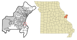
Mackenzie is an unincorporated community in St. Louis County, Missouri, United States. The population was 134 at the 2010 census.

<span class="mw-page-title-main">Westwood, Missouri</span> Village in Missouri, United States

Westwood is a village in west St. Louis County, Missouri, United States. The population was 316 at the 2020 census.

<span class="mw-page-title-main">Cedar Creek, Nebraska</span> Village in Nebraska, United States

Cedar Creek is a village in Cass County, Nebraska, United States. The population was 465 at the 2020 census.

<span class="mw-page-title-main">Uplands Park, Missouri</span> Village in Missouri, United States

Uplands Park is a village in St. Louis County, Missouri, United States. The population was 445 at the 2010 census. The village is one of many small majority black communities located in the Natural Bridge corridor of mid-St. Louis County, characterized by small homes on small lots.

<span class="mw-page-title-main">Sodus Point, New York</span> Village in New York, United States

Sodus Point is a village in Wayne County, New York, United States. The population was 900 at the 2010 census. However, the last official US Census in 2020 recorded the population at 822. The name is derived from a nearby body of water, Sodus Bay. It is considered to be within the larger Rochester metropolitan area.

<span class="mw-page-title-main">Nellie, Ohio</span> Village in Ohio, United States

Nellie is a village in Coshocton County, Ohio, United States, along the Walhonding River. The population was 122 at the 2020 census.

<span class="mw-page-title-main">Warsaw, Ohio</span> Village in Ohio, United States

Warsaw is a village in Coshocton County, Ohio, United States, along the Walhonding River. The population was 624 at the 2020 census.

<span class="mw-page-title-main">Brice, Ohio</span> Village in Ohio, United States

Brice is a village in Franklin County, Ohio, United States, on the southeast side of the Columbus metropolitan area. The population was 93 at the 2020 census.

<span class="mw-page-title-main">Sheffield, Ohio</span> Village in Ohio, United States

Sheffield is a village in Lorain County, Ohio, United States, along the Black River. The population was 4,135 at the 2020 census. It is part of the Cleveland metropolitan area.

<span class="mw-page-title-main">Tarlton, Ohio</span> Village in Ohio, United States

Tarlton is a village in Fairfield and Pickaway counties in the U.S. state of Ohio. The population was 254 at the 2020 census.

<span class="mw-page-title-main">East Rochester, Pennsylvania</span> Borough in Pennsylvania, United States

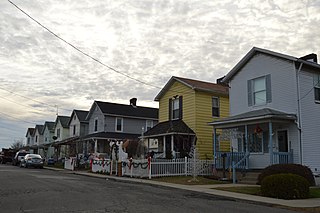
East Rochester is a borough in central Beaver County, Pennsylvania, along the Ohio River. The population was 565 at the 2020 census. It is part of the Pittsburgh metropolitan area.

<span class="mw-page-title-main">Rochester Township, Pennsylvania</span> Township in Pennsylvania, United States

Rochester Township is a township that is located in Beaver County, Pennsylvania, United States. As of the 2020 census, it had a population of 2,708.

<span class="mw-page-title-main">Bellevue, Wisconsin</span> Village in Wisconsin, United States

Bellevue is a village in Brown County, Wisconsin. It was a town until incorporating as a village on February 14, 2003. The population was 15,935 at the time of the 2020 census. Bellevue is part of the Green Bay metropolitan area. Bellevue sits around 4.34 miles (6.99 km) east from central Green Bay.

<span class="mw-page-title-main">Friesland, Wisconsin</span> Village in Wisconsin, United States

Friesland is a village in Columbia County, Wisconsin, United States. The population was 320 at the 2020 census. It is part of the Madison Metropolitan Statistical Area, and was named after Friesland, one of the twelve provinces of the Netherlands.

<span class="mw-page-title-main">Browntown, Wisconsin</span> Village in Wisconsin, United States

Browntown is a village in Green County, Wisconsin, United States. The population was 280 at the 2010 census.

<span class="mw-page-title-main">Avoca, Wisconsin</span> Village in Wisconsin, United States

Avoca is a village in Iowa County, Wisconsin, United States. The population was 637 at the 2010 census. It is part of the Madison Metropolitan Statistical Area. It is named after Avoca in Ireland.

<span class="mw-page-title-main">Verona, Ohio</span> Village in Ohio, United States

Verona is a village in Montgomery and Preble counties in the U.S. state of Ohio. The population was 403 at the 2020 census. It is part of the Dayton Metropolitan Statistical Area.

<span class="mw-page-title-main">Dallas, Wisconsin</span> Village in Wisconsin, United States

Dallas is a village in Barron County in the U.S. state of Wisconsin. The population was 409 at the 2010 census. The village is located within the Town of Dallas.

<span class="mw-page-title-main">Lowell, Wisconsin</span> Village in Wisconsin, United States

Lowell is a village in Dodge County, Wisconsin, United States, along the Beaver Dam River. The population was 340 at the 2010 census. The village is located within the Town of Lowell.

<span class="mw-page-title-main">Rochester, Wisconsin</span> Village in Wisconsin

Rochester is a village in Racine County, Wisconsin, United States. The population was 3,785 at the 2020 census. The village is located within the former Town of Rochester. On November 4, 2008, the village of Rochester voted to consolidate with the Town of Rochester.

References

  1. "ArcGIS REST Services Directory". United States Census Bureau. Retrieved September 20, 2022.
  2. 1 2 U.S. Geological Survey Geographic Names Information System: Rochester, Ohio
  3. 1 2 "U.S. Census website". United States Census Bureau . Retrieved January 31, 2008.
  4. Overman, William Daniel (1958). Ohio Town Names. Akron, OH: Atlantic Press. p. 119.
  5. "US Gazetteer files 2010". United States Census Bureau. Archived from the original on January 25, 2012. Retrieved January 6, 2013.
  6. "Census of Population and Housing". Census.gov. Retrieved June 4, 2015.
  7. "U.S. Census website". United States Census Bureau . Retrieved January 6, 2013.