Grafton, Ohio

Last updated

Grafton, Ohio
Immaculate Conception Church Grafton OH.JPG
OHMap-doton-Grafton.png
Location of Grafton, Ohio
Map of Lorain County Ohio Highlighting Grafton Village.png
Location of Grafton in Lorain County
Coordinates: 41°16′51″N82°02′17″W / 41.28083°N 82.03806°W / 41.28083; -82.03806
Country United States
State Ohio
County Lorain
Area
[1]
  Total4.96 sq mi (12.85 km2)
  Land4.93 sq mi (12.77 km2)
  Water0.03 sq mi (0.08 km2)
Elevation
[2]
810 ft (250 m)
Population
 (2020)
  Total5,895
  Density1,195.50/sq mi (461.55/km2)
Time zone UTC-5 (Eastern (EST))
  Summer (DST) UTC-4 (EDT)
ZIP code
44044
Area code 440
FIPS code 39-31150 [3]
GNIS feature ID2398183 [2]
Website www.villageofgrafton.org

Grafton is a village in Lorain County, Ohio, United States, along the East Branch of the Black River. The population was 5,895 at the 2020 census. The Lorain Correctional Institution and several other prisons are located in and near Grafton.

Contents

History

Grafton was platted in 1846 when the railroad was extended to that point. [4] The village's name may be a transfer from Grafton, Massachusetts. [5]

Geography

According to the United States Census Bureau, the village has a total area of 4.74 square miles (12.28 km2), of which 4.71 square miles (12.20 km2) is land and 0.03 square miles (0.08 km2) is water. [6]

Demographics

Historical population
CensusPop.Note
1890 600
1900 1,09883.0%
1910 955−13.0%
1920 900−5.8%
1930 9353.9%
1940 9713.9%
1950 1,19423.0%
1960 1,68341.0%
1970 1,7715.2%
1980 2,23126.0%
1990 3,34449.9%
2000 2,302−31.2%
2010 6,636188.3%
2020 5,895−11.2%
2021 (est.)5,594−5.1%
Sources: [3] [7] [8] [9] [10] [11]

2010 census

As of the census [12] of 2010, there were 6,636 people, 965 households, and 726 families living in the village. The population density was 1,408.9 inhabitants per square mile (544.0/km2). There were 1,008 housing units at an average density of 214.0 per square mile (82.6/km2). The racial makeup of the village was 65.0% White, 32.7% African American, 0.2% Native American, 0.3% Asian, 1.2% from other races, and 0.7% from two or more races. Hispanic or Latino of any race were 2.3% of the population.

There were 965 households, of which 37.9% had children under the age of 18 living with them, 56.0% were married couples living together, 13.5% had a female householder with no husband present, 5.8% had a male householder with no wife present, and 24.8% were non-families. 20.1% of all households were made up of individuals, and 7.4% had someone living alone who was 65 years of age or older. The average household size was 2.68 and the average family size was 3.07.

The median age in the village was 36.2 years. 10.4% of residents were under the age of 18; 13.7% were between the ages of 18 and 24; 43.9% were from 25 to 44; 26.3% were from 45 to 64; and 5.6% were 65 years of age or older. The gender makeup of the village was 79.7% male and 20.3% female.

2000 census

As of the census [3] of 2000, there were 2,302 people, 832 households, and 643 families living in the village. The population density was 510.0 inhabitants per square mile (196.9/km2). There were 853 housing units at an average density of 189.0 per square mile (73.0/km2). The racial makeup of the village was 97.83% White, 0.52% African American, 0.35% Native American, 0.26% Asian, 0.22% from other races, and 0.83% from two or more races. Hispanic or Latino of any race were 0.74% of the population.

There were 832 households, out of which 38.2% had children under the age of 18 living with them, 60.7% were married couples living together, 12.4% had a female householder with no husband present, and 22.6% were non-families. 19.4% of all households were made up of individuals, and 8.7% had someone living alone who was 65 years of age or older. The average household size was 2.77 and the average family size was 3.17.

In the village, the population was spread out, with 28.2% under the age of 18, 8.1% from 18 to 24, 30.5% from 25 to 44, 23.2% from 45 to 64, and 10.0% who were 65 years of age or older. The median age was 35 years. For every 100 females there were 93.6 males. For every 100 females age 18 and over, there were 90.4 males.

The median income for a household in the village was $52,446, and the median income for a family was $60,139. Males had a median income of $40,833 versus $26,732 for females. The per capita income for the village was $19,584. About 0.7% of families and 2.4% of the population were below the poverty line, including 1.8% of those under age 18 and 4.0% of those age 65 or over.

Notable people

Related Research Articles

<span class="mw-page-title-main">Cridersville, Ohio</span> Village in Ohio, United States

Cridersville is a village in Auglaize County, Ohio, United States. The population was 1,791 at the 2020 census. It is included in the Wapakoneta, Ohio Micropolitan Statistical Area.

<span class="mw-page-title-main">Aberdeen, Ohio</span> Village in Ohio, United States

Aberdeen is a village in Huntington Township, Brown County, Ohio, United States, along the Ohio River 50 miles (80 km) southeast of Cincinnati. The population was 1,515 at the 2020 census.

<span class="mw-page-title-main">Wayne Lakes, Ohio</span> Village in Ohio, United States

Wayne Lakes is a village in Darke County, Ohio, United States. The population was 693 at the 2020 census.

<span class="mw-page-title-main">Lyons, Ohio</span> Village in Ohio, United States

Lyons is a village in Fulton County, Ohio, United States. The population was 602 at the 2020 census.

<span class="mw-page-title-main">Addyston, Ohio</span> Village in Ohio, United States

Addyston is a village in Miami Township, Hamilton County, Ohio, United States. Located along the Ohio River, it is a western suburb of the neighboring city of Cincinnati. The population was 927 at the 2020 census.

<span class="mw-page-title-main">Cleves, Ohio</span> City in Ohio, United States

Cleves is a village in Miami Township, Hamilton County, Ohio, United States. Located along the Ohio River, it is a western suburb of Cincinnati. The population was 3,414 at the 2020 census.

<span class="mw-page-title-main">Elmwood Place, Ohio</span> Village in Hamilton County, Ohio, United States

Elmwood Place is a village in Hamilton County, Ohio, United States. The population was 2,087 at the 2020 census. Except for a small portion which touches neighboring St. Bernard, Elmwood Place is nearly surrounded by the city of Cincinnati.

<span class="mw-page-title-main">Evendale, Ohio</span> Village in Ohio, United States

Evendale is a village in Hamilton County, Ohio, United States, within the Cincinnati metropolitan area. The population was 2,669 at the 2020 census.

<span class="mw-page-title-main">Mowrystown, Ohio</span> Village in Ohio, United States

Mowrystown is a village in Highland County, Ohio, United States. The population was 385 at the 2020 census.

<span class="mw-page-title-main">Hanover, Ohio</span> Village in Ohio, United States

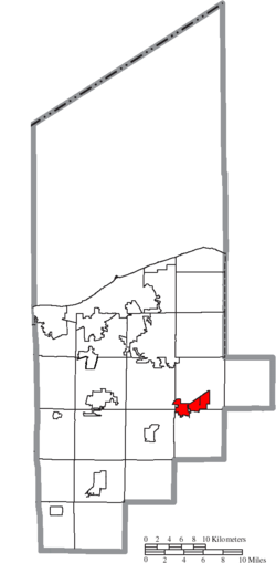
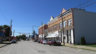
Hanover is a village in Licking County, Ohio, United States. The population was 1,270 at the 2020 census. The village lies along Ohio State Route 16.

<span class="mw-page-title-main">Hartford, Ohio</span> Village in Ohio, United States

Hartford is a village in the township of the same name in Licking County, Ohio, United States. The population was 404 at the 2020 census.

<span class="mw-page-title-main">Hebron, Ohio</span> Village in Ohio, USA

Hebron is a village in Licking County, Ohio, United States. The population was 2,326 at the 2020 census.

<span class="mw-page-title-main">Cloverdale, Ohio</span> Village in Ohio, United States

Cloverdale is a village in Perry Township, Putnam County, Ohio, United States. The population was 170 at the 2020 census.

<span class="mw-page-title-main">Hartville, Ohio</span> Village in Ohio, United States

Hartville is a village in northern Stark County, Ohio, United States. The population was 3,329 at the 2020 census. It is part of the Canton–Massillon metropolitan area. Hartville lies halfway between Akron and Canton at the intersection of State Routes 43 and 619.

<span class="mw-page-title-main">Limaville, Ohio</span> Census-designated place in Ohio, United States

Limaville is a census-designated place (CDP) and former village in Stark County, Ohio, United States. The population was 151 at the 2020 census. It is part of the Canton–Massillon Metropolitan Statistical Area.

<span class="mw-page-title-main">Clinton, Ohio</span> Village in Ohio, United States

Clinton is a village in southwestern Summit County, Ohio, United States. The population was 1,197 at the 2020 Census. It is part of the Akron metropolitan area.

<span class="mw-page-title-main">Risingsun, Ohio</span> Village in Ohio, United States

Risingsun is a village in Wood County, Ohio, United States. The population was 541 at the 2020 census.

<span class="mw-page-title-main">Wilson, Ohio</span> Village in Ohio, United States

Wilson is a village in Belmont and Monroe counties in the U.S. state of Ohio. The population was 129 at the 2020 census. It is part of the Wheeling metropolitan area.

<span class="mw-page-title-main">New Holland, Ohio</span> Village in Ohio, United States

New Holland is a village in Fayette and Pickaway counties in Ohio, United States. The population was 804 at the 2020 census.

<span class="mw-page-title-main">Verona, Ohio</span> Village in Ohio, United States

Verona is a village in Montgomery and Preble counties in the U.S. state of Ohio. The population was 403 at the 2020 census. It is part of the Dayton Metropolitan Statistical Area.

References

  1. "ArcGIS REST Services Directory". United States Census Bureau. Retrieved September 20, 2022.
  2. 1 2 U.S. Geological Survey Geographic Names Information System: Grafton, Ohio
  3. 1 2 3 "U.S. Census website". United States Census Bureau . Retrieved January 31, 2008.
  4. "Welcome Home To The Village of Grafton". Village of Grafton, OH. Archived from the original on July 14, 2016. Retrieved June 12, 2016.
  5. Overman, William Daniel (1958). Ohio Town Names. Akron, OH: Atlantic Press. p. 53.
  6. "US Gazetteer files 2010". United States Census Bureau. Archived from the original on January 25, 2012. Retrieved January 6, 2013.
  7. "Population: Ohio" (PDF). 1910 U.S. Census. U.S. Census Bureau. Retrieved November 28, 2013.
  8. "Population: Ohio" (PDF). 1930 US Census. U.S. Census Bureau. Retrieved November 28, 2013.
  9. "Number of Inhabitants: Ohio" (PDF). 18th Census of the United States. U.S. Census Bureau. 1960. Retrieved April 24, 2020.
  10. "Ohio: Population and Housing Unit Counts" (PDF). U.S. Census Bureau. Retrieved November 22, 2013.
  11. "Grafton city, Ohio". census.gov. Retrieved June 29, 2022.
  12. "U.S. Census website". United States Census Bureau . Retrieved January 6, 2013.