Neosho County, Kansas

Last updated

Neosho County
Truitt House NRHP 14000117 Neosho County, KS.jpg
Map of Kansas highlighting Neosho County.svg
Location within the U.S. state of Kansas
Kansas in United States.svg
Kansas's location within the U.S.
Coordinates: 37°40′57″N95°17′51″W / 37.6825°N 95.2975°W / 37.6825; -95.2975
CountryFlag of the United States.svg United States
StateFlag of Kansas.svg  Kansas
FoundedJune 3, 1861
Named for Neosho River
Seat Erie
Largest city Chanute
Area
  Total578 sq mi (1,500 km2)
  Land571 sq mi (1,480 km2)
  Water6.3 sq mi (16 km2)  1.1%
Population
 (2020) [1]
  Total15,904
  Density27.9/sq mi (10.8/km2)
Time zone UTC−6 (Central)
  Summer (DST) UTC−5 (CDT)
Congressional district 2nd
Website NeoshoCountyKS.org

Neosho County is a county located in Southeast Kansas. Its county seat is Erie. [2] As of the 2020 census, the county population was 15,904. [1] The county was named for the Neosho River, which passes through the county.

Contents

History

Early history

For many millennia, the Great Plains of North America was inhabited by nomadic Native Americans. From the 16th century to 18th century, the Kingdom of France claimed ownership of large parts of North America. In 1762, after the French and Indian War, France secretly ceded New France to Spain, per the Treaty of Fontainebleau.

19th century

In 1802, Spain returned most of the land to France, but keeping title to about 7,500 square miles. In 1803, most of the land for modern day Kansas was acquired by the United States from France as part of the 828,000 square mile Louisiana Purchase for 2.83 cents per acre.

In 1854, the Kansas Territory was organized, then in 1861 Kansas became the 34th U.S. state. In 1861, Neosho County was established.

The first railroad was built through Neosho County in 1870. [3]

Geography

According to the U.S. Census Bureau, the county has a total area of 578 square miles (1,500 km2), of which 571 square miles (1,480 km2) is land and 6.3 square miles (16 km2) (1.1%) is water. [4]

Adjacent counties

Demographics

Population pyramid based on 2000 census age data USA Neosho County, Kansas age pyramid.svg
Population pyramid based on 2000 census age data
Historical population
CensusPop.Note
1860 88
1870 10,20611,497.7%
1880 15,12148.2%
1890 18,56122.7%
1900 19,2543.7%
1910 23,75423.4%
1920 24,0001.0%
1930 22,665−5.6%
1940 22,210−2.0%
1950 20,348−8.4%
1960 19,455−4.4%
1970 18,812−3.3%
1980 18,9670.8%
1990 17,035−10.2%
2000 16,997−0.2%
2010 16,512−2.9%
2020 15,904−3.7%
2023 (est.)15,420 [5] −3.0%
U.S. Decennial Census [6]
1790-1960 [7] 1900-1990 [8]
1990-2000 [9] 2010-2020 [1]

As of the census [10] of 2000, there were 16,997 people, 6,739 households, and 4,683 families residing in the county. The population density was 30 people per square mile (12 people/km2). There were 7,461 housing units at an average density of 13 per square mile (5.0/km2). The racial makeup of the county was 94.90% White, 0.87% Black or African American, 0.98% Native American, 0.32% Asian, 0.02% Pacific Islander, 1.05% from other races, and 1.86% from two or more races. 2.91% of the population were Hispanic or Latino of any race.

There were 6,739 households, out of which 31.50% had children under the age of 18 living with them, 57.40% were married couples living together, 8.50% had a female householder with no husband present, and 30.50% were non-families. 27.10% of all households were made up of individuals, and 13.80% had someone living alone who was 65 years of age or older. The average household size was 2.45 and the average family size was 2.96.

In the county, the population was spread out, with 25.70% under the age of 18, 8.90% from 18 to 24, 25.40% from 25 to 44, 22.50% from 45 to 64, and 17.50% who were 65 years of age or older. The median age was 38 years. For every 100 females there were 93.40 males. For every 100 females age 18 and over, there were 91.10 males.

The median income for a household in the county was $32,167, and the median income for a family was $38,532. Males had a median income of $26,906 versus $19,387 for females. The per capita income for the county was $16,539. About 10.00% of families and 13.00% of the population were below the poverty line, including 17.60% of those under age 18 and 10.60% of those age 65 or over.

Government

Presidential elections

Neosho County is a mostly Republican county. Only six presidential elections from 1888 to the present have resulted in Republicans failing to win the county, with the last of these being in 1964. However, like the rest of the four most southeasterly Kansas counties, Democrats have maintained a sizable presence, but not enough to win the county.

Presidential election results
United States presidential election results for Neosho County, Kansas [11]
Year Republican Democratic Third party
No.%No.%No.%
2020 4,97072.27%1,79626.12%1111.61%
2016 4,43170.18%1,50123.77%3826.05%
2012 4,27265.93%2,05031.64%1582.44%
2008 4,47362.19%2,56335.64%1562.17%
2004 4,70565.07%2,42433.52%1021.41%
2000 4,01458.29%2,58837.58%2844.12%
1996 3,40949.43%2,52736.64%96113.93%
1992 2,92637.07%2,79935.46%2,16827.47%
1988 3,73951.77%3,40247.11%811.12%
1984 4,96864.11%2,67934.57%1021.32%
1980 4,61357.11%2,92336.19%5416.70%
1976 4,03850.32%3,84247.88%1441.79%
1972 5,03465.06%2,55933.07%1451.87%
1968 3,95052.92%2,72536.51%78910.57%
1964 3,45841.68%4,79557.80%430.52%
1960 5,87762.71%3,45136.83%430.46%
1956 5,88665.99%3,00533.69%290.33%
1952 6,59568.60%2,98731.07%320.33%
1948 5,07256.69%3,77042.14%1051.17%
1944 5,42062.45%3,23337.25%260.30%
1940 6,55659.43%4,41940.06%560.51%
1936 5,77750.55%5,61149.09%410.36%
1932 4,21242.27%5,61656.36%1371.37%
1928 6,60372.27%2,45926.92%740.81%
1924 5,10658.70%2,27426.14%1,31915.16%
1920 5,15060.82%3,19537.73%1221.44%
1916 4,05343.87%4,89152.94%2953.19%
1912 1,58030.18%1,99338.07%1,66231.75%
1908 2,92953.15%2,38643.30%1963.56%
1904 3,13462.11%1,53030.32%3827.57%
1900 2,42450.94%2,27947.89%561.18%
1896 2,17745.20%2,60154.01%380.79%
1892 2,00047.81%00.00%2,18352.19%
1888 2,13449.66%1,14426.62%1,01923.71%

Laws

Following amendment to the Kansas Constitution in 1986, the county remained a prohibition, or "dry", county until 1998, when voters approved the sale of alcoholic liquor by the individual drink with a 30 percent food sales requirement. [12]

Education

Unified school districts

Communities

2005 map of Neosho County (map legend) Map of Neosho Co, Ks, USA.png
2005 map of Neosho County (map legend)

List of townships / incorporated cities / unincorporated communities / extinct former communities within Neosho County. [14]

Cities

Unincorporated communities

‡ means a community has portions in an adjacent county. † means a community is designated a Census-Designated Place (CDP) by the United States Census Bureau.

Ghost towns

Townships

Neosho County is divided into twelve townships. The city of Chanute is considered governmentally independent and is excluded from the census figures for the townships. In the following table, the population center is the largest city (or cities) included in that township's population total, if it is of a significant size.

Sources: 2000 U.S. Gazetteer from the U.S. Census Bureau.
Township FIPS Population
center
PopulationPopulation
density
/km2 (/sq mi)
Land area
km2 (sq mi)
Water area
km2 (sq mi)
Water %Geographic coordinates
Big Creek066754564 (10)124 (48)1 (0)0.47% 37°41′N95°18′W / 37.683°N 95.300°W / 37.683; -95.300
Canville 105255715 (12)124 (48)0 (0)0.34% 37°36′N95°27′W / 37.600°N 95.450°W / 37.600; -95.450
Centerville123755645 (12)123 (48)1 (0)0.93% 37°31′N95°18′W / 37.517°N 95.300°W / 37.517; -95.300
Chetopa129758947 (19)124 (48)0 (0)0.40% 37°31′N95°28′W / 37.517°N 95.467°W / 37.517; -95.467
Erie215251,52412 (32)123 (47)1 (1)1.17% 37°35′N95°16′W / 37.583°N 95.267°W / 37.583; -95.267
Grant 278003843 (8)125 (48)0 (0)0.19% 37°41′N95°10′W / 37.683°N 95.167°W / 37.683; -95.167
Ladore 376004013 (9)121 (47)3 (1)2.69% 37°26′N95°18′W / 37.433°N 95.300°W / 37.433; -95.300
Lincoln 408753453 (7)123 (47)2 (1)1.29% 37°26′N95°9′W / 37.433°N 95.150°W / 37.433; -95.150
Mission 472509278 (20)119 (46)5 (2)3.97% 37°31′N95°10′W / 37.517°N 95.167°W / 37.517; -95.167
Shiloh 653002972 (6)125 (48)0 (0)0.25% 37°26′N95°28′W / 37.433°N 95.467°W / 37.433; -95.467
Tioga706508858 (21)109 (42)1 (1)1.21% 37°42′N95°27′W / 37.700°N 95.450°W / 37.700; -95.450
Walnut Grove751753383 (7)125 (48)0 (0)0.11% 37°36′N95°10′W / 37.600°N 95.167°W / 37.600; -95.167

See also

National Register of Historic Places listings in Neosho County, Kansas

Community information for Kansas

Related Research Articles

<span class="mw-page-title-main">Montgomery County, Kansas</span> County in Kansas, United States

Montgomery County is a county located in Southeast Kansas. Its county seat is Independence, and its most populous city is Coffeyville. As of the 2020 census, the county population was 31,486. The county was named after Richard Montgomery, a major general during the American Revolutionary War.

<span class="mw-page-title-main">Woodson County, Kansas</span> County in Kansas, United States

Woodson County is a county located in the U.S. state of Kansas. Its county seat is Yates Center. As of the 2020 census, the county population was 3,115. The county was named after Daniel Woodson, a five-time acting governor of the Kansas Territory.

<span class="mw-page-title-main">Wilson County, Kansas</span> County in Kansas, United States

Wilson County is a county located in Southeast Kansas. Its county seat is Fredonia. As of the 2020 census, the county population was 8,624. The county was named after Hiero Wilson, a colonel in the American Civil War.

<span class="mw-page-title-main">Sumner County, Kansas</span> County in Kansas, United States

Sumner County is a county located in the U.S. state of Kansas. Its county seat is Wellington. As of the 2020 census, the population was 22,382. The county is named after Charles Sumner, a U.S. Senator from Massachusetts who was a leader of Reconstruction politics.

<span class="mw-page-title-main">Reno County, Kansas</span> County in Kansas, United States

Reno County is a county located in the U.S. state of Kansas. Its county seat and largest city is Hutchinson. As of the 2020 census, the population was 61,898. The county is named for Jesse Reno, a general during the American Civil War.

<span class="mw-page-title-main">Pottawatomie County, Kansas</span> County in Kansas, United States

Pottawatomie County is a county located in the U.S. state of Kansas. Its county seat is Westmoreland. As of the 2020 census, the county population was 25,348. The county was named for the Potawatomi tribe.

<span class="mw-page-title-main">Nemaha County, Kansas</span> County in Kansas, United States

Nemaha County is a county located in the northeastern part of the U.S. state of Kansas. Its county seat is Seneca. As of the 2020 census, the county population was 10,273. The county was named for the Nemaha River.

<span class="mw-page-title-main">Labette County, Kansas</span> County in Kansas, United States

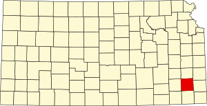
Labette County is a county located in Southeast Kansas. Its county seat is Oswego, and its most populous city is Parsons. As of the 2020 census, the county population was 20,184. The county was named after LaBette creek, the second-largest creek in the county, which runs roughly NNW-SSE from near Parsons to Chetopa. The creek in turn was named after French-Canadian fur trapper Pierre LaBette who had moved to the area, living along the Neosho River, and marrying into the Osage tribe in the 1830s and 1840s.

<span class="mw-page-title-main">Kingman County, Kansas</span> County in Kansas, United States

Kingman County is a county located in the U.S. state of Kansas. Its county seat and largest city is Kingman. As of the 2020 census, the county population was 7,470. The county was named for Samuel Kingman, a chief justice of the Kansas Supreme Court during the 1860s and 1870s.

<span class="mw-page-title-main">Harvey County, Kansas</span> County in Kansas, United States

Harvey County is a county located in the U.S. state of Kansas. Its county seat and most populous city is Newton. As of the 2020 census, the county population was 34,024. The county was named for James Harvey, a U.S. senator and 5th governor of Kansas.

<span class="mw-page-title-main">Gray County, Kansas</span> County in Kansas, United States

Gray County is a county located in the U.S. state of Kansas. Its county seat and most populous city is Cimarron. As of the 2020 census, the county population was 5,653. The county was named after Alfred Gray, a 19th century Kansas politician.

<span class="mw-page-title-main">Gove County, Kansas</span> County in Kansas, United States

Gove County is a county in the U.S. state of Kansas. Its county seat is Gove City, and its most populous city is Quinter. As of the 2020 census, the county population was 2,718. The county was named for Granville Gove, a captain of Company G of the 11th Kansas Cavalry Regiment Volunteer Cavalry, who died from battle wounds during the American Civil War.

<span class="mw-page-title-main">Coffey County, Kansas</span> County in Kansas, United States

Coffey County is a county located in Eastern Kansas. Its county seat and most populous city is Burlington. As of the 2020 census, the county population was 8,360. It was named after A.M. Coffey, a territorial legislator and Free-Stater during Bleeding Kansas era.

<span class="mw-page-title-main">Clark County, Kansas</span> County in Kansas, United States

Clark County is a county located in the U.S. state of Kansas. Its county seat and most populous city is Ashland. As of the 2020 census, the county population was 1,991. The county was named after Charles Clarke.

<span class="mw-page-title-main">Brown County, Kansas</span> County in Kansas, United States

Brown County is a county located in the northeast portion of the U.S. state of Kansas. Its county seat and most populous city is Hiawatha. As of the 2020 census, the county population was 9,508. The county was named after Albert G. Brown, a U.S. Senator from Mississippi and Kansas statehood advocate. The Kickapoo Indian Reservation of Kansas, the majority of the Sac and Fox Reservation, and the majority of the Iowa Reservation of Kansas and Nebraska are located within the county.

<span class="mw-page-title-main">Allen County, Kansas</span> County in Kansas, United States

Allen County is a county located in the southeast portion of the U.S. state of Kansas. Its county seat and most populous city is Iola. As of the 2020 census, the population was 12,526. The county was named for William Allen, a U.S. Senator from Ohio and prominent supporter of westward expansion.

<span class="mw-page-title-main">Parsons, Kansas</span> City in Labette County, Kansas

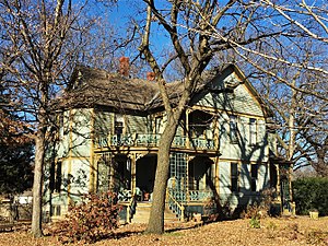
Parsons is a city in Labette County, Kansas, United States. As of the 2020 census, the population of the city was 9,600. It is the most populous city of Labette County, and the second-most populous city in the southeastern region of Kansas. It is home to Labette Community College and the Parsons State Hospital & Training Center.

<span class="mw-page-title-main">Chanute, Kansas</span> City in Neosho County, Kansas

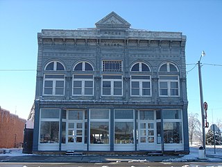
Chanute is a city in Neosho County, Kansas, United States. Founded on January 1, 1873, it was named after railroad engineer and aviation pioneer Octave Chanute. As of the 2020 census, the population of the city was 8,722. Chanute is home of Neosho County Community College.

<span class="mw-page-title-main">Erie, Kansas</span> City in Neosho County, Kansas

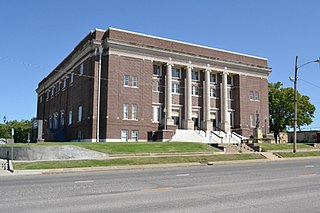
Erie is a city in and the county seat of Neosho County, Kansas, United States, and situated in the valley of the Neosho River, about a mile Northeast of the river. As of the 2020 census, the population of the city was 1,047.

<span class="mw-page-title-main">Galesburg, Kansas</span> City in Neosho County, Kansas

Galesburg is a city in Neosho County, Kansas, United States. As of the 2020 census, the population of the city was 149.

References

  1. 1 2 3 "QuickFacts; Neosho County, Kansas; Population, Census, 2020 & 2010". United States Census Bureau. Archived from the original on August 18, 2021. Retrieved August 18, 2021.
  2. "Find a County". National Association of Counties. Retrieved June 7, 2011.
  3. Blackmar, Frank Wilson (1912). Kansas: A Cyclopedia of State History, Volume 2. Standard Publishing Company. pp.  349.
  4. "US Gazetteer files: 2010, 2000, and 1990". United States Census Bureau. February 12, 2011. Retrieved April 23, 2011.
  5. "Annual Estimates of the Resident Population for Counties: April 1, 2020 to July 1, 2023". United States Census Bureau. Retrieved April 3, 2024.
  6. "U.S. Decennial Census". Census.gov. United States Census Bureau. Retrieved July 27, 2014.
  7. "Historical Census Browser". University of Virginia Library. Retrieved July 27, 2014.
  8. "Population of Counties by Decennial Census: 1900 to 1990". United States Census Bureau. Retrieved July 27, 2014.
  9. "Census 2000 PHC-T-4. Ranking Tables for Counties: 1990 and 2000" (PDF). United States Census Bureau. Archived (PDF) from the original on March 27, 2010. Retrieved July 27, 2014.
  10. "U.S. Census website". United States Census Bureau . Retrieved January 31, 2008.
  11. "Dave Leip's Atlas of U.S. Presidential Elections".
  12. "Map of Wet and Dry Counties". Alcoholic Beverage Control, Kansas Department of Revenue. November 2006. Archived from the original on October 8, 2007. Retrieved December 26, 2007.
  13. Burns, Tim (September 19, 2005). "Welcome To USD #247". Cherokee, USD 247. Archived from the original on August 10, 2007. Retrieved January 23, 2007.
  14. 1 2 "General Highway Map of Neosho County, Kansas" (PDF). Kansas Department of Transportation (KDOT). August 2011. Archived (PDF) from the original on July 14, 2023.

Further reading

County
Maps

37°34′N95°17′W / 37.567°N 95.283°W / 37.567; -95.283