Brown County, Kansas

Last updated

Brown County
BrownCoKScourthouse.JPG
Brown County Courthouse in Hiawatha (2011)
Map of Kansas highlighting Brown County.svg
Location within the U.S. state of Kansas
Kansas in United States.svg
Kansas's location within the U.S.
Coordinates: 39°48′N95°35′W / 39.800°N 95.583°W / 39.800; -95.583
CountryFlag of the United States.svg United States
StateFlag of Kansas.svg  Kansas
FoundedAugust 25, 1855
Named for Albert Gallatin Brown
Seat Hiawatha
Largest cityHiawatha
Area
  Total572 sq mi (1,480 km2)
  Land571 sq mi (1,480 km2)
  Water1.2 sq mi (3 km2)  0.2%
Population
 (2020) [1]
  Total9,508
  Density16.7/sq mi (6.4/km2)
Time zone UTC−6 (Central)
  Summer (DST) UTC−5 (CDT)
Area code 785
Congressional district 2nd
Website brcoks.org

Brown County is a county located in the northeast portion of the U.S. state of Kansas. Its county seat and most populous city is Hiawatha. [2] As of the 2020 census, the county population was 9,508. [1] The county was named after Albert G. Brown, a U.S. Senator from Mississippi and Kansas statehood advocate. The Kickapoo Indian Reservation of Kansas, the majority of the Sac and Fox Reservation, and the majority of the Iowa Reservation of Kansas and Nebraska are located within the county.

Contents

History

Early history

For many millennia, the Great Plains of North America was inhabited by nomadic Native Americans. From the 16th century to 18th century, the Kingdom of France claimed ownership of large parts of North America. In 1762, after the French and Indian War, France secretly ceded New France to Spain, per the Treaty of Fontainebleau.

19th century

In 1802, Spain returned most of the land to France, but keeping title to about 7,500 square miles. In 1803, most of the land for modern day Kansas was acquired by the United States from France as part of the 828,000 square mile Louisiana Purchase for 2.83 cents per acre.

In 1854, the Kansas Territory was organized, then in 1861 Kansas became the 34th U.S. state. Brown County was founded in 1855, [3] was named for Albert G. Brown. [4]

Geography

According to the U.S. Census Bureau, the county has a total area of 572 square miles (1,480 km2), of which 571 square miles (1,480 km2) is land and 1.2 square miles (3.1 km2) (0.2%) is water. [5] The Wolf River has its source in the county. [6] Brown State Fishing Lake, formerly known as "Brown County State Park" is in the county, 8 miles (13 km) east of Hiawatha.

Adjacent counties

Major highways

Sources: National Atlas, [7] U.S. Census Bureau [8]

Demographics

Population pyramid based on 2000 census age data USA Brown County, Kansas age pyramid.svg
Population pyramid based on 2000 census age data
Historical population
CensusPop.Note
1860 2,607
1870 6,823161.7%
1880 12,81787.8%
1890 20,31958.5%
1900 22,36910.1%
1910 21,314−4.7%
1920 20,949−1.7%
1930 20,553−1.9%
1940 17,395−15.4%
1950 14,651−15.8%
1960 13,229−9.7%
1970 11,685−11.7%
1980 11,9552.3%
1990 11,128−6.9%
2000 10,724−3.6%
2010 9,984−6.9%
2020 9,508−4.8%
2023 (est.)9,250 [9] −2.7%
U.S. Decennial Census [10]
1790-1960 [11] 1900-1990 [12]
1990-2000 [13] 2010-2020 [1]

As of the 2000 census, [14] there were 10,724 people, 4,318 households, and 2,949 families residing in the county. The population density was 19 people per square mile (7.3 people/km2). There were 4,815 housing units at an average density of 8 per square mile (3.1/km2). The racial makeup of the county was 86.87% White, 1.56% Black or African American, 8.82% Native American, 0.21% Asian, 0.01% Pacific Islander, 0.73% from other races, and 1.81% from two or more races. Hispanic or Latino of any race were 2.32% of the population.

There were 4,318 households, out of which 31.40% had children under the age of 18 living with them, 55.80% were married couples living together, 9.20% had a female householder with no husband present, and 31.70% were non-families. 28.80% of all households were made up of individuals, and 15.70% had someone living alone who was 65 years of age or older. The average household size was 2.44 and the average family size was 2.99.

In the county, the population was spread out, with 26.40% under the age of 18, 7.40% from 18 to 24, 24.00% from 25 to 44, 22.70% from 45 to 64, and 19.50% who were 65 years of age or older. The median age was 40 years. For every 100 females there were 93.50 males. For every 100 females age 18 and over, there were 89.80 males.

The median income for a household in the county was $31,971, and the median income for a family was $39,525. Males had a median income of $29,163 versus $19,829 for females. The per capita income for the county was $15,163. About 10.60% of families and 12.90% of the population were below the poverty line, including 16.40% of those under age 18 and 11.80% of those age 65 or over.

Government

Presidential elections

Presidential election results
United States presidential election results for Brown County, Kansas [15]
Year Republican Democratic Third party
No.%No.%No.%
2020 3,26272.96%1,10424.69%1052.35%
2016 2,90671.35%86321.19%3047.46%
2012 2,82970.85%1,07626.95%882.20%
2008 2,98568.21%1,31730.10%741.69%
2004 3,09269.99%1,26828.70%581.31%
2000 2,98563.63%1,51232.23%1944.14%
1996 2,68856.58%1,52932.18%53411.24%
1992 2,20341.61%1,47627.88%1,61530.51%
1988 3,05963.57%1,71935.72%340.71%
1984 3,89473.97%1,30324.75%671.27%
1980 3,59867.61%1,37025.74%3546.65%
1976 3,40764.96%1,74533.27%931.77%
1972 4,31478.92%1,03818.99%1142.09%
1968 3,74869.15%1,19922.12%4738.73%
1964 3,21357.01%2,38642.33%370.66%
1960 4,70772.25%1,77327.21%350.54%
1956 5,13876.95%1,51922.75%200.30%
1952 6,03180.51%1,44019.22%200.27%
1948 4,51867.98%2,06031.00%681.02%
1944 4,94772.98%1,81726.80%150.22%
1940 6,00869.18%2,63330.32%430.50%
1936 5,81462.38%3,49537.50%110.12%
1932 5,00557.73%3,60441.57%600.69%
1928 6,69276.77%2,00523.00%200.23%
1924 5,64768.94%1,86622.78%6788.28%
1920 5,24972.28%1,93726.67%761.05%
1916 4,28252.86%3,50343.25%3153.89%
1912 1,51231.24%1,77436.65%1,55432.11%
1908 2,77856.31%2,04441.44%1112.25%
1904 3,15868.62%1,24427.03%2004.35%
1900 3,13757.10%2,29841.83%591.07%
1896 2,87951.65%2,61846.97%771.38%
1892 2,56252.03%00.00%2,36247.97%
1888 2,69655.58%1,80337.17%3527.26%

Like all of Kansas outside the eastern cities, Brown County is overwhelmingly Republican, although its history of Yankee settlement means it has been thus for longer than certain other parts of the state. Brown was Alf Landon’s strongest county in his home state during his disastrous 1936 presidential campaign. FDR was never to win so much as 42 percent of the vote in any of his four Presidential elections; indeed no Democratic presidential nominee has ever won a majority in Brown County, with the highest percentage being 47 percent by William Jennings Bryan in 1896. A mortally divided Republican Party allowed Woodrow Wilson to win a plurality in 1912 with under 37 percent of the county’s vote – nonetheless since 1968 no Democrat has reached even that percentage.

Laws

Following amendment to the Kansas Constitution in 1986, the county remained a prohibition, or "dry", county until 2000, when voters approved the sale of alcoholic liquor by the individual drink without a food sales requirement. [16]

Education

Unified school districts [17]
School district office in neighboring county
Bureau of Indian Education-affiliated tribal schools

Communities

2005 map of Brown County (map legend) Map of Brown Co, Ks, USA.png
2005 map of Brown County (map legend)

List of townships / incorporated cities / unincorporated communities / extinct former communities within Brown County. [20]

Cities

‡ means a community has portions in an adjacent county.

Unincorporated communities

† means a community is designated a Census-Designated Place (CDP) by the United States Census Bureau.

Indian reservations

Townships

Brown County is divided into ten townships. The cities of Hiawatha, Horton, and Sabetha are considered governmentally independent and are excluded from the census figures for the townships. In the following table, the population center is the largest city (or cities) included in that township's population total, if it is of a significant size.

Township FIPS Population
center
PopulationPopulation
density
/km2 (/sq mi)
Land area
km2 (sq mi)
Water area
km2 (sq mi)
Water %Geographic coordinates
Hamlin297253443 (8)106 (41)0 (0)0.18% 39°57′1″N95°36′40″W / 39.95028°N 95.61111°W / 39.95028; -95.61111
Hiawatha317007394 (12)164 (63)0 (0)0.18% 39°50′25″N95°31′59″W / 39.84028°N 95.53306°W / 39.84028; -95.53306
Irving345003112 (6)137 (53)0 (0)0.04% 39°57′24″N95°23′36″W / 39.95667°N 95.39333°W / 39.95667; -95.39333
Mission472006453 (8)219 (84)2 (1)0.73% 39°43′14″N95°32′12″W / 39.72056°N 95.53667°W / 39.72056; -95.53667
Morrill48325 Morrill 5035 (12)105 (41)0 (0)0.24% 39°56′23″N95°43′20″W / 39.93972°N 95.72222°W / 39.93972; -95.72222
Padonia540252592 (6)107 (41)0 (0)0.14% 39°57′2″N95°31′4″W / 39.95056°N 95.51778°W / 39.95056; -95.51778
Powhattan573758744 (10)232 (90)0 (0)0.06% 39°43′49″N95°41′59″W / 39.73028°N 95.69972°W / 39.73028; -95.69972
Robinson60350 Robinson 4524 (10)116 (45)0 (0)0.25% 39°48′29″N95°23′49″W / 39.80806°N 95.39694°W / 39.80806; -95.39694
Walnut74875 Fairview 6654 (11)161 (62)1 (0)0.46% 39°50′53″N95°42′27″W / 39.84806°N 95.70750°W / 39.84806; -95.70750
Washington75525 Everest 5415 (12)116 (45)0 (0)0.17% 39°41′43″N95°24′41″W / 39.69528°N 95.41139°W / 39.69528; -95.41139
Sources: "Census 2000 U.S. Gazetteer Files". U.S. Census Bureau, Geography Division. Archived from the original on August 2, 2002.

See also

Community information for Kansas

Related Research Articles

<span class="mw-page-title-main">Montgomery County, Kansas</span> County in Kansas, United States

Montgomery County is a county located in Southeast Kansas. Its county seat is Independence, and its most populous city is Coffeyville. As of the 2020 census, the county population was 31,486. The county was named after Richard Montgomery, a major general during the American Revolutionary War.

<span class="mw-page-title-main">Wallace County, Kansas</span> County in Kansas, United States

Wallace County is a county located in the U.S. state of Kansas. Its county seat is Sharon Springs. As of the 2020 census, the county population was 1,512, making it the second-least populous county in Kansas. The county was created in 1868 and named in honor of Brigadier General W.H.L. Wallace, who had been mortally wounded in combat in the Battle of Shiloh. Wallace County is home to Mount Sunflower, the highest point in Kansas at 4,039 feet. Mount Sunflower is located approximately 15 miles (24 km) north-northwest of Weskan, less than one mile (1.6 km) from the Colorado state line. It is one of four Kansas counties to use the Mountain Time Zone rather than the Central Time Zone like the remainder of Kansas.

<span class="mw-page-title-main">Sumner County, Kansas</span> County in Kansas, United States

Sumner County is a county located in the U.S. state of Kansas. Its county seat is Wellington. As of the 2020 census, the population was 22,382. The county is named after Charles Sumner, a U.S. Senator from Massachusetts who was a leader of Reconstruction politics.

<span class="mw-page-title-main">Pottawatomie County, Kansas</span> County in Kansas, United States

Pottawatomie County is a county located in the U.S. state of Kansas. Its county seat is Westmoreland. As of the 2020 census, the county population was 25,348. The county was named for the Potawatomi tribe.

<span class="mw-page-title-main">Phillips County, Kansas</span> County in Kansas, United States

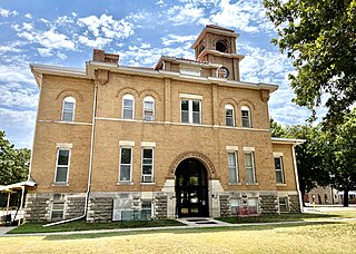
Phillips County is a county located in the U.S. state of Kansas. Its county seat and largest city is Phillipsburg. As of the 2020 census, the county population was 4,981. The county was named after William Phillips, a free-state abolition journalist and colonel in the American Civil War.

<span class="mw-page-title-main">Ottawa County, Kansas</span> County in Kansas, United States

Ottawa County is a county located in the U.S. state of Kansas. Its county seat and largest city is Minneapolis. As of the 2020 census, the county population was 5,735. The county was named after the Odawa tribe.

<span class="mw-page-title-main">Osage County, Kansas</span> County in Kansas, United States

Osage County is a county located in the U.S. state of Kansas. Its county seat is Lyndon, and its most populous city is Osage City. As of the 2020 census, the county population was 15,766. The county was originally organized in 1855 as Weller County, then renamed in 1859 after the Osage tribe.

<span class="mw-page-title-main">Neosho County, Kansas</span> County in Kansas, United States

Neosho County is a county located in Southeast Kansas. Its county seat is Erie. As of the 2020 census, the county population was 15,904. The county was named for the Neosho River, which passes through the county.

<span class="mw-page-title-main">Nemaha County, Kansas</span> County in Kansas, United States

Nemaha County is a county located in the northeastern part of the U.S. state of Kansas. Its county seat is Seneca. As of the 2020 census, the county population was 10,273. The county was named for the Nemaha River.

<span class="mw-page-title-main">Marshall County, Kansas</span> County in Kansas, United States

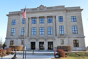
Marshall County is a county located in the U.S. state of Kansas. Its county seat and largest city is Marysville. As of the 2020 census, the county population was 10,038. The county was named after Frank J. Marshall, a state representative who operated the first ferry over the Big Blue River.

<span class="mw-page-title-main">Leavenworth County, Kansas</span> County in Kansas, United States

Leavenworth County is located in the U.S. state of Kansas and is part of the Kansas City metropolitan area. Its county seat and most populous city is Leavenworth. As of the 2020 census, the county population was 81,881. The county was named after Henry Leavenworth, a general in the Indian Wars who established Fort Leavenworth.

<span class="mw-page-title-main">Lane County, Kansas</span> County in Kansas, United States

Lane County is a county located in the U.S. state of Kansas. Its county seat is Dighton, the only incorporated city in the county. As of the 2020 census, the county population was 1,574, making it the third-least populous county in Kansas. The county was named after James Lane, a leader of the Jayhawker abolitionist movement and served as one of the first U.S. senators from Kansas.

<span class="mw-page-title-main">Jackson County, Kansas</span> County in Kansas, United States

Jackson County is a county in the U.S. state of Kansas. Its county seat and most populous city is Holton. As of the 2020 census, the county population was 13,232. The county, first named Calhoun County for pro-slavery South Carolina Senator John C. Calhoun, was renamed in 1859 for President Andrew Jackson. The Prairie Band Potawatomi Indian Reservation, near the center of the county, comprises about 18.5% of the county's area.

<span class="mw-page-title-main">Harvey County, Kansas</span> County in Kansas, United States

Harvey County is a county located in the U.S. state of Kansas. Its county seat and most populous city is Newton. As of the 2020 census, the county population was 34,024. The county was named for James Harvey, a U.S. senator and 5th governor of Kansas.

<span class="mw-page-title-main">Elk County, Kansas</span> County in Kansas, United States

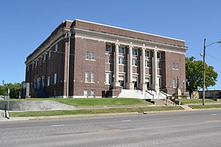
Elk County is a county located in the U.S. state of Kansas. Its county seat and most populous city is Howard. As of the 2020 census, the county population was 2,483. The county was named for the Elk River.

<span class="mw-page-title-main">Coffey County, Kansas</span> County in Kansas, United States

Coffey County is a county located in Eastern Kansas. Its county seat and most populous city is Burlington. As of the 2020 census, the county population was 8,360. It was named after A.M. Coffey, a territorial legislator and Free-Stater during Bleeding Kansas era.

<span class="mw-page-title-main">Clark County, Kansas</span> County in Kansas, United States

Clark County is a county located in the U.S. state of Kansas. Its county seat and most populous city is Ashland. As of the 2020 census, the county population was 1,991. The county was named after Charles Clarke.

<span class="mw-page-title-main">Cherokee County, Kansas</span> County in Kansas, United States

Cherokee County is a U.S. county located in Southeast Kansas. Its county seat is Columbus, and its most populous city is Baxter Springs. As of the 2020 census, the county population was 19,362. The county was named for the Cherokee tribe.

<span class="mw-page-title-main">Chautauqua County, Kansas</span> County in Kansas, United States

Chautauqua County is a county located in Southeast Kansas, United States. Its county seat and most populous city is Sedan. As of the 2020 census, the county population was 3,379. The county is named for Chautauqua County, New York, the birthplace of Edward Jaquins, a Kansas politician who was instrumental in getting the county established.

<span class="mw-page-title-main">Atchison County, Kansas</span> County in Kansas, United States

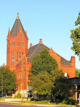
Atchison County is a county located in the northeast portion of the U.S. state of Kansas. Its county seat and most populous city is Atchison. As of the 2020 census, the county population was 16,348. The county was named in honor of David Atchison, a U.S. Senator from Missouri and border ruffian during the "Bleeding Kansas" era.

References

  1. 1 2 3 "QuickFacts; Brown County, Kansas; Population, Census, 2020 & 2010". United States Census Bureau. Archived from the original on August 15, 2021. Retrieved August 15, 2021.
  2. "Find a County". National Association of Counties. Archived from the original on May 31, 2011. Retrieved June 7, 2011.
  3. Blackmar, Frank Wilson (1912). Kansas: A Cyclopedia of State History, Embracing Events, Institutions, Industries, Counties, Cities, Towns, Prominent Persons, Etc. Standard Publishing Company. pp.  237.
  4. History of the State of Kansas: Containing a Full Account of Its Growth from an Uninhabited Territory to a Wealthy and Important State. A. T. Andreas. 1883. p.  710.
  5. "US Gazetteer files: 2010, 2000, and 1990". United States Census Bureau. February 12, 2011. Retrieved April 23, 2011.
  6. DeLorme (2003). Kansas Atlas & Gazetteer. p. 26. Yarmouth, Maine: DeLorme. ISBN   0-89933-342-7.
  7. National Atlas Archived December 5, 2008, at the Wayback Machine
  8. "U.S. Census Bureau TIGER shape files". Archived from the original on May 23, 2017. Retrieved December 5, 2017.
  9. "Annual Estimates of the Resident Population for Counties: April 1, 2020 to July 1, 2023". United States Census Bureau. Retrieved April 3, 2024.
  10. "U.S. Decennial Census". United States Census Bureau. Retrieved July 21, 2014.
  11. "Historical Census Browser". University of Virginia Library. Retrieved July 21, 2014.
  12. "Population of Counties by Decennial Census: 1900 to 1990". United States Census Bureau. Retrieved July 21, 2014.
  13. "Census 2000 PHC-T-4. Ranking Tables for Counties: 1990 and 2000" (PDF). United States Census Bureau. Archived (PDF) from the original on March 27, 2010. Retrieved July 21, 2014.
  14. "U.S. Census website". United States Census Bureau . Retrieved January 31, 2008.
  15. "Dave Leip's Atlas of U.S. Presidential Elections".
  16. "Map of Wet and Dry Counties". Alcoholic Beverage Control, Kansas Department of Revenue. November 2006. Archived from the original on October 8, 2007. Retrieved December 28, 2007.
  17. "2020 CENSUS - SCHOOL DISTRICT REFERENCE MAP: Brown County, KS" (PDF). U.S. Census Bureau. Archived (PDF) from the original on July 21, 2022. Retrieved July 21, 2022. - Text list
  18. "Hiawatha Schools USD 415". www.hiawathaschools.org.
  19. "USD 430 South Brown County". www.usd430.org.
  20. 1 2 "General Highway Map of Brown County, Kansas" (PDF). Kansas Department of Transportation (KDOT). February 2008. Archived (PDF) from the original on May 27, 2024.

Further reading

County
Maps