North Fork Village, Ohio

Last updated

North Fork Village, Ohio
Former CDP
OHMap-doton-North Fork Village.png
Location of North Fork Village, Ohio
Coordinates: 39°20′2″N83°1′41″W / 39.33389°N 83.02806°W / 39.33389; -83.02806
Country United States
State Ohio
County Ross
Area
  Total1.5 sq mi (4.0 km2)
  Land1.5 sq mi (4.0 km2)
  Water0.0 sq mi (0.0 km2)
Elevation
[1]
659 ft (201 m)
Population
 (2000)
  Total1,726
  Density1,129.6/sq mi (436.1/km2)
Time zone UTC-5 (Eastern (EST))
  Summer (DST) UTC-4 (EDT)
FIPS code 39-56546 [2]
GNIS feature ID1049018 [1]

North Fork Village is an unincorporated community and former census-designated place (CDP) in Ross County, Ohio, United States. The population was 1,726 at the 2000 census. It was not delineated as a CDP for the 2010 census.

Contents

Geography

North Fork Village is located at 39°20′2″N83°1′41″W / 39.33389°N 83.02806°W / 39.33389; -83.02806 (39.333981, -83.028177). [3]

According to the United States Census Bureau, the CDP had a total area of 1.5 square miles (3.9 km2), all land.

North Fork Paint Creek runs through the area. [4]

Demographics

As of the census [2] of 2000, there were 1,726 people, 723 households, and 466 families residing in the CDP. The population density was 1,129.6 inhabitants per square mile (436.1/km2). There were 780 housing units at an average density of 510.5 per square mile (197.1/km2). The racial makeup of the CDP was 94.44% White, 4.35% African American, 0.17% Native American, 0.75% Asian, and 0.29% from two or more races. Hispanic or Latino of any race were 0.64% of the population.

There were 723 households, out of which 31.1% had children under the age of 18 living with them, 49.7% were married couples living together, 11.8% had a female householder with no husband present, and 35.5% were non-families. 30.0% of all households were made up of individuals, and 11.9% had someone living alone who was 65 years of age or older. The average household size was 2.33 and the average family size was 2.91.

In the CDP the population was spread out, with 24.6% under the age of 18, 9.1% from 18 to 24, 29.1% from 25 to 44, 22.5% from 45 to 64, and 14.8% who were 65 years of age or older. The median age was 38 years. For every 100 females, there were 82.6 males. For every 100 females age 18 and over, there were 80.6 males.

The median income for a household in the CDP was $40,750, and the median income for a family was $53,068. Males had a median income of $46,950 versus $31,019 for females. The per capita income for the CDP was $22,314. About 2.2% of families and 4.4% of the population were below the poverty line, including 1.7% of those under age 18 and 10.0% of those age 65 or over.

Related Research Articles

<span class="mw-page-title-main">North El Monte, California</span> Census-designated place in California, United States

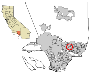
North El Monte is a census-designated place (CDP) in the San Gabriel Valley, in Los Angeles County, California, United States. The population was 3,723 at the 2010 census, up from 3,703 at the 2000 census.

<span class="mw-page-title-main">Silver Springs Shores, Florida</span> Census-designated place in Florida, United States

Silver Springs Shores is a census-designated place (CDP) in Marion County, Florida, United States. The population was 24,846 at the 2020 census. It is part of the Ocala Metropolitan Statistical Area.

<span class="mw-page-title-main">Green Valley, Maryland</span> Census-designated place in Maryland

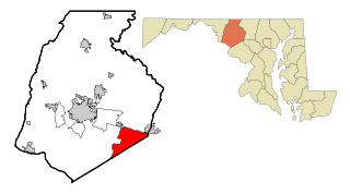
Green Valley is an unincorporated area and census-designated place (CDP) in southern Frederick County, Maryland, United States. The population was 12,643 at the 2020 census. The area was listed as a census-designated place in 2000 but not listed as part of any CDP at the 2010 census. It was re-designated a census-designated place for the 2020 census.

<span class="mw-page-title-main">Chester, Maryland</span> CDP in Maryland, United States

Chester is a census-designated place on Kent Island in Queen Anne's County, Maryland, United States. The population was 3,723 at the 2000 census.

<span class="mw-page-title-main">Paradise, Montana</span> CDP in Montana, United States

Paradise is a census-designated place (CDP) in Sanders County, Montana, United States. The population was 166 at the 2020 census.

<span class="mw-page-title-main">Country Lake Estates, New Jersey</span> Populated place in Burlington County, New Jersey, US

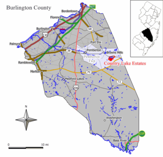
Country Lake Estates is an unincorporated community and census-designated place (CDP) located within Pemberton Township, in Burlington County, in the U.S. state of New Jersey. As of the 2010 United States Census, the CDP's population was 3,943.

<span class="mw-page-title-main">Beckett, New Jersey</span> Populated place in Gloucester County, New Jersey, US

Beckett is an unincorporated community and census-designated place (CDP) within Logan Township, in Gloucester County, in the U.S. state of New Jersey. As of the 2010 United States Census, the CDP's population was 4,847.

<span class="mw-page-title-main">Nenahnezad, New Mexico</span> CDP in New Mexico, United States

Nenahnezad is a census-designated place (CDP) in San Juan County, New Mexico, United States. The population was 726 at the 2000 census. Nenahnezad is a Chapter community just to the south of Fruitland, between the towns of Farmington and Shiprock. It is part of the Farmington Metropolitan Statistical Area.

<span class="mw-page-title-main">Rio Communities, New Mexico</span> City in New Mexico, United States

Rio Communities is a city in Valencia County, New Mexico, United States. Prior to its incorporation on May 16, 2013, it was a census-designated place (CDP). The CDP population was 4,723 as of the 2010 census.

<span class="mw-page-title-main">Lake Darby, Ohio</span> Census-designated place in Ohio, United States

Lake Darby is an unincorporated community and census-designated place in Franklin County, Ohio, United States, located mostly in Prairie Township and partly in Brown Township. It is more commonly known among locals as Darby Estates, which is also the name of the older housing development there, with the newer development called "West Point". As of the 2020 census, the CDP had a population of 4,731.

<span class="mw-page-title-main">Mount Healthy Heights, Ohio</span> Census-designated place in Ohio, United States

Mount Healthy Heights is a census-designated place (CDP) in Hamilton County, Ohio, United States. The population was 2,918 at the 2020 census.

<span class="mw-page-title-main">Woodbourne-Hyde Park, Ohio</span> Unincorporated community & former census-designated place in Ohio, United States

Woodbourne-Hyde Park is an unincorporated area in Washington Township in Montgomery County, Ohio, United States. A Suburb of Dayton. It was delineated as a census-designated place (CDP) at the 2000 census, at which time its population was 7,910. It was not delineated as a CDP for the 2010 census.

<span class="mw-page-title-main">Stony Prairie, Ohio</span> CDP in Ohio, United States

Stony Prairie is a census-designated place (CDP) in Sandusky County, Ohio, United States. The population was 1,284 at the 2010 census.

<span class="mw-page-title-main">Wickerham Manor-Fisher, Pennsylvania</span> Census-designated place in Pennsylvania, United States

Wickerham Manor-Fisher is a census-designated place (CDP) in Washington County, Pennsylvania, United States. The population was 1,728 at the 2010 census.

<span class="mw-page-title-main">La Victoria, Texas</span> CDP in Texas, United States

La Victoria is a census-designated place (CDP) in Starr County, Texas, United States. La Victoria went through some changes prior to the 2010 census. It gained area, had parts taken to form new CDPs, and lost additional area. Only a small part of 2010 La Victoria CDP was within the 2000 La Victoria CDP. The population was only 171 at the 2010 census down from 1,683 at the 2000 census.

<span class="mw-page-title-main">Mount Gay-Shamrock, West Virginia</span> Census-designated place in West Virginia, United States

Mount Gay-Shamrock is a census-designated place (CDP) in Logan County, West Virginia, United States.

Johnstown is a census-designated place (CDP) in Fremont County, Wyoming, United States. The population was 242 at the 2010 census.

<span class="mw-page-title-main">Provincetown (CDP), Massachusetts</span> Census-designated place in Massachusetts, United States

Provincetown (CDP) is a census-designated place (CDP) in the town of Provincetown in Barnstable County, Massachusetts, United States. The population was 2,642 at the 2010 census, out of 2,942 in the entire town.

<span class="mw-page-title-main">North Koolaupoko, Hawaii</span> An area of a census-designated place in Hawaii, United States

Waikāne or Waikane, also known as North Koʻolaupoko, is an area and census-designated place in the County of Honolulu, Hawaii, United States, on the island of Oʻahu. It had a population of 778 at the 2010 census. In Hawaiian, koʻolau poko means "short windward", referring to the fact that this is the shorter of the two windward districts on the island. Koʻolaupoko extends from Makapuʻu Point on the southeast to Kaʻōʻio Point on the north. Included within the district, south of North Koʻolaupoko, are the largest windward towns of Kāneʻohe, Kailua, and Waimānalo.

<span class="mw-page-title-main">Enterprise, West Virginia</span> Census-designated place in West Virginia, United States

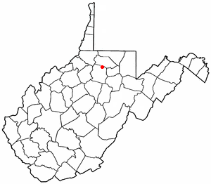
Enterprise is a census-designated place (CDP) in Harrison County, West Virginia, United States, along the West Fork River. The population was 961 at the 2010 census.

References

  1. 1 2 "US Board on Geographic Names". United States Geological Survey. October 25, 2007. Retrieved January 31, 2008.
  2. 1 2 "U.S. Census website". United States Census Bureau . Retrieved January 31, 2008.
  3. "US Gazetteer files: 2010, 2000, and 1990". United States Census Bureau. February 12, 2011. Retrieved April 23, 2011.
  4. Bennett, Henry Holcomb (1902). The County of Ross: A History of Ross County, Ohio, from the Earliest Days. Selwyn A. Brant. p. 277.