
State Route 105 is an east–west state highway in the northwestern portion of the U.S. state of Ohio. Its western terminus is at an interchange with Interstate 75 in Bowling Green that doubles as the southern terminus of State Route 64, and its eastern terminus is at State Route 19 in Oak Harbor. For its final 0.4 miles (0.64 km), the route overlaps State Route 163 which continues east.

State Route 241 is a north–south state highway in the northeastern portion of the U.S. state of Ohio. Its southern terminus is at U.S. Route 62 in Millersburg, and its northern terminus is at State Route 18 in Akron.

State Route 246 (SR 246) is a 7.77-mile-long (12.50 km) east–west state highway in the northwestern part of the U.S. state of Ohio. The western terminus of SR 246 is at the underpass and future junction with Interstate 475/U.S. Route 23 (I-475/US 23) at the western border of Toledo. Its eastern terminus is at a signalized intersection with SR 51 in downtown Toledo.

State Route 88 is a highway generally running in an east–west direction in the northeastern portion of the U.S. state of Ohio. Its southern terminus is in Portage County at SR 59 at the intersection of Freedom Street with Main Street in Ravenna. SR 88 is labeled north-south southwest of U.S. Route 422 (US 422) and SR 168/SR 528, and labeled east-west east of there. SR follows a northerly direction for a little more than one mile (1.6 km) along Freedom Street, to the SR 14 and SR 44 concurrency bypass. From here, the route heads in a northeasterly direction. Its next intersection is with SR 700, at the southern terminus of the latter route. One-quarter mile (0.40 km) further to the northeast, SR 88 joins SR 303 for about one-half mile (0.80 km). SR 88 then continues northeast, crossing over Interstate 80 and the Ohio Turnpike, before turning due north as it enters Garrettsville. Here, as South Street, the route intersects SR 82, then becomes North Street before exiting the corporation limits.

State Route 243 is an east–west state highway in the southern portion of the U.S. state of Ohio. The western terminus of SR 243 is at a diamond interchange with the U.S. Route 52 (US 52) in Coal Grove. The eastern terminus of the state highway is at its signalized junction with State Route 7 approximately 1.25 miles (2.01 km) west of Proctorville near the northern banks of the Ohio River.

State Route 173 (SR 173) is located in northeastern Ohio, and runs east–west from State Route 44, about 4 miles (6.4 km) north of Louisville, Ohio to State Route 14 and State Route 9 in downtown Salem, Ohio. It primarily passes through Stark and Columbiana counties, though it also straddles the county line between Mahoning County and Columbiana County for some of its length. Much of the route is also run in concurrency with U.S. Route 62.

State Route 31 (SR 31) is a 32.12-mile-long (51.69 km) Ohio State Route that runs between Marysville and Kenton in the US state of Ohio. The southern terminus of SR 31 is at an intersection with SR 38 in downtown Marysville and the northern terminus is at an intersection with U.S. Route 68 (US 68), in downtown Kenton. None of the highway is listed on the National Highway System. Most of the route is a rural two-lane highway and passes through both farmland and residential properties.

State Route 167 is a 14.08-mile-long (22.66 km) east–west state highway in the northeastern portion of the U.S. state of Ohio. Its western terminus is at the northern end of the SR 46 and SR 307 concurrency in Jefferson, and its eastern terminus is at the Pennsylvania state line about 13 miles (21 km) south of Conneaut, where Pennsylvania Route 198 continues east. The route was designated in 1923, and has been rerouted three times since.

State Route 39 is a primarily east–west running state highway in north-central and northeastern portion of the U.S. state of Ohio. The route runs through seven counties on its approximately 155-mile (249 km) trip through the region. Its western terminus is at State Route 103 near New Washington, and its eastern terminus is at PA 68 near East Liverpool.

State Route 97 (SR 97) is a 34.57-mile (55.64 km) state route that runs between Galion and south of Loudonville in the US state of Ohio. Most of the route is a rural two-lane highway and passes through woodland, farmland and residential areas. For some of its path, SR 97 runs near the Clear Fork Mohican River. The highway was first signed in 1923 on a section of the current alignment. The route has been extended a few times; the first in 1926 extending the route to SR 3. The first section of road was paved in 1938. Another extension happened in 1939 with the route heading west to Galion. The final section paved was completed in the mid-1950s.

State Route 98 is a north–south state highway in the northern portion of the U.S. state of Ohio. Its southern terminus is at the SR 47/SR 423 concurrency in Waldo, and its northern terminus is at SR 61 in Plymouth.

State Route 132 (SR 132) is a north–south state highway in the southwestern portion of the U.S. state of Ohio. Its southern terminus is at its interchange with U.S. Route 52 in New Richmond and its northern terminus is at its intersection with SR 350 and SR 133 in Clarksville.
U.S. Route 50 runs east–west across the southern part of the U.S. state of Ohio, passing through Cincinnati, Chillicothe, and Athens. It is mainly a two-lane road except for the easternmost and westernmost parts. Near Athens it becomes part of State Route 32, a four-lane divided highway known as Corridor D, and from Reedsville to the Ohio/West Virginia border it also overlaps State Route 7 before crossing into Parkersburg, West Virginia.

State Route 164 (SR 164) is a state highway passing through four counties in east-central Ohio. The route runs in a general southwest to northeast fashion, and is signed north–south accordingly. The southern terminus is at an intersection with State Route 212 1-mile (1.6 km) south of Leesville, and the northern terminus is at Interstate 680 and Western Reserve Road on the Beaver and Boardman township boundary between North Lima and Boardman. The southern part of the route serves more rural areas while it makes its way through larger villages and cities toward its northern end.

State Route 133 (SR 133) is a north–south state highway in the southwestern portion of the U.S. state of Ohio. Its southern terminus is at its interchange with U.S. Route 52 near Felicity and its northern terminus is at its interchange with SR 350 in Clarksville.

State Route 134 (SR 134) is a north–south state highway in the southwestern portion of the U.S. state of Ohio. Its southern terminus is at its intersection with SR 32 in Sardinia and its northern terminus is at its intersection with Main Street in Port William.

State Route 136 (SR 136) is a north–south state highway in the southwestern portion of the U.S. state of Ohio. Its southern terminus is at its interchange with U.S. Route 52 in Manchester and its northern terminus is at its interchange with U.S. Route 62 near Winchester.

State Route 236 is a two-lane north–south state highway in the northeastern portion of the U.S. state of Ohio. Its southern terminus is at a signalized intersection with State Route 21 in the northern end of Massillon. The northern terminus of the route is at a Y-intersection with State Route 93 in New Franklin. The route follows part of the Ohio & Erie Canal Towpath.
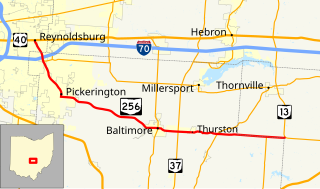
State Route 256 (SR 256) is a 25.99-mile (41.83 km) east–west state highway in the central portion of the U.S. state of Ohio. The western terminus of SR 256 is at a T-intersection with U.S. Route 40 (US 40) in Reynoldsburg. Its eastern terminus is at a T-intersection with SR 13 approximately 5.50 miles (8.85 km) west-northwest of Somerset.

State Route 148 (SR 148) is an east–west state highway in eastern Ohio. Existing entirely in the southern portion of Belmont County, SR 148 has its western terminus at SR 800 approximately two miles (3.2 km) south of Barnesville. The eastern terminus of SR 148 is at SR 7 in Powhatan Point. From the SR 26 intersection easterly to its endpoint at SR 7, SR 148 generally runs in parallel to the Captina Creek.


