U.S. Route 23 or U.S. Highway 23 (US 23) is a major north–south United States Numbered Highway between Jacksonville, Florida, and Mackinaw City, Michigan. It is an original 1926 route which originally reached only as far south as Portsmouth, Ohio, and has since been extended. It was formerly part of the major highway known as the Dixie Highway. The highway's southern terminus is in Jacksonville, Florida, at US 1/US 17. The northern terminus is at Interstate 75 (I-75) in Mackinaw City, Michigan.
Interstate 475 (I-475) is an auxiliary Interstate Highway in Ohio that is a 20.37-mile (32.78 km) western bypass of Toledo. The southern terminus is I-75 exit 192 near Perrysburg. From the southern terminus to exit 14, I-475 is cosigned with US Route 23 (US 23) and is signed the north–south section of I-475. From exit 14 to the eastern (northernmost) terminus at I-75 exit 204 in central Toledo, it is signed the east–west section of I-475.

State Route 12 is a generally northeast-southwest route in Ohio. Its western terminus is at SR 115 and SR 189 in Vaughnsville, and its eastern terminus is at SR 53 just south of Fremont.

State Route 163 (SR 163) is a 46.24-mile (74.42 km) long east–west state highway in the northwestern portion of the U.S. state of Ohio. The western terminus of SR 163 is at a T-intersection with the duplex of U.S. Route 20 (US 20) and US 23 approximately 6 miles (9.7 km) southeast of the city limits of Perrysburg. Its eastern terminus is at its intersection with Hartshorn Road nearly 2 miles (3.2 km) west of the village limits of Marblehead, on the peninsula formed by Lake Erie and Sandusky Bay.

State Route 613 is an east–west state highway in the northwestern portion of the U.S. state of Ohio. Its western terminus is at the Indiana state line 4 miles (6.4 km) west of Payne, and its eastern terminus is at US 23 in Fostoria.

State Route 53 is a north–south state highway in the U.S. state of Ohio. Its southern terminus is at the beginning of the U.S. 68/S.R. 67 concurrency in Kenton, Ohio, and its northern terminus is on Catawba Island in Ottawa County, north of Port Clinton.
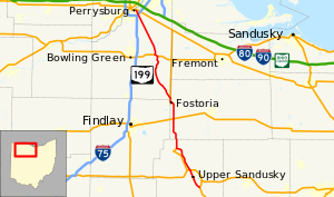
State Route 590 is a north–south state highway in the northwestern portion of the U.S. state of Ohio. The southern terminus of SR 590 is at a signalized intersection with SR 12 in the village of Bettsville. Its northern terminus is at a T-intersection with SR 2 just south of Ottawa National Wildlife Refuge, and approximately 5 miles (8.0 km) north of Rocky Ridge.

State Route 65 is a north–south highway in western Ohio. Its southern terminus is at State Route 47 near Sidney, and its northern terminus is at its interchange with Interstate 280 in Toledo. From south to north, the route passes through the cities of Jackson Center, Uniopolis, Lima, Columbus Grove, Ottawa, Leipsic, Belmore, McClure, Grand Rapids, Perrysburg, Rossford, and Toledo.

State Route 18 is an east–west highway in northern Ohio. It is the sixth longest state route in the state. Its western terminus is at the Indiana state line near Hicksville, where the route continues in Indiana as State Road 8, and its eastern terminus is at State Route 91 in Akron.

State Route 113 is an east–west highway in north central and northeastern Ohio. Its western terminus is at SR 269 in Bellevue, where SR 113 is initially concurrent with US 20 and SR 18; its eastern terminus is at the US 6 / SR 2 concurrency in Lakewood. Most of its eastern portion is also in a concurrency with US 20.

State Route 300 is a 6.33-mile (10.19 km) long north–south state highway in northwestern Ohio, a U.S. state. The southern terminus of SR 300 is at a T-intersection with U.S. Route 6 (US 6) approximately 1.50 miles (2.41 km) west of the village of Helena. Its northern terminus is at US 20 just over 2.50 miles (4.02 km) southeast of Woodville.

State Route 795 is an east–west state highway in northwestern Ohio, a U.S. state. The western terminus of SR 795 is at US 20 in Perrysburg, at the signalized intersection that doubles as the northern terminus of SR 199. Its eastern terminus is at a signalized intersection with SR 51 about 0.5 miles (0.80 km) southeast of Millbury.

State Route 15 is a north–south and east–west route in northwestern Ohio. Its southern (eastern) terminus is at its interchange with U.S. Route 23/State Route 103 (US 23/SR 103) near Carey, and its northern (western) terminus is at the Michigan state line north of Pioneer, where the route continues in Michigan as M-99. The route is signed east–west from Carey to Bryan, and it is signed north–south from there to the Michigan state line.

State Route 101 (SR 101) is a southwest-northeast state highway in the north central portion of the U.S. state of Ohio. Its western terminus is at the junction of SR 18 and SR 53 in Tiffin; it runs concurrently with SR 18 for about one mile (1.6 km). Its eastern terminus is at the junction of U.S. Route 6 (US 6) and SR 4 in Sandusky; it runs concurrently with US 6 for just over one and a half miles (2.4 km) to its western terminus.

State Route 510 is a north–south state highway in the northern portion of Ohio. The entirety of SR 510 lies within Sandusky County. Its southern terminus is at SR 101 in Clyde, and its northern terminus is at U.S. Route 6 (US 6) between Fremont and Sandusky.
State Route 99 (SR 99) is a north–south state highway in the north-central portion of the U.S. state of Ohio. The highway's southern terminus is in the southern end of Willard at a T-intersection with U.S. Route 224 (US 224). Its northern terminus is at a roundabout junction with SR 4 about 6 miles (9.7 km) southwest of the city limits of Sandusky.

State Route 110 (SR 110) is a 10.73-mile (17.27 km) state route that runs between Napoleon and north of McClure in the US state of Ohio. Most of the route is a rural two-lane highway and passes through both farmland and commercial properties. For much of its path, SR 110 runs generally parallel to the south of the Maumee River.

U.S. Route 30 (US 30) is a United States Numbered Highway that runs from Astoria, Oregon, to Atlantic City, New Jersey. In the state of Ohio, it is a major, 245-mile-long (394 km), east–west highway that runs through the northern section of the state. Overall, the highway runs through rural areas dominated by farm fields or woodlands; some segments are urban in character in the Mansfield and Canton areas.

U.S. Route 6 (US 6) is a part of the United States Numbered Highway System that runs from Bishop, California, to Provincetown, Massachusetts. In Ohio, the road runs west–east from the Indiana state line near Edgerton to the Pennsylvania state line near Andover. The 248.002 miles (399.121 km) that lie in Ohio are maintained by the Ohio Department of Transportation (ODOT). US 6 serves the major cities of Sandusky, Lorain, and Cleveland. The highway is also called the Grand Army of the Republic Highway to honor the Union forces of the U.S. Civil War. The alternate name was designated in 1953.
U.S. Route 23 (US 23) is a United States Numbered Highway that runs from Jacksonville, Florida, to Mackinaw City, Michigan. In the state of Ohio, it is a major north–south state highway that runs from the Kentucky border at Portsmouth to the Michigan border at Sylvania.