State Route 246 (SR 246) is a 6.07-mile (9.77 km) long east–west state highway in northwestern Ohio, a U.S. state. The western terminus of SR 246 is at a signalized intersection with U.S. Route 20 (US 20) in the Reynolds Corners neighborhood of Toledo. Its eastern terminus is at a signalized intersection with SR 51 in downtown Toledo.

State Route 247 (SR 247) is a 30.49-mile (49.07 km) long north–south state highway in the southern part of the U.S. state of Ohio. SR 247 has its southern terminus at a dead end overlooking the Ohio River 0.35 miles (0.56 km) south of its junction with U.S. Route 52 (US 52), nearly 4.75 miles (7.64 km) northeast of Manchester. The northern terminus of SR 247 is at a signalized intersection with State Route 73 in Hillsboro.

State Route 231 (SR 231) is a 35.77-mile (57.57 km) long north–south state highway in the northwestern quadrant of the U.S. state of Ohio. SR 231 has its southern terminus at a CSX railroad crossing in the village of Morral. Its northern terminus is in downtown Tiffin at a signalized intersection with SR 18 and SR 101, following a 0.35 miles (0.56 km) long concurrency with SR 100, which continues north as a solo route north of this point.

State Route 380 (SR 380) is a north–south state highway in the southwestern quadrant of the U.S. state of Ohio. The southern terminus of SR 380 is at its junction with the concurrency of U.S. Route 22 (US 22) and SR 3 nearly 3 miles (4.8 km) northeast of Clarksville. Its northern terminus is in downtown Xenia, following a brief concurrency with US 68, at the signalized intersection where the U.S. route meets US 42.
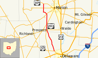
State Route 203 is a 22.14-mile (35.63 km) long north–south state highway in the central portion of the U.S. state of Ohio. The southern terminus of SR 203 is at a four-way stop intersection with SR 37 just 0.50 miles (0.80 km) northwest of the city limits of Delaware. Its northern terminus is at SR 309 approximately 4 miles (6.4 km) northwest of Marion.

State Route 99 (SR 99) is a north–south state highway in the north-central portion of the U.S. state of Ohio. The highway's southern terminus is in the southern end of Willard at a T-intersection with U.S. Route 224 (US 224). Its northern terminus is at its junction with SR 4 about 6 miles (9.7 km) southwest of the city limits of Sandusky.

State Route 96 is an east–west state highway in the northern portion of the U.S. state of Ohio. The southern terminus of SR 96 is at a T-intersection with SR 98 nearly 2 1⁄2 miles (4.0 km) northeast of Bucyrus. Its eastern terminus is at an interchange with US 42 and US 250 in the eastern portion of Ashland.
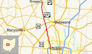
State Route 257 is a 26.19-mile (42.15 km) north - south state highway in the central portion of the U.S. state of Ohio. The highway's southern terminus is in the northwestern Columbus suburb of Dublin at a roundabout intersection with U.S. Route 33 and SR 161. This mainly two-lane highway follows the eastern side of the Scioto River from Dublin to its junction with US 42. After crossing over the river with the U.S. highway, SR 257 parallels the river's western bank. SR 257 has its northern terminus at a T-intersection with SR 47 on the western village limits of Prospect. SR 257 was created in 1926, and extended in 1935 and 1937.

State Route 314 (SR 314) is a north–south state highway in the northern portion of the U.S. state of Ohio. The southern terminus of SR 314 is at a T-intersection with the duplex of U.S. Route 36 (US 36) and SR 3 in Centerburg. Its northern terminus is at a T-intersection with State Route 61 less than 1 mile (1.6 km) south of the city limits of Shelby.

State Route 131 (SR 131) is a 30.05-mile (48.36 km) long east–west state highway in the southwestern quadrant of the U.S. state of Ohio. The western terminus of SR 131 is at a signalized intersection with U.S. Route 50 (US 50) in the eastern Cincinnati suburb of Milford. Its eastern terminus is at a T-intersection with SR 138 approximately 7.50 miles (12.07 km) southwest of Hillsboro.

State Route 143 is a north–south state highway in the southern portion of the U.S. state of Ohio. The southern terminus of SR 143 is at a T-intersection with the concurrency of SR 7 and SR 124 approximately one mile (1.6 km) west of the village of Pomeroy. Its northern terminus is at a T-intersection with U.S. Route 50 (US 50) nearly 2.75 miles (4.43 km) southwest of Albany.

State Route 144 is a north–south state highway in the southern portion of Ohio, a U.S. state. The southern terminus of State Route 144 is at is a T-interchange with State Route 124 in Hockingport. Its northern terminus is at another T-intersection, this time with State Route 329 in the unincorporated community of Stewart.

State Route 209 is an east–west state highway in eastern Ohio, a U.S. state. The western terminus of State Route 209 is at a T-intersection with State Route 83 approximately 3.75 miles (6.04 km) north of New Concord. State Route 209's eastern terminus is concurrent with the northern terminus of State Route 821 at Interstate 77 at its exit 41 in Byesville, just 2.25 miles (3.62 km) southeast of the Interstate's interchange with Interstate 70.

State Route 215 is an east–west state highway in the southeastern portion of the U.S. state of Ohio. The western terminus of SR 215 is at a T-intersection with SR 821 just one-half mile (0.80 km) southeast of the village of Belle Valley and SR 821's junction with Interstate 77. Its eastern terminus is at another T-intersection, this time with SR 285 just outside the village of Sarahsville.
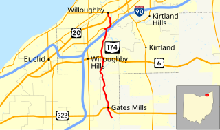
State Route 174 (SR 174) is a 9.56-mile (15.39 km) long north–south state highway in the northeastern quadrant of the U.S. state of Ohio. The highway runs from its southern terminus at a T-intersection with Old Mill Road in a quiet residential neighborhood in the eastern Cleveland suburb of Gates Mills to its northern terminus at a signalized intersection with U.S. Route 20 (US 20) in Willoughby that doubles as the eastern terminus of SR 640.

State Route 175 (SR 175) is a 15.70-mile (25.27 km) long north–south state highway in the northeastern part of the U.S. state of Ohio. The southern terminus of SR 175 is at a signalized intersection with SR 43 in Solon. Its northern terminus is at a signailzed intersection with SR 283 in Euclid.

State Route 158 is a two-lane north–south state highway located in the central portion of the U.S. state of Ohio. State Route 158's southern terminus is in downtown Lancaster at its junction with U.S. Route 22, State Route 37 and State Route 188. Its northern terminus is at a T-intersection US 40 in Kirkersville.

State Route 345 (SR 345) is a north–south state highway in the eastern portion of the U.S. state of Ohio. The southern terminus of SR 345 is at a signalized intersection with the SR 13/SR 37 concurrency in New Lexington. Its northern terminus is at a T-intersection with U.S. Route 22 (US 22) in the unincorporated community of East Fultonham.

State Route 222 (SR 222) is a 29.14-mile-long (46.90 km) north–south state highway in the southwestern part of the U.S. state of Ohio. The southern terminus of SR 222 is at U.S. Route 52 (US 52) in the village of Chilo. Its northern terminus is at a signalized T-intersection with US 50 approximately 3.50 miles (5.63 km) northwest of Batavia.
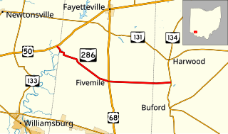
State Route 286 (SR 286) is a 9.97-mile-long (16.05 km) east–west state highway in the southwestern portion of the U.S. state of Ohio. The western terminus of SR 286 is at U.S. Route 50 (US 50) nearly five miles (8.0 km) southwest of the village of Fayetteville. Its eastern terminus is at SR 134 approximately seven and a quarter miles (11.7 km) northwest of Sardinia.