St. Martin, Ohio

Last updated

St. Martin, Ohio
OHMap-doton-St. Martin.png
Location of St. Martin, Ohio
Coordinates: 39°12′51″N83°53′29″W / 39.21417°N 83.89139°W / 39.21417; -83.89139
Country United States
State Ohio
County Brown
Township Perry
Area
[1]
  Total1.94 sq mi (5.02 km2)
  Land1.94 sq mi (5.02 km2)
  Water0.00 sq mi (0.00 km2)
Elevation
[2]
978 ft (298 m)
Population
 (2020)
  Total200
  Density103.25/sq mi (39.86/km2)
Time zone UTC-5 (Eastern (EST))
  Summer (DST) UTC-4 (EDT)
FIPS code 39-69666 [3]
GNIS feature ID1057993 [2]

St. Martin is an unincorporated community and former village in Brown County, Ohio, United States. The community is served by the Fayetteville (45118) post office. [4] The population was 200 at the 2020 census. [5] In November 2011, voters chose to unincorporate St. Martin, and it now falls solely under the jurisdiction of Perry Township. [6] [7]

Contents

Geography

St. Martin is located at 39°12′51″N83°53′29″W / 39.21417°N 83.89139°W / 39.21417; -83.89139 (39.214219, -83.891475). [8]

According to the 2010 census, the village had a total area of 1.09 square miles (2.82 km2), all land. [9]

Demographics

Historical population
CensusPop.Note
2000 91
2010 12941.8%
2020 20055.0%
U.S. Decennial Census [10]

2010 census

As of the census [11] of 2010, there were 129 people, 47 households, and 36 families living in the village. The population density was 118.3 inhabitants per square mile (45.7/km2). There were 50 housing units at an average density of 45.9 per square mile (17.7/km2). The racial makeup of the village was 99.2% White and 0.8% from two or more races.

There were 47 households, out of which 29.8% had children under the age of 18 living with them, 72.3% were married couples living together, 2.1% had a female householder with no husband present, 2.1% had a male householder with no wife present, and 23.4% were non-families. 14.9% of all households were made up of individuals, and 10.7% had someone living alone who was 65 years of age or older. The average household size was 2.66 and the average family size was 2.97.

The median age in the village was 49.2 years. 19.4% of residents were under the age of 18; 6.2% were between the ages of 18 and 24; 16.3% were from 25 to 44; 42.7% were from 45 to 64; and 15.5% were 65 years of age or older. The gender makeup of the village was 48.8% male and 51.2% female.

2000 census

As of the census [3] of 2000, there were 91 people, 32 households, and 28 families living in the village. The population density was 78.3 inhabitants per square mile (30.2/km2). There were 34 housing units at an average density of 29.3 per square mile (11.3/km2). The racial makeup of the village was 100.00% White. Hispanic or Latino of any race were 1.10% of the population.

There were 32 households, out of which 40.6% had children under the age of 18 living with them, 81.3% were married couples living together, 6.3% had a female householder with no husband present, and 12.5% were non-families. 12.5% of all households were made up of individuals, and 6.3% had someone living alone who was 65 years of age or older. The average household size was 2.84 and the average family size was 3.11.

In the village the population was spread out, with 28.6% under the age of 18, 6.6% from 18 to 24, 26.4% from 25 to 44, 30.8% from 45 to 64, and 7.7% who were 65 years of age or older. The median age was 40 years. For every 100 females, there were 102.2 males. For every 100 females age 18 and over, there were 103.1 males.

The median income for a household in the village was $60,417, and the median income for a family was $60,833. Males had a median income of $33,750 versus $28,125 for females. The per capita income for the village was $18,833. None of the population and none of the families were below the poverty line.

See also

Related Research Articles

<span class="mw-page-title-main">Maunaloa, Hawaii</span> Census-designated place in Hawaii, United States

Maunaloa or Mauna Loa is a census-designated place (CDP) in Maui County, Hawaiʻi, United States, in the western part of the island of Molokai. The population was 435 at the 2020 census.

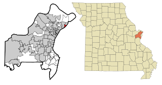
Rosewood Heights is an unincorporated community and census-designated place (CDP) in Madison County, Illinois, United States. The population was 3,971 at the 2020 census. It is part of the Metro East region of the Greater St. Louis metropolitan area.

<span class="mw-page-title-main">East Carondelet, Illinois</span> Village in Illinois, United States

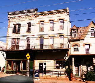
East Carondelet is a village in St. Clair County, Illinois, United States. The population was 499 as of the 2010 census.

<span class="mw-page-title-main">Greens Fork, Indiana</span> Town in Indiana, United States

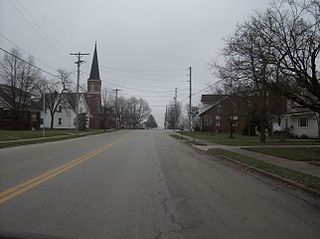
Greens Fork is a town in Clay Township, Wayne County, in the U.S. state of Indiana. The population was 423 at the 2010 census.

<span class="mw-page-title-main">Macksburg, Iowa</span> City in Iowa, United States

Macksburg is a city in Madison County, Iowa, United States. The population was 97 at the time of the 2020 census. It is part of the Des Moines–West Des Moines Metropolitan Statistical Area.

<span class="mw-page-title-main">Martin, Michigan</span> Village in Michigan, United States

Martin is a village in southeastern Allegan County in the U.S. state of Michigan. The population was 410 at the 2010 census.

<span class="mw-page-title-main">St. Martin, Minnesota</span> City in Minnesota, United States

St. Martin or Saint Martin, Smartin to locals, is a city in Stearns County, Minnesota, United States. The population was 308 at the 2010 census. It is part of the St. Cloud Metropolitan Statistical Area.

<span class="mw-page-title-main">St. Martins, Missouri</span> City in Missouri, United States

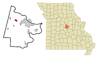
St. Martins or Saint Martins is a city in Cole County, Missouri, United States. The population was 1,191 at the 2020 census. It is part of the Jefferson City, Missouri Metropolitan Statistical Area.

<span class="mw-page-title-main">Riverview, St. Louis County, Missouri</span> Village in Missouri, United States

Riverview is a village in St. Louis County, Missouri, United States. The population was 2,397 at the 2020 census.

<span class="mw-page-title-main">Wilbur Park, Missouri</span> Village in Missouri, United States

Wilbur Park is a village in St. Louis County, Missouri, United States. The population was 439 at the 2020 census.

<span class="mw-page-title-main">Champ, Missouri</span> Village in Missouri, United States

Champ is a village in St. Louis County, Missouri, United States. The population was 10 at the 2020 census.

<span class="mw-page-title-main">Hanley Hills, Missouri</span> Village in Missouri, United States

Hanley Hills is a village in St. Louis County, Missouri, United States. The population was 2,101 at the 2010 census.

<span class="mw-page-title-main">Uplands Park, Missouri</span> Village in Missouri, United States

Uplands Park is a village in St. Louis County, Missouri, United States. The population was 445 at the 2010 census. The village is one of many small majority black communities located in the Natural Bridge corridor of mid-St. Louis County, characterized by small homes on small lots.

<span class="mw-page-title-main">Osgood, Ohio</span> Village in Ohio, United States

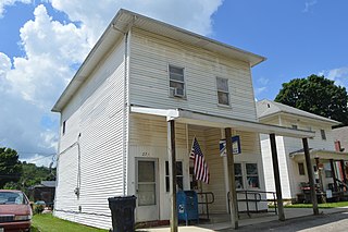
Osgood is a village in Darke County, Ohio, United States. The population was 306 at the 2020 census.

<span class="mw-page-title-main">St. Louisville, Ohio</span> Village in Ohio, United States

St. Louisville is a village in Licking County, Ohio, United States, along the North Fork of the Licking River. The population was 352 at the 2020 census.

<span class="mw-page-title-main">Ashley, Pennsylvania</span> Borough in Pennsylvania, United States

Ashley is a borough in Luzerne County, Pennsylvania, one mile (2 km) from Wilkes Barre. The population was 2,588 at the 2020 census.

<span class="mw-page-title-main">Woodman, Wisconsin</span> Village in Wisconsin, United States

Woodman is a village in Grant County in the U.S. state of Wisconsin. The population was 132 at the 2010 census. The village is located within the Town of Woodman.

<span class="mw-page-title-main">Marquette, Wisconsin</span> Village in Wisconsin, United States

Marquette is a village in Green Lake County, Wisconsin, United States. The population was 150 at the 2010 census. The village is located within the Town of Marquette. Marquette uses the postal code 53947.

<span class="mw-page-title-main">Bangor, Wisconsin</span> Village in Wisconsin, United States

Bangor is a village in La Crosse County, Wisconsin, United States, along the La Crosse River. It is part of the La Crosse-Onalaska, WI-MN Metropolitan Statistical Area. The population was 1,437 as of the 2020 Census. The village is located partially within the Town of Bangor.

<span class="mw-page-title-main">Wilton, Wisconsin</span> Village in Wisconsin, United States

Wilton is a village in Monroe County, Wisconsin, United States. The population was 504 at the 2010 census. The village is located partially within the Town of Wilton and partially within the Town of Wellington.

References

  1. "ArcGIS REST Services Directory". United States Census Bureau. Retrieved September 20, 2022.
  2. 1 2 "US Board on Geographic Names". United States Geological Survey. October 25, 2007. Retrieved January 31, 2008.
  3. 1 2 "U.S. Census website". United States Census Bureau . Retrieved January 31, 2008.
  4. Zip Code Lookup
  5. "Geographic Identifiers: 2010 Demographic Profile Data (G001): St. Martin village, Ohio". U.S. Census Bureau, American Factfinder. Archived from the original on February 12, 2020. Retrieved February 21, 2014.
  6. "St. Martin dissolved". Archived from the original on January 29, 2013. Retrieved July 29, 2012.
  7. Fugleberg, Jeremy (February 25, 2016). "Hit by floods and budget cuts, village to vote on disappearing". The Cincinnati Enquirer. Retrieved February 26, 2016.
  8. "US Gazetteer files: 2010, 2000, and 1990". United States Census Bureau. February 12, 2011. Retrieved April 23, 2011.
  9. "US Gazetteer files 2010". United States Census Bureau. Archived from the original on January 25, 2012. Retrieved January 6, 2013.
  10. "Census of Population and Housing". Census.gov. Retrieved June 4, 2016.
  11. "U.S. Census website". United States Census Bureau. Retrieved January 6, 2013.