Russellville, Ohio

Last updated

Russellville, Ohio
RussellvilleOH2.JPG
Looking east at the intersection of Main Street (Ohio State Route 125) and Columbus Street (U.S. Route 62) in Russellville
OHMap-doton-Russellville.png
Location of Russellville, Ohio
Map of Brown County Ohio Highlighting Russellville Village.png
Location of Russellville in Brown County
Coordinates: 38°52′16″N83°47′18″W / 38.87111°N 83.78833°W / 38.87111; -83.78833
Country United States
State Ohio
County Brown
Township Jefferson
Area
[1]
  Total0.73 sq mi (1.89 km2)
  Land0.73 sq mi (1.89 km2)
  Water0.00 sq mi (0.00 km2)
Elevation
[2]
968 ft (295 m)
Population
 (2020)
  Total542
  Density743.48/sq mi (286.91/km2)
Time zone UTC-5 (Eastern (EST))
  Summer (DST) UTC-4 (EDT)
ZIP code
45168
Area code(s) 937, 326
FIPS code 39-69316 [3]
GNIS feature ID2399147 [2]

Russellville is a village in Jefferson Township, Brown County, Ohio, United States. The population was 542 at the 2020 census.

Contents

History

Russellville was laid out in 1817 by Russell Shaw, and named for him. [4]

Geography

According to the United States Census Bureau, the village has a total area of 0.73 square miles (1.89 km2), all land. [5]

Demographics

Historical population
CensusPop.Note
1850 386
1860 46520.5%
1870 359−22.8%
1880 47833.1%
1890 324−32.2%
1900 39421.6%
1910 43811.2%
1920 435−0.7%
1930 411−5.5%
1940 45210.0%
1950 438−3.1%
1960 412−5.9%
1970 399−3.2%
1980 44511.5%
1990 4593.1%
2000 453−1.3%
2010 56123.8%
2020 542−3.4%
U.S. Decennial Census [6]

2010 census

As of the census [7] of 2010, there were 561 people, 209 households, and 139 families living in the village. The population density was 768.5 inhabitants per square mile (296.7/km2). There were 236 housing units at an average density of 323.3 per square mile (124.8/km2). The racial makeup of the village was 99.1% White, 0.5% African American, and 0.4% from two or more races. Hispanic or Latino of any race were 0.5% of the population.

There were 209 households, of which 40.7% had children under the age of 18 living with them, 48.3% were married couples living together, 14.4% had a female householder with no husband present, 3.8% had a male householder with no wife present, and 33.5% were non-families. 25.8% of all households were made up of individuals, and 12.4% had someone living alone who was 65 years of age or older. The average household size was 2.68 and the average family size was 3.28.

The median age in the village was 33.7 years. 30.3% of residents were under the age of 18; 7.8% were between the ages of 18 and 24; 27.3% were from 25 to 44; 20.8% were from 45 to 64; and 13.9% were 65 years of age or older. The gender makeup of the village was 48.1% male and 51.9% female.

2000 census

As of the census [3] of 2000, there were 453 people, 190 households, and 121 families living in the village. The population density was 582.2 inhabitants per square mile (224.8/km2). There were 215 housing units at an average density of 276.3 per square mile (106.7/km2). The racial makeup of the village was 98.68% White, 0.88% African American, and 0.44% from two or more races. Hispanic or Latino of any race were 1.10% of the population.

There were 190 households, out of which 27.9% had children under the age of 18 living with them, 50.0% were married couples living together, 9.5% had a female householder with no husband present, and 35.8% were non-families. 32.1% of all households were made up of individuals, and 19.5% had someone living alone who was 65 years of age or older. The average household size was 2.35 and the average family size was 2.98.

In the village, the population was spread out, with 25.8% under the age of 18, 7.1% from 18 to 24, 25.4% from 25 to 44, 21.4% from 45 to 64, and 20.3% who were 65 years of age or older. The median age was 38 years. For every 100 females there were 84.1 males. For every 100 females age 18 and over, there were 84.6 males.

The median income for a household in the village was $30,000, and the median income for a family was $38,594. Males had a median income of $26,875 versus $21,250 for females. The per capita income for the village was $15,010. About 4.5% of families and 7.0% of the population were below the poverty line, including 3.4% of those under age 18 and 10.8% of those age 65 or over.

Education

Russellville Elementary School, the only school in the village, has approximately 480 pupils and 28 full-time staff.

Notable person

Related Research Articles

<span class="mw-page-title-main">Franklin County, Alabama</span> County in Alabama, United States

Franklin County is a county located in the U.S. state of Alabama. As of the 2020 census, the population was 32,113. Its county seat is Russellville. Its name is in honor of Benjamin Franklin, famous statesman, scientist, and printer. It is a dry county, although the city of Russellville is wet.

<span class="mw-page-title-main">Pottsville, Arkansas</span> City in Arkansas, United States

Pottsville is a city in Pope County, Arkansas, United States. As of the 2020 census the population was 3,140. It is part of the Russellville Micropolitan Statistical Area.

<span class="mw-page-title-main">Russellville, Indiana</span> Town in Indiana, United States

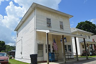
Russellville is a town in Russell Township, Putnam County, in the U.S. state of Indiana. The population was 358 at the 2010 census.

<span class="mw-page-title-main">Russellville, Missouri</span> City in Missouri, United States

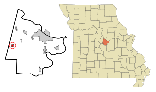
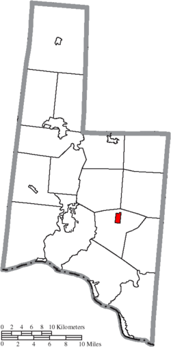
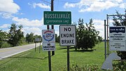
Russellville is a city in Cole County, Missouri, United States. The population was 778 at the 2020 census. It is part of the Jefferson City, Missouri Metropolitan Statistical Area.

<span class="mw-page-title-main">Warsaw, Ohio</span> Village in Ohio, United States

Warsaw is a village in Coshocton County, Ohio, United States, along the Walhonding River. The population was 624 at the 2020 census.

<span class="mw-page-title-main">Castine, Ohio</span> Village in Ohio, United States

Castine is a village in Darke County, Ohio, United States. The population was 110 at the 2020 census.

<span class="mw-page-title-main">Ithaca, Ohio</span> Village in Ohio, United States

Ithaca is a village in Darke County, Ohio, United States. The population was 81 at the 2020 census.

<span class="mw-page-title-main">Pleasant City, Ohio</span> Village in Ohio, United States

Pleasant City is a village in Guernsey County, Ohio, United States. The population was 400 at the 2020 census.

<span class="mw-page-title-main">Addyston, Ohio</span> Village in Ohio, United States

Addyston is a village in Miami Township, Hamilton County, Ohio, United States. Located along the Ohio River, it is a western suburb of the neighboring city of Cincinnati. The population was 927 at the 2020 census.

<span class="mw-page-title-main">Cleves, Ohio</span> City in Ohio, United States

Cleves is a village in Miami Township, Hamilton County, Ohio, United States. Located along the Ohio River, it is a western suburb of Cincinnati. The population was 3,414 at the 2020 census.

<span class="mw-page-title-main">Evendale, Ohio</span> Village in Ohio, United States

Evendale is a village in Hamilton County, Ohio, United States, within the Cincinnati metropolitan area. The population was 2,669 at the 2020 census.

<span class="mw-page-title-main">Mowrystown, Ohio</span> Village in Ohio, United States

Mowrystown is a village in Highland County, Ohio, United States. The population was 385 at the 2020 census.

<span class="mw-page-title-main">Hanover, Ohio</span> Village in Ohio, United States

Hanover is a village in Licking County, Ohio, United States. The population was 1,270 at the 2020 census. The village lies along Ohio State Route 16.

<span class="mw-page-title-main">St. Louisville, Ohio</span> Village in Ohio, United States

St. Louisville or Saint Louisville is a village in Licking County, Ohio, United States, along the North Fork of the Licking River. The population was 352 at the 2020 census.

<span class="mw-page-title-main">Chesterville, Ohio</span> Village in Ohio, United States

Chesterville is a village in Morrow County, Ohio, United States, along the Kokosing River. The population was 191 at the 2020 census. Chesterville is southeast of Mount Gilead, the county seat.

<span class="mw-page-title-main">Tarlton, Ohio</span> Village in Ohio, United States

Tarlton is a village in Fairfield and Pickaway counties in the U.S. state of Ohio. The population was 254 at the 2020 census.

<span class="mw-page-title-main">Cloverdale, Ohio</span> Village in Ohio, United States

Cloverdale is a village in Perry Township, Putnam County, Ohio, United States. The population was 170 at the 2020 census.

<span class="mw-page-title-main">Limaville, Ohio</span> Census-designated place in Ohio, United States

Limaville is a census-designated place (CDP) and former village in Stark County, Ohio, United States. The population was 151 at the 2020 census. It is part of the Canton–Massillon Metropolitan Statistical Area.

<span class="mw-page-title-main">Macksburg, Ohio</span> Village in Ohio, United States

Macksburg is a village in Washington County, Ohio, United States, along the West Fork of Duck Creek. The population was 120 at the 2020 census. The village is about 28 miles (45 km) south of Cambridge, Ohio.

<span class="mw-page-title-main">Verona, Ohio</span> Village in Ohio, United States

Verona is a village in Montgomery and Preble counties in the U.S. state of Ohio. The population was 403 at the 2020 census. It is part of the Dayton Metropolitan Statistical Area.

References

  1. "ArcGIS REST Services Directory". United States Census Bureau. Retrieved September 20, 2022.
  2. 1 2 U.S. Geological Survey Geographic Names Information System: Russellville, Ohio
  3. 1 2 "U.S. Census website". United States Census Bureau . Retrieved January 31, 2008.
  4. The History of Brown County, Ohio. Higginson Book Company. 1883. pp.  620.
  5. "US Gazetteer files 2010". United States Census Bureau. Archived from the original on January 25, 2012. Retrieved January 6, 2013.
  6. "Census of Population and Housing". Census.gov. Retrieved June 4, 2015.
  7. "U.S. Census website". United States Census Bureau . Retrieved January 6, 2013.