Ripley, Ohio

Last updated

Ripley, Ohio
RipleyOH2.JPG
Looking north on Second Street (U.S. Route 52) in Ripley
Motto: 
"Freedoms Landing - Where thousands found freedom on the Underground Railroad"
OHMap-doton-Ripley.png
Location of Ripley, Ohio
Map of Brown County Ohio Highlighting Ripley Village.png
Location of Ripley in Brown County
Coordinates: 38°44′22″N83°50′18″W / 38.73944°N 83.83833°W / 38.73944; -83.83833
Country United States
State Ohio
County Brown
Township Union
Named for Eleazer Wheelock Ripley
Area
[1]
  Total2.29 sq mi (5.94 km2)
  Land1.99 sq mi (5.15 km2)
  Water0.31 sq mi (0.79 km2)
Elevation
[2]
535 ft (163 m)
Population
 (2020)
  Total1,591
  Density799.90/sq mi (308.88/km2)
Time zone UTC-5 (Eastern (EST))
  Summer (DST) UTC-4 (EDT)
ZIP code
45167
Area code(s) 937, 326
FIPS code 39-67272 [3]
GNIS feature ID2399079 [2]
Website villageofripley.com

Ripley is a village in Union Township, Brown County, Ohio, United States, along the Ohio River 50 miles southeast of Cincinnati. The population was 1,591 at the 2020 census.

Contents

History

Colonel James Poage, a veteran of the American Revolution, arrived in the free state of Ohio from Staunton, Virginia in 1804 to claim the 1,000 acres (4.0 km2) he had been granted in what was called the Virginia Military District. Poage was among a large group of veterans who received land grants in what was first organized as the Northwest Territory north of the Ohio River for their service in the American Revolutionary War, and freed their slaves when they settled there. Poage and his family laid out the town of Staunton in 1812; it was renamed in 1816 to honor General Eleazar Wheelock Ripley, [4] an American officer of the War of 1812.

Given its location on the river, Ripley became a destination for slaves escaping from slavery in Kentucky on the other side. Both black and white residents developed a network, making Ripley an early stop on the Underground Railroad, to help slaves escape north to freedom. A number of prominent abolitionists lived in the town in the 19th century, mainly on Front Street near the river. John Rankin moved from Kentucky to Ripley in 1822 and later built a house on Liberty Hill overlooking the town, the river, and the Kentucky shore. From there, he signaled escaping slaves with a lantern on a flagpole [5] and provided them shelter. The house is now known as the John Rankin House, and has been designated as a National Historic Landmark. Rankin was also the minister at the Ripley Presbyterian Church for twenty-four years.

Geography

The town is surrounded by steep, rolling hills on the northeast, Red Oak Creek on the southeast, and the Ohio River on the southwest.

According to the United States Census Bureau, the village has a total area of 2.30 square miles (5.96 km2), of which 1.99 square miles (5.15 km2) is land and 0.31 square miles (0.80 km2) is water. [6]

Demographics

Historical population
CensusPop.Note
1820 421
1830 57235.9%
1840 81642.7%
1850 1,780118.1%
1860 2,71552.5%
1870 2,323−14.4%
1880 2,5469.6%
1890 2,483−2.5%
1900 2,248−9.5%
1910 1,840−18.1%
1920 1,529−16.9%
1930 1,5561.8%
1940 1,6234.3%
1950 1,79210.4%
1960 2,17421.3%
1970 2,74526.3%
1980 2,174−20.8%
1990 1,816−16.5%
2000 1,745−3.9%
2010 1,7500.3%
2020 1,591−9.1%
U.S. Decennial Census [7]

2010 census

As of the census [8] of 2010, there were 1,750 people, 759 households, and 469 families living in the village. The population density was 879.4 inhabitants per square mile (339.5/km2). There were 931 housing units at an average density of 467.8 per square mile (180.6/km2). The racial makeup of the village was 92.6% White, 4.9% African American, 0.2% Native American, 0.2% Asian, and 2.2% from two or more races. Hispanic or Latino of any race were 0.5% of the population.

There were 759 households, of which 30.3% had children under the age of 18 living with them, 40.2% were married couples living together, 16.5% had a female householder with no husband present, 5.1% had a male householder with no wife present, and 38.2% were non-families. 32.5% of all households were made up of individuals, and 12.8% had someone living alone who was 65 years of age or older. The average household size was 2.31 and the average family size was 2.91.

The median age in the village was 42.2 years. 24.1% of residents were under the age of 18; 6.9% were between the ages of 18 and 24; 22.8% were from 25 to 44; 30% were from 45 to 64; and 15.9% were 65 years of age or older. The gender makeup of the village was 47.5% male and 52.5% female.

2000 census

As of the census [3] of 2000, there were 1,745 people, 745 households, and 467 families living in the village. The population density was 1,722.2 inhabitants per square mile (664.9/km2). There were 896 housing units at an average density of 884.3 per square mile (341.4/km2). The racial makeup of the village was 91.69% White, 6.65% African American, 0.06% Native American, 0.17% Asian, 0.17% from other races, and 1.26% from two or more races. Hispanic or Latino of any race were 0.69% of the population.

There were 745 households, out of which 28.9% had children under the age of 18 living with them, 44.0% were married couples living together, 16.2% had a female householder with no husband present, and 37.2% were non-families. 32.8% of all households were made up of individuals, and 16.9% had someone living alone who was 65 years of age or older. The average household size was 2.34 and the average family size was 2.97.

In the village, the population was spread out, with 24.9% under the age of 18, 9.2% from 18 to 24, 26.3% from 25 to 44, 21.9% from 45 to 64, and 17.8% who were 65 years of age or older. The median age was 38 years. For every 100 females, there were 83.1 males. For every 100 females age 18 and over, there were 79.8 males.

The median income for a household in the village was $30,000, and the median income for a family was $39,330. Males had a median income of $29,318 versus $20,977 for females. The per capita income for the village was $15,268. About 11.7% of families and 15.5% of the population were below the poverty line, including 21.9% of those under age 18 and 15.7% of those age 65 or over.

Notable people

See also

Related Research Articles

<span class="mw-page-title-main">Aberdeen, Ohio</span> Village in Ohio, United States

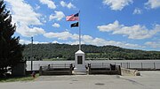
Aberdeen is a village in Huntington Township, Brown County, Ohio, United States, along the Ohio River 50 miles (80 km) southeast of Cincinnati. The population was 1,515 at the 2020 census.

<span class="mw-page-title-main">Mechanicsburg, Ohio</span> Village in Ohio, United States

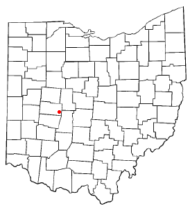
Mechanicsburg is a village in Champaign County, Ohio, United States. The population was 1,681 at the 2020 census.

<span class="mw-page-title-main">Hanoverton, Ohio</span> Village in Ohio, United States

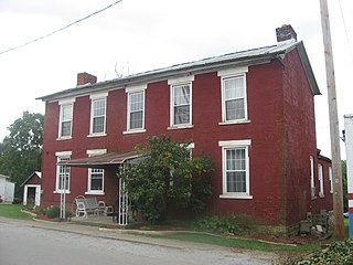
Hanoverton is a village in western Columbiana County, Ohio, United States. The population was 354 at the 2020 census. It is part of the Salem micropolitan area, 23 miles (37 km) miles east of Canton and 28 miles (45 km) southwest of Youngstown.

<span class="mw-page-title-main">Warsaw, Ohio</span> Village in Ohio, United States

Warsaw is a village in Coshocton County, Ohio, United States, along the Walhonding River. The population was 624 at the 2020 census.

<span class="mw-page-title-main">Rushville, Ohio</span> Village in Ohio, United States

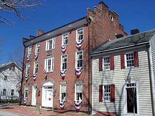
Rushville is a village in Fairfield County, Ohio, United States. The population was 304 at the 2020 census. Much of the village is listed on the National Register of Historic Places as the Rushville Historic District.

<span class="mw-page-title-main">Vinton, Ohio</span> Village in Ohio, United States

Vinton is a village in Gallia County, Ohio, United States. The population was 224 at the 2020 census. It is part of the rural Point Pleasant micropolitan area.

<span class="mw-page-title-main">Addyston, Ohio</span> Village in Ohio, United States

Addyston is a village in Miami Township, Hamilton County, Ohio, United States. Located along the Ohio River, it is a western suburb of the neighboring city of Cincinnati. The population was 927 at the 2020 census.

<span class="mw-page-title-main">Cleves, Ohio</span> City in Ohio, United States

Cleves is a village in Miami Township, Hamilton County, Ohio, United States. Located along the Ohio River, it is a western suburb of Cincinnati. The population was 3,414 at the 2020 census.

<span class="mw-page-title-main">Evendale, Ohio</span> Village in Ohio, United States

Evendale is a village in Hamilton County, Ohio, United States, within the Cincinnati metropolitan area. The population was 2,669 at the 2020 census.

<span class="mw-page-title-main">North Bend, Ohio</span> Village in Ohio, United States

North Bend is a village in Miami Township, Hamilton County, Ohio, United States, along the Ohio River. It is a part of the Greater Cincinnati area. The population was 835 at the 2020 census.

<span class="mw-page-title-main">New Athens, Ohio</span> Village in Ohio, United States

New Athens is a village in Harrison County, Ohio, United States. The population was 222 at the 2020 census.

<span class="mw-page-title-main">Mount Pleasant, Ohio</span> Village in Ohio, United States

Mount Pleasant is a village in southern Jefferson County, Ohio, United States. The population was 394 at the 2020 census. It is part of the Weirton–Steubenville metropolitan area. Founded in 1803 by anti-slavery Quakers, the village was an early center of abolitionist activity and a well-known haven for fugitive slaves on the Underground Railroad.

<span class="mw-page-title-main">Rayland, Ohio</span> Village in Ohio, United States

Rayland is a village in southern Jefferson County, Ohio, United States, along the Ohio River. The population was 389 at the 2020 census. It is part of the Weirton–Steubenville metropolitan area.

<span class="mw-page-title-main">Stratton, Ohio</span> Village in Ohio, United States

Stratton is a village in northern Jefferson County, Ohio, United States, along the Ohio River. The population was 267 at the 2020 census. It is part of the Weirton–Steubenville metropolitan area.

<span class="mw-page-title-main">Gann, Ohio</span> Village in Ohio, United States

Brinkhaven, once known as Mount Holly and Gann, is a village in Knox County, Ohio, United States. The population was 114 at the 2020 census.

<span class="mw-page-title-main">Madison, Ohio</span> Village in Ohio, United States

Madison is a village in Lake County, Ohio, United States. The population was 3,435 at the 2020 census.

<span class="mw-page-title-main">Stafford, Ohio</span> Village in Ohio, United States

Stafford is a village in Monroe County, Ohio, United States. The population was 71 at the 2020 census.

<span class="mw-page-title-main">Harveysburg, Ohio</span> Village in Ohio, United States

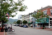
Harveysburg is a village in Massie Township, Warren County, Ohio, United States. The population was 554 at the 2020 census. It is best known as the home of the Ohio Renaissance Festival.

<span class="mw-page-title-main">Yorkville, Ohio</span> Village in Ohio, United States

Yorkville is a village in Belmont and Jefferson counties in the U.S. state of Ohio. The population was 968 at the 2020 census. Yorkville lies within two Metropolitan Statistical Areas; the Belmont County portion is part of the Wheeling metropolitan area, while the Jefferson County portion is part of the Weirton–Steubenville metropolitan area.

<span class="mw-page-title-main">Winchester, Adams County, Ohio</span> Village in Ohio, United States

Winchester is a village in Adams County, Ohio, United States. The population was 987 at the 2020 census. The name of the surrounding township is also named Winchester.

References

  1. "ArcGIS REST Services Directory". United States Census Bureau. Retrieved September 20, 2022.
  2. 1 2 U.S. Geological Survey Geographic Names Information System: Ripley, Ohio
  3. 1 2 "U.S. Census website". United States Census Bureau . Retrieved January 31, 2008.
  4. The History of Brown County, Ohio: Containing a History of the County, Its Townships, Towns, Churches, Schools, Etc. Higginson Book Company. 1883. pp.  416.
  5. "African Americans in Ohio".
  6. "US Gazetteer files 2010". United States Census Bureau. Archived from the original on January 25, 2012. Retrieved January 6, 2013.
  7. "Census of Population and Housing". Census.gov. Retrieved June 4, 2015.
  8. "U.S. Census website". United States Census Bureau . Retrieved January 6, 2013.