Pawnee, Texas

Last updated

Pawnee, Texas
TXMap-doton-Pawnee.PNG
Location of Pawnee, Texas
Bee Pawnee.svg
Coordinates: 28°38′58″N98°0′6″W / 28.64944°N 98.00167°W / 28.64944; -98.00167
Country United States
State Texas
County Bee
Area
  Total5.3 sq mi (13.6 km2)
  Land5.3 sq mi (13.6 km2)
  Water0.0 sq mi (0.0 km2)
Elevation
384 ft (117 m)
Population
 (2020)
  Total140
  Density27/sq mi (10/km2)
Time zone UTC-6 (Central (CST))
  Summer (DST) UTC-5 (CDT)
ZIP code
78145
Area code 361
FIPS code 48-56252 [1]
GNIS feature ID1364905 [2]

Pawnee is a census-designated place (CDP) in Bee County, Texas, United States. The population was 140 at the 2020 census.

Contents

Geography

Pawnee is located in northwestern Bee County at 28°38′58″N98°0′6″W / 28.64944°N 98.00167°W / 28.64944; -98.00167 (28.649307, -98.001649). [3] Texas State Highway 72 runs through the community, leading northeastward 15 miles (24 km) to Kenedy and southwestward 14 miles (23 km) to Interstate 37, near Three Rivers.

According to the United States Census Bureau, the CDP has a total area of 5.3 square miles (13.6 km2), all land. [4]

Attractions

Pawnee is known for its excellent dove, quail, and white tail deer hunting.

Demographics

Historical population
CensusPop.Note
2000 201
2010 166−17.4%
2020 140−15.7%
US Decennial Census [3]
2020 Census [5]

As of the census [1] of 2000, there were 201 people, 75 households, and 54 families residing in the CDP. The population density was 38.5 people per square mile (14.9 people/km2). There were 93 housing units at an average density of 17.8 per square mile (6.9/km2). The racial makeup of the CDP was 58.21% White, 0.50% African American, 41.29% from other races. Hispanic or Latino of any race were 90.05% of the population.

There were 75 households, out of which 29.3% had children under the age of 18 living with them, 66.7% were married couples living together, 1.3% had a female householder with no husband present, and 28.0% were non-families. 24.0% of all households were made up of individuals, and 16.0% had someone living alone who was 65 years of age or older. The average household size was 2.68 and the average family size was 3.28.

In the CDP, the population was spread out, with 23.9% under the age of 18, 8.5% from 18 to 24, 26.9% from 25 to 44, 21.9% from 45 to 64, and 18.9% who were 65 years of age or older. The median age was 38 years. For every 100 females, there were 109.4 males. For every 100 females age 18 and over, there were 109.6 males.

The median income for a household in the CDP was $35,500, and the median income for a family was $57,000. Males had a median income of $46,042 versus $37,125 for females. The per capita income for the CDP was $21,165. About 17.0% of families and 19.9% of the population were below the poverty line, including 26.7% of those under the age of eighteen and 35.8% of those 65 or over.

Education

Pawnee is served by the Pawnee Independent School District for grades preK-8.

Area information

The small town consists of one convenience store, a US post office, an Independent School District, a mechanic service, a natural gas plant, a cabinet maker, a volunteer fire department, an excavation company, a community center, and several churches.

The Pawnee area has gradually been increasing in the exploration and production of natural gas. Just driving around the community and ranches, you can see wells and new rigs going up.

Pawnee has more recently welcomed Almega Cable and Ranch Wireless to the community. Ranch Wireless provides wireless internet and Almega Cable provides Cable internet to the citizens of Pawnee. Almega has also established a computer center for the community to access the internet free of cost. The center is called the Pawnee Community Connect Center.

Religion

The small community boasts five churches. The churches are Catholic, Methodist, Baptist, Iglesia Bautista Y Manuela, and Church of Christ.

Related Research Articles

<span class="mw-page-title-main">Foothill Ranch, California</span> Human settlement in California, United States of America

Foothill Ranch is a neighborhood of the city of Lake Forest in Orange County, California, United States. The population was 10,899 at the 2000 census. The master planned community was a census-designated place prior to being incorporated into the city in 2000.

<span class="mw-page-title-main">West Yarmouth, Massachusetts</span> Census-designated place in Massachusetts, United States

West Yarmouth is a census-designated place (CDP) in the town of Yarmouth in Barnstable County, Massachusetts, United States. The population was 6,012 at the 2010 census.

<span class="mw-page-title-main">Tuleta, Texas</span> Census-designated place in Texas, United States

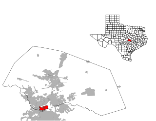
Tuleta is a census-designated place (CDP) in Bee County, Texas, United States. The population was 231 at the 2020 census.

<span class="mw-page-title-main">Arroyo Colorado Estates, Texas</span> CDP in Texas, United States

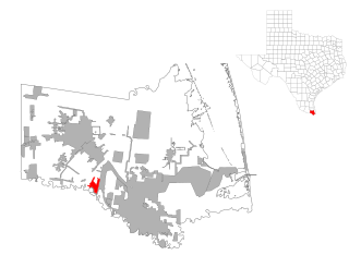
Arroyo Colorado Estates is a census-designated place (CDP) in Cameron County, in the U.S. state of Texas. The population was 997 at the 2010 census. It is part of the Brownsville–Harlingen Metropolitan Statistical Area.

<span class="mw-page-title-main">Encantada-Ranchito-El Calaboz, Texas</span> Census-designated place in Texas, United States

Encantada-Ranchito-El Calaboz, also known as El Calaboz Rancheria in the San Pedro de Carricitos Land Grant, is a census-designated place (CDP) in Cameron County, Texas, United States. The population was 1,981 at the 2020 census. It is part of the Brownsville–Harlingen Metropolitan Statistical Area.

<span class="mw-page-title-main">Concepcion, Texas</span> Census-designated place in Texas, United States

Concepcion is an unincorporated community and census-designated place (CDP) in Duval County, Texas, United States. The population was 62 at the 2010 census.

<span class="mw-page-title-main">Laguna Seca, Texas</span> Census-designated place in Texas

Laguna Seca is a census-designated place (CDP) in Hidalgo County, Texas, United States. The population was 232 at the 2020 United States Census. It is part of the McAllen–Edinburg–Mission Metropolitan Statistical Area.

<span class="mw-page-title-main">Los Ebanos, Hidalgo County, Texas</span> Census-designated place in Texas

Los Ebanos is a census-designated place (CDP) in Hidalgo County, Texas, United States. The population was 239 at the 2020 United States Census. It is part of the McAllen–Edinburg–Mission Metropolitan Statistical Area. The city is named after the Texas Ebony that anchors the Los Ebanos Ferry.

<span class="mw-page-title-main">Muniz, Texas</span> Census-designated place in Texas

Muniz is a census-designated place (CDP) in Hidalgo County, Texas, United States. The population was 1,593 at the 2020 United States Census. It is part of the McAllen–Edinburg–Mission Metropolitan Statistical Area.

<span class="mw-page-title-main">Relampago, Texas</span> Census-designated place in Texas

Relampago is a census-designated place (CDP) in Hidalgo County, Texas, United States. The population was 129 at the 2020 United States Census. It is part of the McAllen–Edinburg–Mission Metropolitan Statistical Area.

<span class="mw-page-title-main">South Alamo, Texas</span> Census-designated place in Texas

South Alamo is a census-designated place (CDP) in Hidalgo County, Texas, United States. The area is known locally as "Little Mex (Mexico)". The population was 3,414 at the 2020 United States Census. It is part of the McAllen–Edinburg–Mission Metropolitan Statistical Area.

<span class="mw-page-title-main">K-Bar Ranch, Texas</span> Census-designated place in Texas, United States

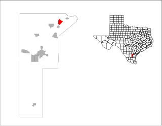
K-Bar Ranch is a census-designated place (CDP) in Jim Wells County, Texas, United States. The population was 375 at the 2020 census.

<span class="mw-page-title-main">Owl Ranch-Amargosa, Texas</span> CDP in Texas, United States

Owl Ranch-Amargosa is a census-designated place (CDP) in Jim Wells County, Texas, United States. The population was 527 at the 2000 census. The area is widely referred to as "Tecolote", the Spanish term for "owl".

<span class="mw-page-title-main">Sandia, Texas</span> Census-designated place in Texas, United States

Sandia is an unincorporated community and census-designated place (CDP) in Jim Wells County, Texas, United States. The population was 326 at the 2020 census, down from 379 at the 2010 census.

<span class="mw-page-title-main">Spade, Texas</span> Unincorporated community in Texas, US

Spade is an unincorporated community and census-designated place (CDP) in Lamb County, Texas, United States. The population was 73 at the 2010 census.

<span class="mw-page-title-main">Kingsland, Texas</span> Census-designated place in Texas, United States

Kingsland is a census-designated place (CDP) in Llano County, Texas, United States. The population was 6,030 at the 2010 census, up from 4,584 at the 2000 census. Texas Ranch to Market Road 1431 runs through the community.

<span class="mw-page-title-main">El Refugio, Texas</span> CDP in Texas, United States

El Refugio is a census-designated place (CDP) in Starr County, Texas, United States. The population was 407 at the 2020 census. El Refugio gained area in the 2010 census.

<span class="mw-page-title-main">Bruni, Texas</span> CDP in Texas, United States

Bruni is a census-designated place (CDP) in Webb County, Texas, United States. The population was 379 at the 2010 census.

<span class="mw-page-title-main">Zapata Ranch, Texas</span> CDP in Texas, United States

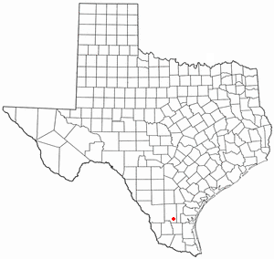
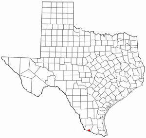
Zapata Ranch is a census-designated place (CDP) in Willacy County, Texas, United States. The population was 87 at the 2020 census.

<span class="mw-page-title-main">Jollyville, Texas</span> Place in Texas, United States

Jollyville is a neighborhood in the northern part of Austin, Texas, United States. In 2010 it was a census-designated place (CDP) in Travis and Williamson counties, but has since been annexed by Austin. The population of the CDP was 16,151 at the 2010 census.

References

  1. 1 2 "U.S. Census website". United States Census Bureau . Retrieved January 31, 2008.
  2. "US Board on Geographic Names". United States Geological Survey. October 25, 2007. Retrieved January 31, 2008.
  3. 1 2 "US Gazetteer files: 2010, 2000, and 1990". United States Census Bureau. February 12, 2011. Retrieved April 23, 2011.
  4. "Geographic Identifiers: 2010 Demographic Profile Data (G001): Pawnee CDP, Texas". U.S. Census Bureau, American Factfinder. Retrieved April 10, 2014.
  5. "Census Bureau profile: Pawnee, Texas". United States Census Bureau. May 2023. Retrieved May 27, 2024.