Pilot Mound, Iowa

Last updated

Pilot Mound, Iowa
Boone County Iowa Incorporated and Unincorporated areas Pilot Mound Highlighted.svg
Location of Pilot Mound, Iowa
Coordinates: 42°9′45″N94°0′52″W / 42.16250°N 94.01444°W / 42.16250; -94.01444
Country Flag of the United States.svg  United States
State Flag of Iowa.svg  Iowa
County Boone
Township Pilot Mound
Area
[1]
  Total0.98 sq mi (2.54 km2)
  Land0.98 sq mi (2.54 km2)
  Water0.00 sq mi (0.00 km2)
Elevation
1,109 ft (338 m)
Population
 (2020)
  Total163
  Density165.99/sq mi (64.06/km2)
Time zone UTC-6 (Central (CST))
  Summer (DST) UTC-5 (CDT)
ZIP code
50223
Area code 515
FIPS code 19-62850
GNIS feature ID0460155
Website https://pilotmound.org

Pilot Mound is a city in Pilot Mound Township, Boone County, Iowa, United States. The population was 163 at the time of the 2020 census. [2] It is part of the Boone, Iowa Micropolitan Statistical Area, which is a part of the larger Ames-Boone, Iowa Combined Statistical Area.

Contents

History

A post office called Pilot Mound has been in operation since 1865. [3] The post office antedates the town's existence. [4] Pilot Mound was laid out as a town in 1881. [5] The community took its name from a prominent summit which affords a clear view of the surrounding area. [6]

Geography

Pilot Mound is located at 42°9′45″N94°0′52″W / 42.16250°N 94.01444°W / 42.16250; -94.01444 (42.162554, -94.014372). [7]

According to the United States Census Bureau, the city has a total area of 0.98 square miles (2.54 km2), all land. [8] Bluff Creek flows near the town site. [6]

Demographics

Historical populations
YearPop.±%
1900 315    
1910 347+10.2%
1920 311−10.4%
1930 274−11.9%
1940 282+2.9%
1950 246−12.8%
1960 196−20.3%
1970 214+9.2%
1980 223+4.2%
1990 199−10.8%
2000 214+7.5%
2010 173−19.2%
2020 163−5.8%
Source: "U.S. Census website". United States Census Bureau . Retrieved March 29, 2020. and Iowa Data Center
Source:
U.S. Decennial Census [9] [2]

2010 census

As of the census [10] of 2010, there were 173 people, 83 households, and 47 families living in the city. The population density was 176.5 inhabitants per square mile (68.1/km2). There were 99 housing units at an average density of 101.0 per square mile (39.0/km2). The racial makeup of the city was 96.0% White, 2.3% African American, 0.6% Native American, and 1.2% from two or more races.

There were 83 households, of which 20.5% had children under the age of 18 living with them, 47.0% were married couples living together, 3.6% had a female householder with no husband present, 6.0% had a male householder with no wife present, and 43.4% were non-families. 36.1% of all households were made up of individuals, and 18% had someone living alone who was 65 years of age or older. The average household size was 2.08 and the average family size was 2.68.

The median age in the city was 51.9 years. 15% of residents were under the age of 18; 7.4% were between the ages of 18 and 24; 18.6% were from 25 to 44; 34.1% were from 45 to 64; and 24.9% were 65 years of age or older. The gender makeup of the city was 52.6% male and 47.4% female.

2000 census

As of the census [11] of 2000, there were 214 people, 96 households, and 55 families living in the city. The population density was 225.6 inhabitants per square mile (87.1/km2). There were 102 housing units at an average density of 107.5 per square mile (41.5/km2). The racial makeup of the city was 99.53% White and 0.47% Native American.

There were 96 households, out of which 21.9% had children under the age of 18 living with them, 47.9% were married couples living together, 3.1% had a female householder with no husband present, and 41.7% were non-families. 35.4% of all households were made up of individuals, and 21.9% had someone living alone who was 65 years of age or older. The average household size was 2.23 and the average family size was 2.79.

In the city, the population was spread out, with 20.1% under the age of 18, 6.1% from 18 to 24, 22.9% from 25 to 44, 30.4% from 45 to 64, and 20.6% who were 65 years of age or older. The median age was 46 years. For every 100 females, there were 120.6 males. For every 100 females age 18 and over, there were 98.8 males.

The median income for a household in the city was $29,750, and the median income for a family was $35,313. Males had a median income of $28,125 versus $22,031 for females. The per capita income for the city was $14,414. About 4.9% of families and 8.5% of the population were below the poverty line, including none of those under the age of eighteen and 14.5% of those 65 or over.

Education

It is in the Southeast Valley Community School District. [12] Southeast Valley High School in Gowrie is that district's comprehensive high school.

Pilot Mound was a part of the Southeast Webster-Grand Community School District, [13] established on July 1, 2005 by the merger of the Grand Community School District and the Southeast Webster Community School District. [14] In 2023 the Southeast Webster-Grand district merged into the Southeast Valley district. [15]

Related Research Articles

<span class="mw-page-title-main">Wright County, Iowa</span> County in Iowa, United States

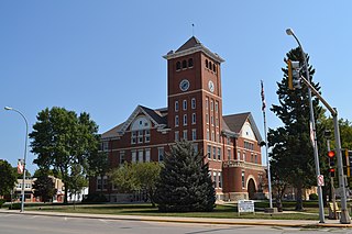
Wright County is a county in the U.S. state of Iowa. As of the 2020 census, the population was 12,943. The county seat is Clarion. The county organization became effective in January 1851, and is believed to be named either after Silas Wright, a governor of New York, or Joseph Albert Wright, a governor of Indiana.

<span class="mw-page-title-main">Polk County, Iowa</span> County in Iowa, United States

Polk County is located in the U.S. state of Iowa. As of the 2020 census, the population was 492,401. It is Iowa's most populous county, and home to over 15% of the state's residents. The county seat is Des Moines, which is also the capital city of Iowa. Polk County is included in the Des Moines–West Des Moines, IA Metropolitan Statistical Area.

<span class="mw-page-title-main">Hamilton County, Iowa</span> County in Iowa, United States

Hamilton County is a county located in the U.S. state of Iowa. As of the 2020 census, the population was 15,039. The county seat is Webster City. The county was named to honor William W. Hamilton, a President of the Iowa State Senate.

<span class="mw-page-title-main">Boone County, Iowa</span> County in Iowa, United States

Boone County is a county in the U.S. state of Iowa. As of the 2020 census, the population was 26,715. Its county seat is Boone.

<span class="mw-page-title-main">Berkley, Iowa</span> City in Iowa, United States

Berkley is a city in Union Township, Boone County, Iowa, United States. The population was 23 at the 2020 census, down 4.2% from 24 in 2000.

<span class="mw-page-title-main">Boxholm, Iowa</span> City in Iowa, United States

Boxholm is a city in Grant Township, Boone County, Iowa, United States. The population was 181 at the 2020 census. It is part of the Boone, Iowa Micropolitan Statistical Area, which is a part of the larger Ames-Boone, Iowa Combined Statistical Area.

<span class="mw-page-title-main">Fraser, Iowa</span> City in Iowa, United States

Fraser is a city in Dodge Township, Boone County, Iowa, United States. The population was 101 at the time of the 2020 census. It is part of the Boone, Iowa Micropolitan Statistical Area, which is a part of the larger Ames–Boone Combined Statistical Area. The city is located along the Des Moines River.

<span class="mw-page-title-main">Farnhamville, Iowa</span> City in Iowa, United States

Farnhamville is a city in Calhoun and Webster counties in the U.S. state of Iowa. The population was 383 at the time of the 2020 census.

<span class="mw-page-title-main">Manson, Iowa</span> City in Iowa, United States

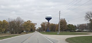
Manson is a city in Calhoun County, Iowa, United States. The population was 1,709 at the time of the 2020 census.

<span class="mw-page-title-main">Rinard, Iowa</span> City in Iowa, United States

Rinard is a city in Calhoun County, Iowa, United States. The population was 38 at the time of the 2020 census.

<span class="mw-page-title-main">Somers, Iowa</span> City in Iowa, United States

Somers is a city in Calhoun County, Iowa, United States. The population was 128 at the time of the 2020 census.

<span class="mw-page-title-main">Grand Mound, Iowa</span> City in Iowa, United States

Grand Mound is a city in Clinton County, Iowa, United States. The population was 615 at the time of the 2020 census.

<span class="mw-page-title-main">Renwick, Iowa</span> City in Iowa, United States

Renwick is a city in Humboldt County, Iowa, United States. The population was 234 at the time of the 2020 census.

<span class="mw-page-title-main">Callender, Iowa</span> City in Iowa, United States

Callender is a city in Webster County, Iowa, United States. The population was 368 at the time of the 2020 census.

<span class="mw-page-title-main">Dayton, Iowa</span> City in Iowa, United States

Dayton is a city in Webster County, Iowa, United States. The population was 772 at the time of the 2020 census.

<span class="mw-page-title-main">Gowrie, Iowa</span> City in Iowa, United States

Gowrie is a city in Webster County, Iowa, United States. The population was 952 at the time of the 2020 census. The town has a swimming pool, golf course, athletic stadium, and curb-and-gutter throughout the community.

<span class="mw-page-title-main">Harcourt, Iowa</span> City in Iowa, United States

Harcourt is a city in Webster County, Iowa, United States. The population was 264 at the time of the 2020 census.

<span class="mw-page-title-main">Lehigh, Iowa</span> City in Iowa, United States

Lehigh is a city in Webster County, Iowa, United States. The population was 395 at the time of the 2020 census.

<span class="mw-page-title-main">Moorland, Iowa</span> City in Iowa, United States

Moorland is a small town in Webster County, Iowa, United States. The population was 168 at the time of the 2020 census.

<span class="mw-page-title-main">Eagle Grove, Iowa</span> City in Iowa, United States

Eagle Grove is a city in Wright County, Iowa, United States. The population was 3,601 at the time of the 2020 census. Eagle Grove is the largest city in Wright County.

References

  1. "2020 U.S. Gazetteer Files". United States Census Bureau. Retrieved March 16, 2022.
  2. 1 2 "2020 Census State Redistricting Data". census.gov. United states Census Bureau. Retrieved August 12, 2021.
  3. "County History". Boone County. Archived from the original on June 12, 2017. Retrieved March 24, 2018.
  4. "Post Offices". Jim Forte Postal History. Retrieved March 24, 2018.
  5. Goldthwait, Nathan Edward (1914). History of Boone County, Iowa, Volume 1. Pioneer Publishing Company. p. 279.
  6. 1 2 Goldthwait, Nathan Edward (1914). History of Boone County, Iowa. Pioneer Publishing Company. p.  86.
  7. "US Gazetteer files: 2010, 2000, and 1990". United States Census Bureau. February 12, 2011. Retrieved April 23, 2011.
  8. "US Gazetteer files 2010". United States Census Bureau. Archived from the original on July 2, 2012. Retrieved May 11, 2012.
  9. "Census of Population and Housing". Census.gov. Retrieved June 4, 2015.
  10. "U.S. Census website". United States Census Bureau . Retrieved May 11, 2012.
  11. "U.S. Census website". United States Census Bureau . Retrieved January 31, 2008.
  12. "SOUTHEAST VALLEY 2022-2023" (PDF). Iowa Department of Education . Retrieved November 11, 2023.
  13. "Southeast Webster-Grand." Iowa Department of Education. Retrieved on February 24, 2019.
  14. "REORGANIZATION & DISSOLUTION ACTIONS SINCE 1965-66 Archived 2019-02-09 at the Wayback Machine ." Iowa Department of Education. Retrieved on February 23, 2019.
  15. Shea, Bill (June 30, 2023). "Southeast Valley to become official". The Messenger . Fort Dodge, Iowa . Retrieved November 11, 2023.