
Crater Lake is a volcanic crater lake in south-central Oregon in the Western United States. It is the main feature of Crater Lake National Park and is famous for its deep blue color and water clarity. The lake partly fills a 2,148-foot-deep (655 m) caldera that was formed around 7,700 years ago by the collapse of the volcano Mount Mazama. No rivers flow into or out of the lake; the evaporation is compensated for by rain and snowfall at a rate such that the total amount of water is replaced every 250 years. With a depth of 1,949 feet (594 m), the lake is the deepest in the United States. In the world, it ranks tenth for maximum depth, as well as third for mean (average) depth.
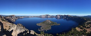
Crater Lake National Park is an American national park located in southern Oregon. Established in 1902, Crater Lake is the fifth-oldest national park in the United States and the only national park in Oregon. The park encompasses the caldera of Crater Lake, a remnant of Mount Mazama, a destroyed volcano, and the surrounding hills and forests.

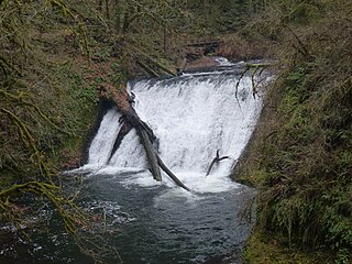
Barr Creek Falls, is a waterfall located in the Rogue River Canyon within the Prospect State Scenic Viewpoint in Jackson County, in the U.S. state of Oregon. The waterfall is located at the south end of Barr Creek as it plunges into the Rogue River over a carved cliff surrounded by walls of petrified volcanic ash as a consequence of the Mount Mazama eruption. The waterfall has also been called Bear Creek Falls. The waterfall gets its name from the creek which was called "Barr" for the presence of a fence that prevented cattle from straying out of the local Red Blanket Ranch and that ran adjacent to the creek.
The Volcanic Legacy Scenic Byway is a scenic highway and All-American Road in the U.S. states of California and Oregon. It is roughly 500 mi (804.7 km) long and travels north–south along the Cascade Range past numerous volcanoes. It is composed of two separate National Scenic Byways, the Volcanic Legacy Scenic Byway - Oregon and Volcanic Legacy Scenic Byway - California. The latter also wholly includes the Lassen Scenic Byway.

Mount Scott is a small stratovolcano and a so-called parasitic cone on the southeast flank of Crater Lake in southern Oregon. It is approximately 420,000 years old. Its summit is the highest point within Crater Lake National Park, and the tenth highest peak in the Oregon Cascades. A small fire lookout tower stands on the summit, at the end of a trail that zigzags approximately 1,500 feet up the mountain. The mountain is named for Oregon pioneer Levi Scott, founder of Scottsburg, Oregon.

Mill Creek Falls, is a waterfall located in the Rogue River Canyon within the Prospect State Scenic Viewpoint in Jackson County, in the U.S. state of Oregon. The waterfall is located at the south end of Mill Creek as it plunges into the Rogue River over a carved cliff surrounded by walls of petrified volcanic ash consequence of Mount Mazama eruption.

Rim Village is the main area for tourist services in Crater Lake National Park in southern Oregon, United States. It is located on the southwest rim of the caldera overlooking Crater Lake. The National Park Service designed Rim Village to concentrate park services at a location that provided easy access to rim trails and view points. Because of the unique rustic architecture of the Rim Village structures and the surrounding park landscape, the area was listed as Rim Village Historic District on the National Register of Historic Places in 1997.
Rim Drive is a scenic highway in Crater Lake National Park in southern Oregon, United States. It is a 33-mile (53 km) loop that follows the caldera rim around Crater Lake. Due to its unique engineering and the surrounding park landscape, the drive was listed as a historic district on the National Register of Historic Places in 2008.

South Falls, is a waterfall located in the Silver Falls State Park at the east end of the city of Salem, in Marion County, in the U.S. state of Oregon. It is located in a privileged area on the west foothills where Mount Hood National Forest meets with the Middle Santiam Wilderness. Several prominent waterfalls are located in the Park along Trail of Ten Falls: Lower South Falls, Drake Falls, Lower North Falls, and Winter Falls—among others.

Lower South Falls, is a waterfall located in the Silver Falls State Park at the east end of the city of Salem, in Marion County, in the U.S. state of Oregon. It is located in a privileged area on the west foothills where Mount Hood National Forest meets with the Middle Santiam Wilderness. Several prominent waterfalls are located in the Park along Trail of Ten Falls: South Falls, Drake Falls, Middle North Falls, and Winter Falls—among others.

Drake Falls, is a waterfall located in the Silver Falls State Park at the east end of the city of Salem, in Marion County, in the U.S. state of Oregon. It is located in a privileged area on the west foothills where Mount Hood National Forest meets with the Middle Santiam Wilderness. Several prominent waterfalls are located in the Park along Trail of Ten Falls: South Falls, Upper North Falls, Lower North Falls, and Winter Falls—among others.

Middle North Falls, is a waterfall located in the Silver Falls State Park at the east end of the city of Salem, in Marion County, in the U.S. state of Oregon. It is located in a privileged area on the west foothills where Mount Hood National Forest meets with the Middle Santiam Wilderness. Several prominent waterfalls are located in the Park along Trail of Ten Falls: South Falls, Lower South Falls, Drake Falls, and Lower North Falls—among others.

Winter Falls, is a waterfall located in the Silver Falls State Park at the east end of the city of Salem, in Marion County, in the U.S. state of Oregon. It is located in a privileged area on the west foothills where Mount Hood National Forest meets with the Middle Santiam Wilderness. Several prominent waterfalls are located in the Park along Trail of Ten Falls: South Falls, Lower South Falls, Lower North Falls, and Drake Falls—among others.
Lower North Falls, is a waterfall located in the Silver Falls State Park at the east end of the city of Salem, in Marion County, in the U.S. state of Oregon. It is located in a privileged area on the west foothills where Mount Hood National Forest meets with the Middle Santiam Wilderness. Several prominent waterfalls are located in the Park along Trail of Ten Falls including South Falls, Drake Falls, Middle North Falls and Winter Falls.

Upper North Falls, is a waterfall located in the Silver Falls State Park at the east end of the city of Salem, in Marion County, in the U.S. state of Oregon. It is located in a privileged area on the west foothills where Mount Hood National Forest meets with the Middle Santiam Wilderness. Several prominent waterfalls are located in the Park along Trail of Ten Falls: South Falls, Drake Falls, Lower North Falls, and Winter Falls—among others.

North Falls is a waterfall located in the Silver Falls State Park at the east end of the city of Salem, in Marion County, in the U.S. state of Oregon. It is located in a privileged area on the west foothills where Mount Hood National Forest meets with the Middle Santiam Wilderness. Several prominent waterfalls are located in the Park along Trail of Ten Falls: South Falls, Drake Falls, Lower South Falls, and Winter Falls—among others.

Twin Falls is a waterfall located in the Silver Falls State Park at the east end of the city of Salem, in Marion County, in the U.S. state of Oregon. It is located in the west foothills where Mount Hood National Forest meets with the Middle Santiam Wilderness. Several prominent waterfalls are located in the Park along Trail of Ten Falls: South Falls, Drake Falls, Lower South Falls, and Winter Falls—among others.

Double Falls, is a waterfall located in the Silver Falls State Park at the east end of the city of Salem, in Marion County, in the U.S. state of Oregon. It is located on the west foothills where Mount Hood National Forest meets with the Middle Santiam Wilderness. Several prominent waterfalls are located in the Park along Trail of Ten Falls: South Falls, Drake Falls, Middle North Falls, and Winter Falls—among others.

Annie Falls, is the tallest of three waterfalls so named, located along Annie Creek in the Crater Lake National Park at the south end of Rim Village Historic District, in Klamath County, in the U.S. state of Oregon. It is located in a steep canyon area surrounded by walls of petrified volcanic ash as a consequence of the Mount Mazama eruption. The location of Annie Creek Falls deep in the Annie Creek canyon makes it very difficult to reach the waterfall. Partial views of the cascade can be seen from a picnic area off the Volcanic Legacy Scenic Byway south of Crater Peak. Access to Annie Creek is available at the USFS snow park, both the creek and the waterfall possess a high water flow.

National Creek Falls is a waterfall from National Creek, that plunges into a grotto surrounded by a meadow of mosses on the west skirt of the Crater Lake National Park, north of Union Creek, Oregon.

