Pokegama Township, Pine County, Minnesota

Last updated
Pokegama Township, Minnesota
USA Minnesota location map.svg
Red pog.svg
Pokegama Township, Minnesota
Location within the state of Minnesota
Usa edcp location map.svg
Red pog.svg
Pokegama Township, Minnesota
Pokegama Township, Minnesota (the United States)
Coordinates: 45°51′47″N93°1′0″W / 45.86306°N 93.01667°W / 45.86306; -93.01667 Coordinates: 45°51′47″N93°1′0″W / 45.86306°N 93.01667°W / 45.86306; -93.01667
Country United States
State Minnesota
County Pine
Area
  Total55.0 sq mi (142.5 km2)
  Land51.6 sq mi (133.7 km2)
  Water3.4 sq mi (8.8 km2)
Elevation
935 ft (285 m)
Population
 (2000)
  Total2,570
  Density49.8/sq mi (19.2/km2)
Time zone UTC-6 (Central (CST))
  Summer (DST) UTC-5 (CDT)
FIPS code 27-51784 [1]
GNIS feature ID0665330 [2]
Website http://www.pokegamatownship.com/

Pokegama Township is a township in Pine County, Minnesota, United States. The population was 2,570 at the 2000 census.

Contents

Geography

According to the United States Census Bureau, the township has a total area of 55.0 square miles (142.5 km2), of which 51.6 square miles (133.7 km2) is land and 3.4 square miles (8.8 km2) (6.20%) is water.

Demographics

As of the census [1] of 2000, there were 2,570 people, 994 households, and 761 families residing in the township. The population density was 49.8 inhabitants per square mile (19.2/km2). There were 1,468 housing units at an average density of 28.4 per square mile (11.0/km2). The racial makeup of the township was 98.29% White, 0.19% African American, 0.70% Native American, 0.16% from other races, and 0.66% from two or more races. Hispanic or Latino of any race were 0.54% of the population.

There were 994 households, out of which 29.1% had children under the age of 18 living with them, 68.8% were married couples living together, 4.2% had a female householder with no husband present, and 23.4% were non-families. 18.5% of all households were made up of individuals, and 6.5% had someone living alone who was 65 years of age or older. The average household size was 2.57 and the average family size was 2.91.

In the township the population was spread out, with 24.2% under the age of 18, 5.3% from 18 to 24, 28.0% from 25 to 44, 26.1% from 45 to 64, and 16.5% who were 65 years of age or older. The median age was 40 years. For every 100 females, there were 105.9 males. For every 100 females age 18 and over, there were 105.9 males.

The median income for a household in the township was $41,604, and the median income for a family was $44,559. Males had a median income of $29,417 versus $21,667 for females. The per capita income for the township was $19,027. About 5.2% of families and 7.3% of the population were below the poverty line, including 5.8% of those under age 18 and 6.7% of those age 65 or over.

Related Research Articles

<span class="mw-page-title-main">Clement Township, Michigan</span> Civil township in Michigan, United States

Clement Township is a civil township of Gladwin County in the U.S. state of Michigan. The population was 901 at the 2010 census.

<span class="mw-page-title-main">Wheatfield Township, Michigan</span> Civil township in Michigan, United States

Wheatfield Township is a civil township of Ingham County in the U.S. state of Michigan. The population was 1,632 at the 2010 census.

<span class="mw-page-title-main">Spring Arbor Township, Michigan</span> Civil township in Michigan, United States

Spring Arbor Township is a civil township of Jackson County in the U.S. state of Michigan. The population was 8,267 at the 2010 census, up from 7,577 at the 2000 census.

Yates Township is a civil township of Lake County in the U.S. state of Michigan. The population was 714 at the 2000 census.

<span class="mw-page-title-main">Menominee Township, Michigan</span> Civil township in Michigan, United States

Menominee Township is a civil township of Menominee County in the U.S. state of Michigan. The population was 3,939 at the 2000 census. The city of Menominee borders the southern end of the township but is administratively autonomous.

Ashland Township is a civil township of Newaygo County in the U.S. state of Michigan. As of the 2000 census, the township population was 2,570. The city of Grant is adjacent to the township. The township was established in 1854.

<span class="mw-page-title-main">Tittabawassee Township, Michigan</span> Civil township in Michigan, United States

Tittabawassee Township is a civil township of Saginaw County in the U.S. state of Michigan. The 2010 Census placed the population at 9,726. This is a substantial increase compared to the 2000 Census population of 7,706. The township is named for the Tittabawassee River.

Mottville Township is a civil township of St. Joseph County in the U.S. state of Michigan. The population was 1,499 at the 2000 census. US 12 runs through the township, and M-103 connects it with the Indiana state line.

Farden Township is a township in Hubbard County, Minnesota, United States. The population was 994 at the 2000 census.

Roseville Township is a township in Kandiyohi County, Minnesota, United States. The population was 570 at the 2000 census.

Eagle Valley Township is a township in Todd County, Minnesota, United States. The population was 570 at the 2000 census.

<span class="mw-page-title-main">Colebrookdale Township, Berks County, Pennsylvania</span> Township in Pennsylvania, United States

Colebrookdale Township is a township in Berks County, Pennsylvania. The population was 5,127 at the 2020 census.

<span class="mw-page-title-main">Elk Township, Clarion County, Pennsylvania</span> Township in Pennsylvania, United States

Elk Township is a township in Clarion County, Pennsylvania, United States. The population was 1,435 at the 2020 census, a decrease from the figure of 1,490 tabulated in 2010.

<span class="mw-page-title-main">Penn Township, Clearfield County, Pennsylvania</span> Township in Pennsylvania, United States

Penn Township is a township in Clearfield County, Pennsylvania, United States. The population was 1,203 at the 2020 census.

<span class="mw-page-title-main">Greene Township, Erie County, Pennsylvania</span> Township in Pennsylvania, United States

Greene Township is a township in Erie County, Pennsylvania, United States. The population was 4,488 at the 2020, down from 4,706 at the 2010 census.

<span class="mw-page-title-main">Lincoln Township, Huntingdon County, Pennsylvania</span> Township in Pennsylvania, United States

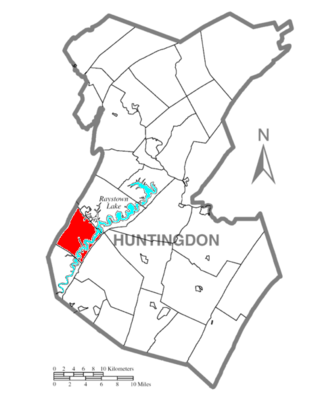
Lincoln Township is a township in Huntingdon County, Pennsylvania, United States. The population was 321 at the 2020 census.

<span class="mw-page-title-main">Pine Grove Township, Schuylkill County, Pennsylvania</span> Township in Pennsylvania, United States

Pine Grove Township is a township in Schuylkill County, Pennsylvania, United States. The population was 4,024 at the 2020 census.

<span class="mw-page-title-main">Walker Township, Schuylkill County, Pennsylvania</span> Township in Pennsylvania, United States

Walker Township is a township in Schuylkill County, Pennsylvania, United States. The population was 994 at the 2020 census.

<span class="mw-page-title-main">Fawn Township, York County, Pennsylvania</span> Township in Pennsylvania, United States

Fawn Township is a township in York County, Pennsylvania, United States. The population was 3,011 at the 2020 census.

<span class="mw-page-title-main">Bear Lake Township, Kalkaska County, Michigan</span> Civil township in Michigan, United States

Bear Lake Township is a civil township of Kalkaska County in the U.S. state of Michigan. As of the 2010 census, the township population was 667.

References

  1. 1 2 "U.S. Census website". United States Census Bureau . Retrieved 2008-01-31.
  2. "US Board on Geographic Names". United States Geological Survey. 2007-10-25. Retrieved 2008-01-31.