Rock Creek, Minnesota

Last updated

Rock Creek
The official logo of the City of Rock Creek, Minnesota.jpg
Pine County Minnesota Incorporated and Unincorporated areas Rock Creek Highlighted.svg
Location of the city of Rock Creek
within Pine County, Minnesota
Coordinates: 45°45′38″N92°54′32″W / 45.76056°N 92.90889°W / 45.76056; -92.90889
Country United States
State Minnesota
County Pine
IncorporatedNovember 4, 1970 [1]
Government
  MayorCraig Saari [2]
Area
[3]
  Total43.32 sq mi (112.20 km2)
  Land43.01 sq mi (111.40 km2)
  Water0.31 sq mi (0.80 km2)
Elevation
[4]
929 ft (283 m)
Population
 (2020)
  Total1,682
  Density39.10/sq mi (15.10/km2)
   Demonym
Rock Creekite
Time zone UTC-6 (Central (CST))
  Summer (DST) UTC-5 (CDT)
ZIP code
55067
Area code 320
FIPS code 27-54934 [5]
GNIS feature ID2396396 [4]
Website cityofrockcreekmn.com

Rock Creek is a city in Pine County, Minnesota, United States. The population was 1,628 at the 2010 census. [6] Portions of the Mille Lacs Indian Reservation are located within Rock Creek.

Contents

Interstate 35 and Minnesota State Highway 70 are two of the main routes in the community. Rock Creek is mostly a rural area, made up of farm lands.

Geography

According to the United States Census Bureau, the city has a total area of 43.32 square miles (112.20 km2), of which 43.01 square miles (111.40 km2) is land and 0.31 square miles (0.80 km2) is water. [7] It is by far the largest city by area in Pine County.

Demographics

Historical population
CensusPop.Note
1980 890
1990 1,04016.9%
2000 1,1197.6%
2010 1,62845.5%
2020 1,6823.3%
U.S. Decennial Census [8]

2010 census

As of the census [9] of 2010, there were 1,628 people, 582 households, and 441 families living in the city. The population density was 37.9 inhabitants per square mile (14.6/km2). There were 635 housing units at an average density of 14.8 per square mile (5.7/km2). The racial makeup of the city was 97.0% White, 0.4% African American, 0.7% Native American, 0.6% Asian, 0.1% from other races, and 1.2% from two or more races. Hispanic or Latino of any race were 1.1% of the population.

There were 582 households, of which 36.3% had children under the age of 18 living with them, 61.9% were married couples living together, 7.0% had a female householder with no husband present, 6.9% had a male householder with no wife present, and 24.2% were non-families. 17.2% of all households were made up of individuals, and 5.2% had someone living alone who was 65 years of age or older. The average household size was 2.76 and the average family size was 3.05.

The median age in the city was 39.1 years. 25.6% of residents were under the age of 18; 7.1% were between the ages of 18 and 24; 26.1% were from 25 to 44; 30.4% were from 45 to 64; and 10.7% were 65 years of age or older. The gender makeup of the city was 52.6% male and 47.4% female.

2000 census

As of the census [5] of 2000, there were 1,119 people, 389 households, and 301 families living in the city. The population density was 26.0 inhabitants per square mile (10.0/km2). There were 417 housing units at an average density of 9.7 per square mile (3.7/km2). The racial makeup of the city was 98.30% White, 0.09% African American, 0.80% Native American, 0.45% Asian, and 0.36% from two or more races. Hispanic or Latino of any race were 0.45% of the population.

There were 389 households, out of which 37.8% had children under the age of 18 living with them, 66.3% were married couples living together, 6.7% had a female householder with no husband present, and 22.4% were non-families. 15.7% of all households were made up of individuals, and 5.4% had someone living alone who was 65 years of age or older. The average household size was 2.88 and the average family size was 3.24.

In the city, the population was spread out, with 30.5% under the age of 18, 7.0% from 18 to 24, 28.4% from 25 to 44, 24.2% from 45 to 64, and 9.9% who were 65 years of age or older. The median age was 36 years. For every 100 females, there were 109.9 males. For every 100 females age 18 and over, there were 109.1 males.

The median income for a household in the city was $45,000, and the median income for a family was $48,482. Males had a median income of $33,523 versus $20,391 for females. The per capita income for the city was $17,281. About 6.8% of families and 11.5% of the population were below the poverty line, including 13.2% of those under age 18 and 12.9% of those age 65 or over.

Related Research Articles

<span class="mw-page-title-main">Rock Valley, Iowa</span> City in Iowa, United States

Rock Valley is a city in Sioux County, Iowa, the North Western corner of Iowa, United States, along the Rock River. The population was 4,059 at the time of the 2020 census.

<span class="mw-page-title-main">McGrath, Minnesota</span> City in Minnesota, United States

McGrath is a city in Aitkin County, Minnesota, United States. The population was 41 at the 2020 census.

Silver Township is a township in Carlton County, Minnesota, United States. The population was 389 as of the 2000 census. Silver Township took its name from Silver Creek.

<span class="mw-page-title-main">Watertown, Minnesota</span> City in Minnesota, United States

Watertown is a small city in Carver County, Minnesota, United States, along the South Fork of the Crow River, on the outskirts of the Twin Cities metro area. The population was 4,659 at the 2020 census.

Castle Rock Township is a township in Dakota County, Minnesota, United States. The population was 1,495 at the 2000 census.

<span class="mw-page-title-main">Rushford Village, Minnesota</span> City in Minnesota, United States

Rushford Village is a city in Fillmore County, Minnesota, United States. The population was 807 at the 2010 census. It surrounds the city of Rushford.

<span class="mw-page-title-main">Elmdale, Minnesota</span> City in Minnesota, United States

Elmdale is a city in Morrison County, Minnesota, United States. The population was 114 at the 2020 census.

<span class="mw-page-title-main">Hillman, Minnesota</span> City in Minnesota, United States

Hillman is a city in Morrison County, Minnesota, United States. The population was 23 at the 2020 census.

<span class="mw-page-title-main">Lastrup, Minnesota</span> City in Minnesota, United States

Lastrup is a city in Morrison County, Minnesota, United States. The population was 120 at the 2020 census.

<span class="mw-page-title-main">Brownsdale, Minnesota</span> City in Minnesota, United States

Brownsdale is a city in Mower County, Minnesota, United States. The population was 633 at the 2020 census.

<span class="mw-page-title-main">Rose Creek, Minnesota</span> City in Minnesota, United States

Rose Creek is a city in Mower County, Minnesota, United States. The population was 397 at the 2020 census.

<span class="mw-page-title-main">Deer Creek, Minnesota</span> City in Minnesota, United States

Deer Creek is a city in Otter Tail County, Minnesota, United States. The population was 330 at the 2020 census.

<span class="mw-page-title-main">Ottertail, Minnesota</span> City in Minnesota, United States

Ottertail is a city in Otter Tail County, Minnesota, United States. The population was 629 at the 2020 census.

<span class="mw-page-title-main">Denham, Minnesota</span> City in Minnesota, United States

Denham is a city in Pine County, Minnesota, United States. The population was 37 at the 2020 census.

<span class="mw-page-title-main">Ihlen, Minnesota</span> City in Minnesota, United States

Ihlen is a city in Pipestone County, Minnesota, United States. The population was 61 at the 2020 census.

<span class="mw-page-title-main">Beaver Creek, Minnesota</span> City in Minnesota, United States

Beaver Creek is a city in Rock County, Minnesota, United States. The town was platted in 1877 and named for the large number of beavers which were caught along the nearby creek throughout the late 1800s.

<span class="mw-page-title-main">Hills, Minnesota</span> City in Minnesota, United States

Hills is a city in Rock County, Minnesota, United States. Located approximately four miles (6 km) from the South Dakota border and two miles (3 km) from the Iowa border, it is the southwesternmost city in Minnesota. The population was 686 at the 2010 census.

<span class="mw-page-title-main">Dakota, Minnesota</span> City in Minnesota, United States

Dakota is a city in Winona County, Minnesota, United States. The population was 295 at the 2020 census.

<span class="mw-page-title-main">Rollingstone, Minnesota</span> City in Minnesota, United States

Rollingstone is a city in Winona County, Minnesota, United States. The population was 678 at the 2020 census.

<span class="mw-page-title-main">Minnesota Lake, Minnesota</span> City in Minnesota, United States

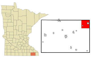
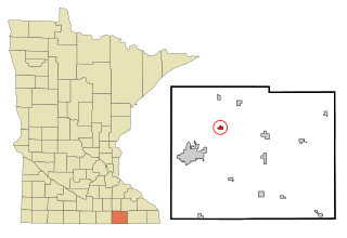
Minnesota Lake is a city in Blue Earth and Faribault counties in the State of Minnesota. The population was 661 at the 2020 census. The bulk of the city is in Faribault County; a small part extends into Blue Earth County.

References

  1. "Guide to Rock Creek Minnesota".
  2. "City Officials - Pine County Minnesota". Archived from the original on March 4, 2018. Retrieved July 28, 2017.
  3. "2020 U.S. Gazetteer Files". United States Census Bureau. Retrieved July 24, 2022.
  4. 1 2 U.S. Geological Survey Geographic Names Information System: Rock Creek, Minnesota
  5. 1 2 "U.S. Census website". United States Census Bureau . Retrieved January 31, 2008.
  6. "2010 Census Redistricting Data (Public Law 94-171) Summary File". American FactFinder. U.S. Census Bureau, 2010 Census. Retrieved April 23, 2011.[ dead link ]
  7. "US Gazetteer files 2010". United States Census Bureau. Archived from the original on January 25, 2012. Retrieved November 13, 2012.
  8. "Census of Population and Housing". Census.gov. Retrieved June 4, 2015.
  9. "U.S. Census website". United States Census Bureau . Retrieved November 13, 2012.