Rutledge, Minnesota

Last updated

Rutledge
Motto: 
"The Lonely Pine"
Pine County Minnesota Incorporated and Unincorporated areas Rutledge Highlighted.svg
Location of the city of Rutledge
within Pine County, Minnesota
Coordinates: 46°15′25″N92°52′11″W / 46.25694°N 92.86972°W / 46.25694; -92.86972
Country United States
State Minnesota
County Pine
IncorporatedFebruary 17, 1893 [1]
Government
  MayorRichard Holm [2]
Area
[3]
  Total3.02 sq mi (7.81 km2)
  Land2.95 sq mi (7.63 km2)
  Water0.07 sq mi (0.18 km2)
Elevation
[4]
1,030 ft (310 m)
Population
 (2020)
  Total212
  Density71.96/sq mi (27.78/km2)
   Demonym
Rutledgevian
Time zone UTC-6 (Central (CST))
  Summer (DST) UTC-5 (CDT)
ZIP code
55795
(North of Pine River)
55735
(South of Pine River)
Area code(s) 218 (North of Pine River)
320 (South of Pine River)
FIPS code 27-56518 [5]
GNIS feature ID2396462 [4]

Rutledge is a city in Pine County, Minnesota, United States, at the confluence of the Kettle and Pine Rivers. The population was 229 at the 2010 census. [6]

Contents

Pine County 61 serves as a main route in the community. The Willard Munger Bicycle / Snowmobile Trail also passes through Rutledge.

History

Long before it ever became an incorporated village, a group of Indigenous Americans lived along the banks of the Kettle River from where the community is today to a point about five miles downstream. The Government Road, a.k.a. Military Road, between St. Paul, Minnesota and Superior, Wisconsin passed through that area in the 1860s. A bridge was constructed across the Kettle River at what was called the Rock Dam. On the south side of the river, a station was built, at which stagecoaches stopped to change horses and allow passengers to get out and stretch their legs and have a lunch. It was at this location where the first Europeans settled. In 1870, the Lake Superior and Mississippi Railroad was completed in this region. A depot was built about two and one half miles upstream from the Rock Dam, named Kettle River Station. The community began to grow near the railroad station. On February 14, 1893, an election was held at the school house to decide whether the settlement should be incorporated as a village. A total of 22 votes were cast, 19 favoring incorporation. The Village of Rutledge was named after local lumberman Edward Rutledge, who had built several mills in the area. James D. McCormack served as the first Mayor of Rutledge.

Geography

According to the United States Census Bureau, the city has a total area of 3.03 square miles (7.85 km2), of which 2.96 square miles (7.67 km2) is land and 0.07 square miles (0.18 km2) is water. [7]

Demographics

Historical population
CensusPop.Note
1900 363
1910 89−75.5%
1920 901.1%
1930 955.6%
1940 16169.5%
1950 1631.2%
1960 146−10.4%
1970 123−15.8%
1980 18550.4%
1990 152−17.8%
2000 19628.9%
2010 22916.8%
2020 212−7.4%
U.S. Decennial Census [8]

2010 census

As of the census [9] of 2010, there were 229 people, 94 households, and 65 families living in the city. The population density was 77.4 inhabitants per square mile (29.9/km2). There were 130 housing units at an average density of 43.9 per square mile (16.9/km2). The racial makeup of the city was 96.9% White, 1.3% African American, 0.9% Native American, and 0.9% from two or more races. Hispanic or Latino of any race were 0.4% of the population.

There were 94 households, of which 30.9% had children under the age of 18 living with them, 54.3% were married couples living together, 9.6% had a female householder with no husband present, 5.3% had a male householder with no wife present, and 30.9% were non-families. 24.5% of all households were made up of individuals, and 7.4% had someone living alone who was 65 years of age or older. The average household size was 2.44 and the average family size was 2.89.

The median age in the city was 42.1 years. 21.8% of residents were under the age of 18; 6.2% were between the ages of 18 and 24; 28.4% were from 25 to 44; 31.5% were from 45 to 64; and 12.2% were 65 years of age or older. The gender makeup of the city was 51.1% male and 48.9% female.

2000 census

As of the census [5] of 2000, there were 196 people, 78 households, and 56 families living in the city. The population density was 66.5 inhabitants per square mile (25.7/km2). There were 110 housing units at an average density of 37.3 per square mile (14.4/km2). The racial makeup of the city was 96.94% White, 1.53% Native American, 1.53% from other races. Hispanic or Latino of any race were 1.53% of the population.

There were 78 households, out of which 30.8% had children under the age of 18 living with them, 60.3% were married couples living together, 9.0% had a female householder with no husband present, and 28.2% were non-families. 20.5% of all households were made up of individuals, and 10.3% had someone living alone who was 65 years of age or older. The average household size was 2.51 and the average family size was 2.95.

In the city, the population was spread out, with 24.5% under the age of 18, 6.6% from 18 to 24, 32.7% from 25 to 44, 26.0% from 45 to 64, and 10.2% who were 65 years of age or older. The median age was 35 years. For every 100 females, there were 100.0 males. For every 100 females age 18 and over, there were 100.0 males.

The median income for a household in the city was $33,750, and the median income for a family was $47,083. Males had a median income of $25,250 versus $21,667 for females. The per capita income for the city was $19,040. About 15.3% of families and 19.6% of the population were below the poverty line, including 37.5% of those under the age of eighteen and none of those 65 or over.

Related Research Articles

<span class="mw-page-title-main">Circle Pines, Minnesota</span> City in Minnesota, United States

Circle Pines is a city in Anoka County, Minnesota, United States. The population was 5,025 at the 2020 census.

<span class="mw-page-title-main">Kettle River, Minnesota</span> City in Minnesota, United States

Kettle River is a city in Carlton County, Minnesota, along the Kettle River, for which it was named. The population was 180 at the time of the 2010 census. It was incorporated in 1921.

Silver Township is a township in Carlton County, Minnesota, United States. The population was 389 as of the 2000 census. Silver Township took its name from Silver Creek.

<span class="mw-page-title-main">Pine River, Minnesota</span> City in Minnesota, United States

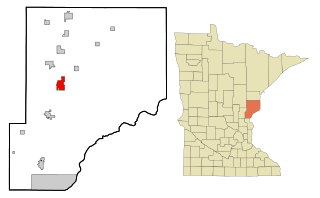
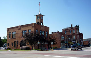
Pine River is a city in Cass County, Minnesota, United States. The population was 911 at the 2020 census. It is part of the Brainerd Micropolitan Statistical Area.

<span class="mw-page-title-main">Brook Park, Minnesota</span> City in Minnesota, United States

Brook Park is a city in Pine County, Minnesota, United States. The population was 139 at the 2010 census.

<span class="mw-page-title-main">Bruno, Minnesota</span> City in Minnesota, United States

Bruno is a city in Pine County, Minnesota, United States. The population was 102 at the 2010 census.

Chengwatana Township is a township in Pine County, Minnesota, United States. The population was 809 at the 2000 census. Chengwatana Township was organized in 1874. Its name is derived from the Ojibwe Zhingwaadena, applied originally to an Ojibwe village located at the confluence of the Snake River with the St. Croix River. Neighbouring Pine City Township and the City of Pine City get their names from the English translation of Chengwatana.

<span class="mw-page-title-main">Denham, Minnesota</span> City in Minnesota, United States

Denham is a city in Pine County, Minnesota, United States. The population was 37 at the 2020 census.

<span class="mw-page-title-main">Henriette, Minnesota</span> City in Minnesota, United States

Henriette, is a city in Pine County, Minnesota, United States. The population was 71 at the 2010 census.

<span class="mw-page-title-main">Hinckley, Minnesota</span> City in Minnesota, United States

Hinckley is a city in Pine County, Minnesota, United States, located at the junction of Interstate 35 and Minnesota State Highway 48. The population was 1,800 at the 2010 census.

<span class="mw-page-title-main">Kerrick, Minnesota</span> City in Minnesota, United States

Kerrick is a city in Pine County, Minnesota, United States. The population was 65 at the 2010 census.

Kettle River Township is a township in Pine County, Minnesota, United States. The population was 491 at the 2000 census.

Pine City Township is a township in Pine County, Minnesota, United States, located south and east of the city of Pine City. The township population was 1,249 at the 2000 census.

<span class="mw-page-title-main">Rock Creek, Minnesota</span> City in Minnesota, United States

Rock Creek is a city in Pine County, Minnesota, United States. The population was 1,628 at the 2010 census. Portions of the Mille Lacs Indian Reservation are located within Rock Creek.

<span class="mw-page-title-main">Sandstone, Minnesota</span> City in Minnesota, United States

Sandstone is a city in Pine County, Minnesota, United States, along the Kettle River. The population was 2,849 at the 2010 census.

Sandstone Township is a township in Pine County, Minnesota, United States. The population was 1,614 at the 2000 census.

<span class="mw-page-title-main">Sturgeon Lake, Minnesota</span> City in Minnesota, United States

Sturgeon Lake is a city in Pine County, Minnesota, United States. The population was 439 at the 2010 census.

<span class="mw-page-title-main">Willow River, Minnesota</span> City in Minnesota, United States

Willow River is a city in Pine County, Minnesota, United States, at the confluence of the Kettle and Willow Rivers. The population was 415 at the 2010 census.

<span class="mw-page-title-main">Pine Springs, Minnesota</span> City in Minnesota, United States

Pine Springs is a city in Washington County, Minnesota, United States. The population was 408 at the 2010 census.

<span class="mw-page-title-main">Pine Island, Minnesota</span> City in Minnesota, United States

Pine Island is a city in Goodhue and Olmsted counties in the U.S. state of Minnesota. Most of Pine Island is in Goodhue County, but a small part extends into Olmsted County, making that portion part of the Rochester metropolitan area. As of the 2020 census, the population was 3,769.

References

  1. "Guide to Rutledge Minnesota".
  2. "City Officials - Pine County Minnesota". Archived from the original on March 4, 2018. Retrieved July 28, 2017.
  3. "2020 U.S. Gazetteer Files". United States Census Bureau. Retrieved July 24, 2022.
  4. 1 2 U.S. Geological Survey Geographic Names Information System: Rutledge, Minnesota
  5. 1 2 "U.S. Census website". United States Census Bureau . Retrieved January 31, 2008.
  6. "2010 Census Redistricting Data (Public Law 94-171) Summary File". American FactFinder. U.S. Census Bureau, 2010 Census. Retrieved April 23, 2011.[ dead link ]
  7. "US Gazetteer files 2010". United States Census Bureau. Archived from the original on February 20, 2011. Retrieved November 13, 2012.
  8. "Census of Population and Housing". Census.gov. Retrieved June 4, 2015.
  9. "U.S. Census website". United States Census Bureau . Retrieved November 13, 2012.

History Section from a Bicentennial (1976) Article by Todd Liljedahl Used with Permission