Saint Peter's Square is a large plaza located directly in front of St. Peter's Basilica in Vatican City, the papal enclave in Rome, directly west of the neighborhood (rione) of Borgo. Both the square and the basilica are named after Saint Peter, an apostle of Jesus whom Catholics consider to be the first Pope.

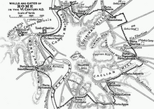
The Servian Wall is an ancient Roman defensive barrier constructed around the city of Rome in the early 4th century BC. The wall was built of volcanic tuff and was up to 10 m (33 ft) in height in places, 3.6 m (12 ft) wide at its base, 11 km (6.8 mi) long, and is believed to have had 16 main gates, of which only one or two have survived, and enclosed a total area of 246 hectares. In the 3rd century AD it was superseded by the construction of the larger Aurelian Walls as the city of Rome grew beyond the boundary of the Servian Wall.
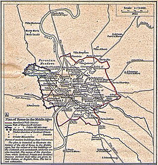
The Leonine City is the part of the city of Rome which, during the Middle Ages, was enclosed with the Leonine Wall, built by order of Pope Leo IV in the 9th century.

The Aurelian Walls are a line of city walls built between 271 AD and 275 AD in Rome, Italy, during the reign of the Roman Emperor Aurelian. They superseded the earlier Servian Wall built during the 4th century BC.

Borgo is the 14th rione of Rome, Italy. It is identified by the initials R. XIV and is included within Municipio I.

Campo Marzio is the 4th rione of Rome, Italy, identified by the initials R. IV. It belongs to the Municipio I and covers a smaller section of the area of the ancient Campus Martius. The logo of this rione is a silver crescent on a blue background.

The Porta San Paolo is one of the southern gates in the 3rd-century Aurelian Walls of Rome, Italy. The Via Ostiense Museum is housed within the gatehouse. It is in the Ostiense quarter; just to the west is the Roman Pyramid of Cestius, an Egyptian-style pyramid, and beyond that is the Protestant Cemetery.
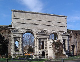
The Porta Maggiore, or Porta Prenestina, is one of the eastern gates in the ancient but well-preserved 3rd-century Aurelian Walls of Rome. Through the gate ran two ancient roads: the Via Praenestina and the Via Labicana. The Via Prenestina was the eastern road to the ancient town of Praeneste. The Via Labicana heads southeast from the city.

The Porta del Popolo, or Porta Flaminia, is a city gate of the Aurelian Walls of Rome that marks the border between Piazza del Popolo and Piazzale Flaminio.
Via Cornelia is an ancient Roman road that supposedly ran east–west along the northern wall of the Circus of Nero on land now covered by the southern wall of St. Peter's Basilica. The location is closely associated with the Via Aurelia and the Via Triumphalis.
Porta San Pancrazio is one of the southern gates of the Aurelian walls in Rome, Italy.

Porta Settimiana is one of the gates of the Aurelian walls in Rome, Italy. It rises at the northern vertex of the rough triangle traced by the town walls, built by Emperor Aurelian in the 3rd century, in the area of Trastevere an up through the Janiculum.

The Porta Nomentana was one of the gates in the Aurelian Walls of Rome, Italy. It is located along viale del Policlinico, around 70 m east of Porta Pia. It is now blocked and merely a boundary wall for the British Embassy.

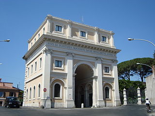
Porta Santo Spirito is one of the gates of the Leonine walls in Rome (Italy). It rises on the back side of the Hospital of the same name, in Via dei Penitenzieri, close to the crossing with Piazza della Rovere.

The Janiculum walls are a stretch of defensive walls erected in 1643 by Pope Urban VIII as a completion of the Leonine wall and for a better protection of the area of Rome rising on the right bank of the Tiber.

The Terebinth of Nero was a mausoleum built in ancient Rome that is important for historical, religious and architectural reasons. By the 14th century, it was almost completely demolished.

In ancient Rome, the Ager Vaticanus was the alluvial plain on the right (west) bank of the Tiber. It was also called Ripa Veientana or Ripa Etrusca, indicating the Etruscan dominion during the archaic period. It was located between the Janiculum, the Vatican Hill, and Monte Mario, down to the Aventine Hill and up to the confluence of the Cremera creek.

Borgo Vecchio, also named in the Middle Ages Via Sancta, Carriera Sancta or Carriera Martyrum, was a road in the city of Rome, Italy, important for historical and architectural reasons. The road was destroyed together with the adjacent quartier in 1936–37 due to the construction of Via della Conciliazione.
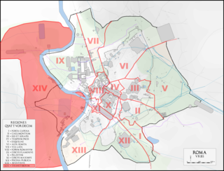
The Regio XIV Transtiberim is the fourteenth regio of imperial Rome, under Augustus's administrative reform. Meaning "across the Tiber", the Regio took its name from its position on the west bank of the Tiber River.