
Broadway is an unincorporated community in western Taylor Township, Union County, Ohio, United States. It has a post office with the ZIP code 43007. It lies along State Route 347 between Raymond and Magnetic Springs.

Raymond is a census-designated place in eastern Liberty Township, Union County, Ohio, United States. It has a post office with the ZIP code 43067. It is located at the intersection of State Routes 347 and 739. The population was 280 at the 2020 census.
Lilly Chapel is an unincorporated community in Fairfield Township, Madison County, Ohio, United States. It is located at the intersection of W. Jefferson Kiousville Road and Lilly Chapel Georgesville Road, approximately three miles west of Georgesville.

Byhalia is an unincorporated community in Washington Township, Union County, Ohio, United States. It is located the intersection of State Routes 31 and 739.
Essex is an unincorporated community on the east side of Rush Creek in the central part of Jackson Township, Union County, Ohio, United States. It is at the intersection of State Routes 37 and 739.
Somersville is an unincorporated community in York Township, Union County, Ohio, United States. It is located at the intersection of Ohio State Routes 31 and 47.

Peoria is an unincorporated community in Liberty Township, Union County, Ohio, United States. It is located along Raymond Road, about 1.75 miles south of Raymond and 6.5 miles northwest of Marysville.
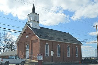
Pharisburg is an unincorporated community in Leesburg Township, Union County, Ohio, United States. It is located at the intersection of Ohio State Routes 4 and 347, about two miles west of Magnetic Springs.

New Dover is an unincorporated community in Dover Township, Union County, Ohio, United States. It is located along U.S. Route 36, about three miles east of Marysville.
Watkins is an unincorporated community in Mill Creek Township, Union County, Ohio, United States. It is located along Watkins Road, between U.S. Route 33 and U.S. Route 42, about five miles east of Marysville.

Arnold is an unincorporated community in Jerome Township, Union County, Ohio, United States. It is located along U.S. Route 42, between New California and Plain City.
Dipple is an unincorporated community in Paris Township, Union County, Ohio, United States. It is located about 2 miles (3.2 km) southeast of Marysville along U.S. Route 33 where Scottslawn Road intersects with the railroad tracks. The location of the original community is now wholly located on the Scotts Miracle-Gro Company property.

Cassella is an unincorporated community in Marion Township, Mercer County, Ohio, United States. Located at 40°24′22″N84°33′8″W, it lies at an elevation of 955 feet (291 m). Situated at the intersection of State Route 119 and Cassella-Montezuma Road in western Marion Township, it lies in the headwaters of Beaver Creek to the south of the city of Celina, the county seat of Mercer County. Other nearby communities include Maria Stein, 3 miles (4.8 km) to the east, Carthagena, 2 miles (3.2 km) to the north, and St. Henry, 4 miles (6.4 km) to the west.
Claysville is an unincorporated, rural community in Harrison County, Kentucky, United States; which was established by African Americans after the American Civil War ended in 1865. It is located on U.S. Route 62 at the Licking River.
Calumet is an unincorporated community in Knox Township, Jefferson County, Ohio, United States. It is located just north of Toronto between Ohio State Route 7 and the Ohio River. North 4th Street and North River Avenue both run continuously from Toronto to Calumet.
Reuben L. Partridge was an American pioneer and engineer in Union County, Ohio, known locally as "The Bridge Builder".
Otter is an unincorporated community in Paris Township, Union County, Ohio, United States. It is located at 40°16′33″N83°25′09″W, just northwest of Marysville, on the banks of Otter Run, at the intersection of Dog Leg Road and Westlake-Lee Road.
Petrea is an unincorporated community in Lick Township, Jackson County, Ohio, United States. It is located on Ohio State Route 788 between Jackson and Wellston, at the intersection of Fairgreens Road, at 39°04′24″N82°36′03″W.
Broadacre is an unincorporated community in Wayne Township, Jefferson County, Ohio, United States. It is located about 2.5 miles (4.0 km) northeast of Bloomingdale at the intersection of Ohio State Route 152 and Township Route 166.
Centerville is an unincorporated community in Prospect Township, Marion County, Ohio, United States. It is located about 10 miles (16 km) southwest of Marion at the intersection of Centerville-Green Camp Road and Centerville-Newmans Road, at 40°29′41″N83°14′36″W.

