
Chuckery is an unincorporated community located in far southwestern Darby Township, Union County, Ohio, United States. It is located at the intersection of State Routes 38 and 161.

Olivesburg is an unincorporated community in northeastern Weller Township, Richland County, Ohio, United States. It is part of the Mansfield Metropolitan Statistical Area. The town is on the bank of the Whetstone Creek, about two miles north of its junction with the Blackfork of the Mohican River. The community is served by the Ashland (44805) post office.

York Township is one of the fourteen townships of Union County, Ohio, United States. The 2020 census found 1,341 people in the township.

Broadway is an unincorporated community in western Taylor Township, Union County, Ohio, United States. It has a post office with the ZIP code 43007. It lies along State Route 347 between Raymond and Magnetic Springs.
Amity is an unincorporated community in north-eastern Canaan Township, Madison County, Ohio, United States. It is located at the intersection of Plain City-Georgesville Road and Amity Pike Road, between Plain City and West Jefferson.

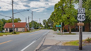
Lafayette is a census-designated place in the center of Deer Creek Township, Madison County, Ohio, United States. It is located along U.S. Route 40, just west of its intersection with U.S. Route 42. The population of Lafayette was 206 at the 2020 census.
Lilly Chapel is an unincorporated community in Fairfield Township, Madison County, Ohio, United States. It is located at the intersection of W. Jefferson Kiousville Road and Lilly Chapel Georgesville Road, approximately three miles west of Georgesville.
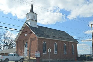
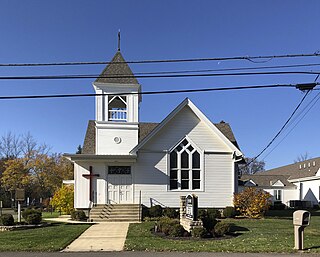
Summerford is an unincorporated community in Somerford Township, Madison County, Ohio, United States. It is located at the intersection of U.S. Route 40 and State Route 56.
Newport is an unincorporated community in Paint Township, Madison County, Ohio, United States. It is located along Ohio State Route 38 between London and Midway.
Tradersville is an unincorporated community in Somerford Township, Madison County, Ohio, United States.

Big Plain is an unincorporated community in Fairfield Township, Madison County, Ohio, United States. It is located at the intersection of West Jefferson-Kiousville Road and Big Plain-Circleville Road, approximately four miles north of Kiousville.

Byhalia is an unincorporated community in Washington Township, Union County, Ohio, United States. It is located the intersection of State Routes 31 and 739.
York Center is an unincorporated community in York Township, Union County, Ohio, United States. It is located at the intersection of State Routes 47 and 739.
Essex is an unincorporated community on the east side of Rush Creek in the central part of Jackson Township, Union County, Ohio, United States. It is at the intersection of State Routes 37 and 739.
Pottersburg is an unincorporated community in Allen Township, Union County, Ohio, United States. It is located along U.S. Route 33 between Marysville and Bellefountaine, about four miles west of Marysville.

New Dover is an unincorporated community in Dover Township, Union County, Ohio, United States. It is located along U.S. Route 36, about three miles east of Marysville.
Watkins is an unincorporated community in Mill Creek Township, Union County, Ohio, United States. It is located along Watkins Road, between U.S. Route 33 and U.S. Route 42, about five miles east of Marysville.
Jerome is an unincorporated community in Jerome Township, Union County, Ohio, United States. It is located at the intersection of Jerome Road and Scioto Road, about 2 miles east of New California.
Mabee Corner is an unincorporated community in Hamilton Township, Jackson County, Ohio, United States. It is located west of Oak Hill at the intersection of Bucklick Creek Road and Ohio State Route 139, at 38°54′10″N82°43′16″W.
Yellow Creek is an unincorporated community in Saline Township, Jefferson County, Ohio, United States. It is located northwest of Hammondsville at the intersection of Ohio State Route 7 and Ohio State Route 213 where the Yellow Creek empties into the Ohio River, at 40°34′28″N80°40′03″W.

