
| 1. Central 2. Coast 3. Eastern 4. Nairobi | 5. North Eastern 6. Nyanza 7. Rift Valley 8. Western |
 |
|---|
The provinces of Kenya were replaced by a system of counties in 2010.
| 1. Central 2. Coast 3. Eastern 4. Nairobi | 5. North Eastern 6. Nyanza 7. Rift Valley 8. Western |
| |
|---|
The provinces of Kenya were replaced by a system of counties in 2010.
Before the new constitution of Kenya that came into force on August 27, 2010, Kenya was divided into eight provinces (see map). The provinces, excluding Nairobi Province, were subdivided into 46 districts, which were further subdivided into 262 divisions. The divisions were subdivided into 2,427 locations and 6,612 sublocations. [1] A province was administered by a Provincial Commissioner. This division of these provinces was a result of the devolution that came into effect after the promulgation of the 2010 Constitution. [2]
Kenyan local authorities generally do not follow common boundaries with divisions. They are classified as city, municipality, town or county councils.
A third discrete type of classification are electoral constituencies. They are electoral areas without administrative functions, and are further subdivided into wards.
| Code | County | Province | Area (km2) | Population (2009 Census) | Location |
|---|---|---|---|---|---|
| 1 | Mombasa | Coast | 212.5 | 939,370 | Mombasa (City) |
| 2 | Kwale | Coast | 8,270.3 | 649,931 | Kwale |
| 3 | Kilifi | Coast | 12,245.9 | 1,109,735 | Kilifi |
| 4 | Tana River | Coast | 35,375.8 | 240,075 | Hola |
| 5 | Lamu | Coast | 6,497.7 | 101,539 | Lamu |
| 6 | Taita-Taveta | Coast | 17,083.9 | 284,657 | Voi |
| Sub-Totals | Coast | 79,686.1 | 3,325,307 | ||
| 7 | Garissa | North Eastern | 45,720.2 | 623,060 | Garissa |
| 8 | Wajir | North Eastern | 55,840.6 | 661,941 | Wajir |
| 9 | Mandera | North Eastern | 25,797.7 | 1,025,756 | Mandera |
| Sub-Totals | North Eastern | 127,358.5 | 2,310,757 | ||
| 10 | Marsabit | Eastern | 66,923.1 | 291,166 | Marsabit |
| 11 | Isiolo | Eastern | 25,336.1 | 143,294 | Isiolo |
| 12 | Meru | Eastern | 5,127.1 | 1,356,301 | Meru |
| 13 | Tharaka-Nithi | Eastern | 2,409.5 | 365,330 | Chuka |
| 14 | Embu | Eastern | 2,555.9 | 516,212 | Embu |
| 15 | Kitui | Eastern | 24,385.1 | 1,012,709 | Kitui |
| 16 | Machakos | Eastern | 5,952.9 | 1,098,584 | Machakos |
| 17 | Makueni | Eastern | 8,008.9 | 884,527 | Wote |
| Sub-Totals | Eastern | 140,698.6 | 5,668,123 | ||
| 18 | Nyandarua | Central | 3,107.7 | 596,268 | Ol Kalou |
| 19 | Nyeri | Central | 2,361.0 | 693,558 | Nyeri |
| 20 | Kirinyaga | Central | 1,205.4 | 528,054 | Kerugoya / Kutus |
| 21 | Murang'a | Central | 2,325.8 | 942,581 | Murang'a |
| 22 | Kiambu | Central | 2,449.2 | 1,623,282 | Kiambu |
| Sub-Totals | Central | 11,449.1 | 4,383,743 | ||
| 23 | Turkana | Rift Valley | 71,597.8 | 855,399 | Lodwar |
| 24 | West Pokot | Rift Valley | 8,418.2 | 512,690 | Kapenguria |
| 25 | Samburu | Rift Valley | 20,182.5 | 223,947 | Maralal |
| 26 | Trans Nzoia | Rift Valley | 2,469.9 | 818,757 | Kitale |
| 27 | Uasin Gishu | Rift Valley | 2,955.3 | 894,179 | Eldoret |
| 28 | Elgeyo-Marakwet | Rift Valley | 3,049.7 | 369,998 | Iten |
| 29 | Nandi | Rift Valley | 2,884.5 | 752,965 | Kapsabet |
| 30 | Baringo | Rift Valley | 11,075.3 | 555,561 | Kabarnet |
| 31 | Laikipia | Rift Valley | 8,696.1 | 399,227 | Rumuruti |
| 32 | Nakuru | Rift Valley | 7,509.5 | 1,603,325 | Nakuru(City) |
| 33 | Narok | Rift Valley | 17,921.2 | 850,920 | Narok |
| 34 | Kajiado | Rift Valley | 21,292.7 | 687,312 | Kajiado |
| 35 | Kericho | Rift Valley | 2,454.5 | 752,396 | Kericho |
| 36 | Bomet | Rift Valley | 1,997.9 | 730,129 | Bomet |
| Sub-Totals | Rift Valley | 182,505.1 | 10,006,805 | ||
| 37 | Kakamega | Western | 3,033.8 | 1,660,651 | Kakamega |
| 38 | Vihiga | Western | 531.3 | 554,622 | Vihiga |
| 39 | Bungoma | Western | 2,206.9 | 1,375,063 | Bungoma |
| 40 | Busia | Western | 1,628.4 | 743,946 | Busia |
| Sub-Totals | Western | 7,400.4 | 4,334,202 | ||
| 41 | Siaya | Nyanza | 2,496.1 | 842,304 | Siaya |
| 42 | Kisumu | Nyanza | 2,009.5 | 968,909 | Kisumu(City) |
| 43 | Homa Bay | Nyanza | 3,154.7 | 963,794 | Homa Bay |
| 44 | Migori | Nyanza | 2,586.4 | 917,170 | Migori |
| 45 | Kisii | Nyanza | 1,317.9 | 1,152,282 | Kisii |
| 46 | Nyamira | Nyanza | 912.5 | 598,252 | Nyamira |
| Sub-Totals | Nyanza | 12,477.1 | 5,442,711 | ||
| 47 | Nairobi | Nairobi | 694.9 | 3,138,369 | Nairobi (City) |
| Totals | 581,309.0 | 38,610,097 |
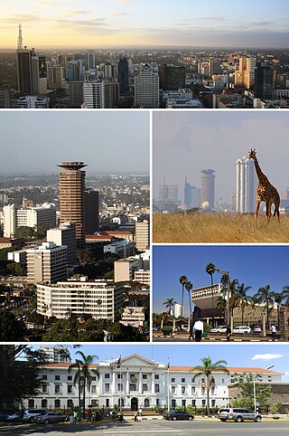
Nairobi is the capital and largest city of Kenya. The name is derived from the Maasai phrase Enkare Nairobi, which translates to 'place of cool waters', a reference to the Nairobi River which flows through the city. The city proper had a population of 4,397,073 in the 2019 census. The city is commonly referred to as The Green City in the Sun.
A county is a geographic region of a country used for administrative or other purposes in some nations. The term is derived from the Old French comté denoting a jurisdiction under the sovereignty of a count (earl) or a viscount. Literal equivalents in other languages, derived from the equivalent of "count", are now seldom used officially, including comté, contea, contado, comtat, condado, Grafschaft, graafschap, and zhupa in Slavic languages; terms equivalent to 'commune' or 'community' are now often instead used.

A district is a type of administrative division that in some countries is managed by the local government. Across the world, areas known as "districts" vary greatly in size, spanning regions or counties, several municipalities, subdivisions of municipalities, school district, or political district.
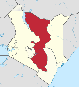
The Eastern Province of Kenya was one of 8 Provinces of Kenya. Its northern boundary ran along with that of Ethiopia; the North Eastern Province and Coast Province lay to the east and south; and the remainder of Kenya's provinces, including Central Province, ran along its western border. The provincial capital was Embu.
Embu is a town located approximately 125 kilometres (78 mi) northeast of Nairobi towards Mount Kenya. Embu served as the provincial capital of the former Eastern Province and currently serves as the headquarters of Embu County in Kenya. Located on the south-eastern foothills of Mount Kenya, the Municipality of Embu had a population of 204,979 in 2019 census. Embu is also the 8th Largest Municipality in Kenya. It is the commercial hub of the Central Eastern part of Kenya and provides an avenue for trade, tourism and highway transit between the national capital and the Northern Frontier.

Mombasa County is one of the 47 counties of Kenya. Its capital is Mombasa. In terms of economy it is second after Nairobi. Initially it was one of the former districts of Kenya but in 2013 it was reconstituted as a county, on the same boundaries. It is the smallest county in Kenya, covering an area of 229.7 km2 excluding 65 km2 of water mass. The county is situated in the south eastern part of the former Coast Province. It borders Kilifi County to the north, Kwale County to the south west and the Indian Ocean to the east. Administratively, the county is divided into seven divisions, eighteen locations and thirty sub-locations.
Kiambu is a town in Kiambu County, Kenya. It is 14 km (8.7 mi) from the capital Nairobi. It is the capital of Kiambu County, which bounds the northern border of Nairobi. Other proximate towns are Ruiru, Gatundu, Limuru and Kabete.
The Anglican Church of Kenya (ACK) is a province of the Anglican Communion, and it is composed by 41 dioceses. The current Leader and Archbishop of Kenya is Jackson Ole Sapit. The Anglican Church of Kenya claims 5 million total members. According to a study published in the Journal of Anglican Studies and by Cambridge University Press, the ACK claims 5 million adherents, with no official definition of membership, with nearly 2 million officially affiliated members, and 310,000 active baptised members. The church became part of the Province of East Africa in 1960, but Kenya and Tanzania were divided into separate provinces in 1970.

Kajiado County is a county in the former Rift Valley Province of Kenya. As of 2019, Kajiado county spanned an area of 21,292.7 km2, with a recorded population of 1,117,840. The county borders Nairobi and to its south it borders the Tanzanian regions of Arusha and Kilimanjaro. The county capital is Kajiado, but the largest town is Ongata Rongai. Its main tourist attraction is its wildlife.

Garissa County is an administrative county in Kenya. It is located in Eastern Kenya bordering Somalia to the East, Wajir County and Isiolo County to the North, Tana River County to the West and Lamu County to the South. Its capital and largest urban area is Garissa.
The subdivisions of Kenya have been in place since 2010, replacing the old system. Under the Constitution of 2010 and other reforms to Provincial Administration the country acquired a new system of Counties. The previous Provinces were scrapped and the 46 Districts, in existence since 1992, were turned into Counties with elected governments.

The districts of Kenya were divided into 262 divisions (matarafa). Divisions of Kenya were further subdivided into locations. Today's counties of Kenya are based on the merging of some of the districts on this list and since the divisions are one level under the districts they are now the sub-counties. This is because Kenya recently changed its constitution and 47 Counties emerged. Here are the divisions listed below, by district :
Kamukunji Constituency is an electoral constituency in Kenya. It is one of seventeen constituencies of Nairobi County. It consists of central to eastern areas of Nairobi. Kamukunji constituency had common boundaries with Pumwani Division of Nairobi. The entire constituency is located within Nairobi City County area. The constituency has an area of 8.80 km2 (3.4 sq mi). The constituency forms part of what was known as Nairobi Central Constituency at the 1963 elections. Kamukunji Constituency was conceived prior to the 1969 elections. The current constituency boundaries were revised prior to the 2013 elections. It borders Starehe Constituency to the west, Makadara to the south, Embakasi West Constituency to the east, and Mathare Constituency to the north.
A province is an administrative division within a country or state. The term derives from the ancient Roman provincia, which was the major territorial and administrative unit of the Roman Empire's territorial possessions outside Italy. The term province has since been adopted by many countries. In some countries with no actual provinces, "the provinces" is a metaphorical term meaning "outside the capital city".
Since Kenya gained independence in 1963, the constitution has been altered many times. During the early years of Kenya's existence, the constitution was abused by the president and the ruling party to gain and consolidate power. This was achieved through the creation of a single-party state, the abolition of secret ballots, and increasing the power and prestige that comes with the presidential position.

Sri Lanka is divided into 9 provinces, which are further subdivided into 25 districts. Districts are further subdivided into Divisional Secretary's Divisions. Each DS Division is divided into Grama Niladhari Divisions.
Vietnam is divided into 63 provinces and cities, with 5 cities and 58 provinces. It is a unitary state, so there is no such thing as a state or self-governing provinces.

Nairobi City County is one of the 47 counties of Kenya. With an estimated population of 5,454,000 in 2024, it is the third smallest yet the most populous of the counties, also serving as the capital of Kenya. In 2013, the county entity was effected, replacing Nairobi City Council, the long-standing unit of administration since pre-independence. The city county consists of eleven gazetted sub-counties and eighty five electoral wards. On the national level, Nairobi also sends seventeen Members of Parliament across the constituencies and one County Woman Representative to the National Assembly; one senator to the Senate. The county government, which is allocated devolved functions as per the constitution, is headed by the county governor, who appoints his cabinet. The county's legislature is headed by the County Speaker, who presides over the County Assembly: single-member elected Members of the County Assembly (MCAs) represent their respective electoral wards. Additional MCAs are also nominated by political parties as a form of affirmative action.
The Kenyan Regional Leagues are the fourth tier in the Kenyan football league system. They have a promotion and relegation system with FKF Division One and the Kenyan County Champions League, and consists of 8 regional leagues.
Sub-counties, also known as Districts, are the decentralised units through which government of Kenya provides functions and services. At national level, sub-counties take a more administrative function like security, statistical purposes, provision of government services, etc. Even though the sub-counties are divisions of counties, powers to create new national sub-counties lies with the national government. As of 2023, there are 314 sub-counties, compared to 290 constituencies. A deputy county commissioner is appointed by the state to lead each sub-county. The sub-counties are further divided into divisions, locations and sub-locations.